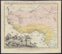
Guinea propria, nec non Nigritiæ vel Terræ Nigrovrm maxima pars, Guinee de meme que la plus grande partie du Pais des Negres, and Gvinee de meme que la plus grande partie du Pais des Negres
Description:
Covers West Africa from Gabon in the south to Niger, Mali, and Mauritania in the north., Has watermark., Includes indexed ill. depicting the dress, dwellings, and work of native Africans., Prime meridian: Ferro., and Relief shown pictorially.
Publisher:
Homannianorum Heredum,
Subject (Geographic):
Africa, West--Maps--Early works to 1800
Subject (Name):
Anville, Jean Baptiste Bourguignon d', 1697-1782 and Marchais, R. de
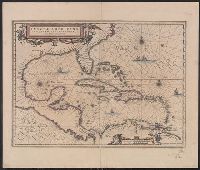
Insulae Americanae in Oceano Septentrionali cum terris adjacentibus and Insvlae Americanae in Oceano Septentrionali cum terris adiacentibus
Description:
Cf. Burden, P.D. Mapping of North America, 242., Cf. Koeman, C. Atlantes Neerlandici (1997 ed.), II, p. 600 (map 9600:2B)., Includes dedication to "D. Alberto Conradi Vander Burch" signed "tabulam hanc inscribit Guiljelmus Blaeu.", Includes embellished title cartouche, dedication with coats-of-arms, scale and ill. of ships at sea., and Includes scales in milliaria germanica and milliaria hispanica.
Publisher:
s.n.,
Subject (Geographic):
Caribbean Area--Maps--Early works to 1800, Mexico, Gulf of--Maps--Early works to 1800, and West Indies--Maps--Early works to 1800
Subject (Topic):
Coasts--North America--Maps--Early works to 1800 and Coasts--South America--Maps--Early works to 1800
Insulae Americanae in Oceano Septentrionali cum terris adjacentibus and Insvlae Americanae in Oceano Septentrionali cum terris adiacentibus
Description:
Appears in various French eds. of Jansson's Nouvel atlas., Includes embellished title cartouche, dedication with coat, Includes scales in milliaria germanica and milliaria hispanica., and Mounted on linen. Sheet measures 49.8 x 58.6 cm. Cross Collection no. 233.
Publisher:
Apud Ioannem Ianssonium,
Subject (Geographic):
Caribbean Area--Maps--Early works to 1800, Mexico, Gulf of--Maps--Early works to 1800, and West Indies--Maps--Early works to 1800
Subject (Name):
Jansson, Jan, 1588-1664. Atlas novus. French
Subject (Topic):
Coasts--North America--Maps--Early works to 1800 and Coasts--South America--Maps--Early works to 1800
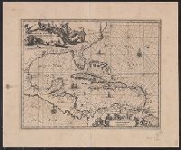
Insulae Americanae in Oceano Septentrionali cum terris adjacentibus
Description:
An unrecorded reduced version of Blaeu's map, where the cherub decorations on the cartouche and scale have been replaced by Native Americans, West Indians and Europeans. Coastlines vary sligh and Includes scales in milliaria germanica and milliaria hispanica.
Publisher:
s.n.,
Subject (Geographic):
Caribbean Area--Maps--Early works to 1800, Mexico, Gulf of--Maps--Early works to 1800, and West Indies--Maps--Early works to 1800
Subject (Topic):
Coasts--North America--Maps--Early works to 1800 and Coasts--South America--Maps--Early works to 1800
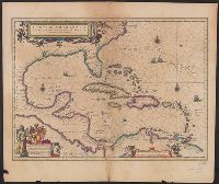
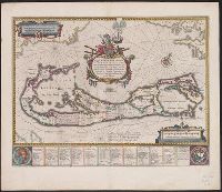
Insulae Americanae in Oceano Septentrionali cum terris adjacentibus and Insvlae Americanae in Oceano Septentrionali cum terris adiacentibus
Description:
From Willem Janszoon and Joan Blaeu's Theatrum orbis terrarum ... Amsterdami : Apud Guiljelmum et Iohannem Blaeu, 1635., Includes dedication to "D. Alberto Conradi Vander Burch" signed "tabulam hanc inscribit Guiljelmus Blaeu.", Includes embellished title cartouche, dedication with coats-of-arms, scale and ill. of ships at sea., and Includes scales in milliaria germanica and milliaria hispanica.
Publisher:
s.n.,
Subject (Geographic):
Caribbean Area--Maps--Early works to 1800, Mexico, Gulf of--Maps--Early works to 1800, and West Indies--Maps--Early works to 1800
Subject (Name):
Blaeu, Joan, 1596-1673. Theatrum orbis terrarum and Blaeu, Willem Janszoon, 1571-1638. Theatrum orbis terrarum
Subject (Topic):
Coasts--North America--Maps--Early works to 1800 and Coasts--South America--Maps--Early works to 1800
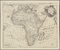
Africa accuraté in imperia, regna, status & populos divisa, ad usum serenissimi Bourgundiae Ducis.
Description:
"Avec privil[ège].", Appeared in various eds. of Cóvens et Mortier's Atlas noveau; cf. Koeman, C. Atlantes Neerlandici, Coverage includes the eastern coast of Brazil., II, C & M 3 and 4., Includes four bar scales., and Relief shown pictorially.
No. 13 of 69 maps bound together in composite atlas., Oriented with north towards upper left., Relief shown pictorially., Scale not given., and Title in Latin; place names in French.
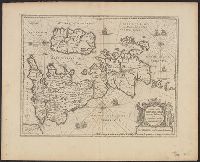
Mappa Aestivarvm insularum, alias Barmvdas dictarum
Description:
Based on Speed's map of 1626 but with new decorations., Below map, list of proprietors in 12 columns with arms of England and Bermuda., From the author's Theatre du monde ou nouvel atlas., Latin and English text on recto and French text on verso., Signature on verso: G., and Title on verso: L'Isle de Barmudas, avec ses voysines.
Publisher:
[Guillaume et Iean Blaeu,
Subject (Geographic):
Bermuda Islands--Maps--Early works to 1800
Subject (Name):
Blaeu, Joan, 1596-1673. Theatrum orbis terrarum. French and Blaeu, Willem Janszoon, 1571-1638. Theatrum orbis terrarum. French