Appeared in Willem and Joan Blaeu's Theatrum orbis terrarum., Backed with linen., Coordinates not present on map and are approximated., Relief shown pictorially., and With north oriented towards the upper right.
Subject (Geographic):
Netherlands--Maps--Early works to 1800
Subject (Name):
Blaeu, Joan, 1596-1673. Theatrum orbis terrarum, Blaeu, Willem Janszoon, 1571-1638. Theatrum orbis terrarum, and Ende, Josua van den, approximately 1584-approximately 1634, engraver
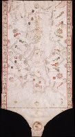
"Donnus Dominicus Vigliarolus Calaber de civitate Stili me fecit in urbe felicis Panormi 1577.", Color: red, green, and gold., Includes degrees of latitude along left edge: 60°N to 24°N., Includes six full compass roses, four half compass roses, and eight cherubs., Left portion of chart with illustration of the Pietá., and Title devised by cataloger.
Subject (Geographic):
Black Sea--Maps--Early works to 1800. and Mediterranean Sea--Maps--Early works to 1800.
Subject (Topic):
Nautical charts--Black Sea--Early works to 1800. and Nautical charts--Mediterranean Sea--Early works to 1800.
Jenkinson, Anthony, 1529-1611 Ortelius, Abraham, 1527-1598. Theatrum orbis terrarum Plantin, Christophe, approximately 1520-1589, printer
Call Number:
35 1562
Container / Volume:
BRBL_00099
Image Count:
1
Resource Type:
Maps, Atlases & Globes
Alternative Title:
Russiae, Moscoviae et Tartariae descriptio
Description:
"Cum priuilegio.", From Abraham Ortelius's Theatrum orbis terrarum (Antwerp, 1584)., Imperfect: slightly chipped along fold in center, with slight loss of text. Backed with paper., In Latin on verso., and Relief shown pictorially.
Anville, Jean Baptiste Bourguignon d', 1697-1782, cartographer
Call Number:
400 1764
Container / Volume:
BRBL_00233
Image Count:
1
Resource Type:
Maps, Atlases & Globes
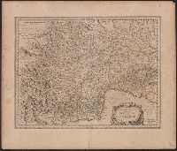
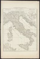
Description:
Appeared in Anville's Atlas général., Hand colored in outline., Includes 2 insets of Rome city region and "Urbs septicollis.", Includes four bar scales., Relief shown pictorially., and Watermark.
Subject (Geographic):
Italy--Historical geography--Maps--Early works to 1800 and Rome--Maps
Subject (Name):
Anville, Jean Baptiste Bourguignon d', 1697-1782. Atlas général
Appears in N. Vischer's Atlas minor sive geographia compendiosa, 1684., In lower right margin: Gedruckt t'Amsterdam by Frederick de Wit voor inde Calverstraet by den dam inde witte Pascaart., Map of Russian Far East, China and, and Sheet measures 45.5 x 56.5 cm.
Subject (Geographic):
China--Maps--Early works to 1800, Japan--Maps--Early works to 1800, and Russia (Federation)--Maps--Early works to 1800
Subject (Name):
L'Huilier, Joannes, engraver and Visscher, Nicolaes, 1649-1702. Atlas minor
Mounted on linen., Relief shown pictorially., and Variant without inset of "Fort Frederick oder Crown Point"; see B.B. McCorkle, Early printed maps of New England 1513-1800, 755.34.