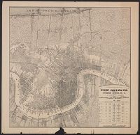
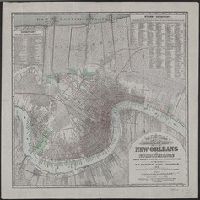
"Entered according to act of Congress in the year 1877 by T.S. Hardee in the office of the Librarian of Congress at Washington.", Also shows street railroads., Includes indexes and population figures., and Library's copy shows scale corrected in red ink from "feet" to "yds."
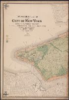
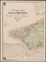
Includes color key., Includes three ancillary maps: "Section across Central Park, S, Publisher inferred by cataloger from statement of responsibility., Sheets numbered at upper right., and Supplementary statements of responsibility at lower left and right of map.
Publisher:
Julius Bien lith.],
Subject (Geographic):
Bronx (New York, N.Y.)--Maps, Manhattan (New York, N.Y.)--Maps, Randall's Island (New York, N.Y.)--Maps, Roosevelt Island (New York, N.Y.)--Maps, and Ward's Island (New York, N.Y.)--Maps
Subject (Name):
Bien, Julius, 1826-1909 and Quackenbush, Eugene
Subject (Topic):
Buildings--New York (State)--New York--Maps, Fills (Earthwork)--New York (State)--New York--Maps, Piers--New York (State)--New York--Maps, Ponds--New York (State)--New York--Maps, and Railroads--New York (State)--Ne
Copy 2: Ink ms. markings on verso., Ground characteristics map. Covers Manhattan and the Bronx, Roosevelt Island, Wa, Includes color key., Sheets numbered at upper right., and Supplementary statements of responsibility at lower left and right of map.
Publisher:
Julius Bien lith.],
Subject (Geographic):
Bronx (New York, N.Y.)--Maps, Manhattan (New York, N.Y.)--Maps, Randall's Island (New York, N.Y.)--Maps, Roosevelt Island (New York, N.Y.)--Maps, and Ward's Island (New York, N.Y.)--Maps
Subject (Name):
Bien, Julius, 1826-1909 and Quackenbush, Eugene
Subject (Topic):
Buildings--New York (State)--New York--Maps, Fills (Earthwork)--New York (State)--New York--Maps, Piers--New York (State)--New York--Maps, Ponds--New York (State)--New York--Maps, and Railroads--New York (State)--Ne
Geographical Surveys West of the 100th Meridian (U.S.)
Published / Created:
1881
Call Number:
844 T13 1877
Container / Volume:
BRBL_00611
Image Count:
1
Resource Type:
Maps, Atlases & Globes
Description:
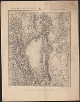
"Expeditions of 1876 & 1877 under the command of 1st Lieut. Geo. M. Wheeler, Corps of Engineers, U.S. Army.", "Reduced by heliogravure ... from original on scale of 1 inch to 1 mile.", Relief shown by hachures and spot heights., and Shows drainage, roads, railroads, etc.
Publisher:
Imp. Royal Geog. Institut,
Subject (Geographic):
Tahoe, Lake, Region (Calif. and Nev.)--Maps, Topographic