Composite atlas of 41 maps from Alexis Hubert Jaillot's Atlas nouveau.
Image Count:
1
Alternative Title:
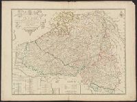
Provinces-Unies des Pays-Bas, sc̦avoir le Duché de Gueldre, les Comtés de Hollande, Zeelande, Zutphen
Description:
"Avec privilege du Roy.", Boundaries hand colored. Sheets measure 62.8 x 47.0 cm or smaller. No. 17 of 41 maps bound together with binder's title: Carte de Sanson., Cartouche signed "F. Chauveau in. et fe.", From Jaillot's Atlas nouveau (1681)., Includes 6 bar scales., Prime meridan: Ferro., Relief shown pictorially., and Watermark.
Publisher:
Chez H. Iaillot joignant les grands Augustins aux deux globes,
Subject (Geographic):
Netherlands--Maps--Early works to 1800 and North Rhine-Westphalia (Germany)--Maps--Early works to 1800
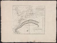
"Mer de Madagascar" to the north., "Plan Ideal" in manuscript above neat line in upper right corner., Possibly an idealized plan of a harbor and its defenses., Relief shown pictorially., Remnants of paper tabs on verso., and Watermarks.
Subject (Topic):
Fortification--Maps--Early works to 1800. and Harbors--Maps--Early works to 1800.
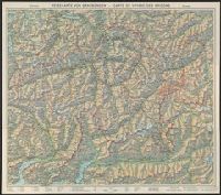
"Nr. 6210 BRB. 3.X.39"., Relief shown by shading, contours, and spot heights., and Text, illus., directory of mountain passes, and location map on verso.
Described as an untitled French translation of an unknown Mount and Page chart annotated by Benjamin Franklin in preparation for publication in London in De Vorsey's Imago mundi article. and Includes text, shows latitude and longitude figures in right and bot
Publisher:
Chéz Le Rouge, rue des Grands Augustine ...,
Subject (Geographic):
Gulf Stream--Maps--Early works to 1800
Subject (Name):
Franklin, Benjamin, 1706-1790
Subject (Topic):
Nautical charts--Atlantic Coast (North America)--Early works to 1800