Skip to search
Skip to main content
Skip to first result
Search
You Searched For
Format
cartographic
Subject (Topic)
World War, 1914-1918--Maps
New Search
Search Results
Published / Created:
[1916?]
Call Number:
11hc 1914R
Container / Volume:
BRBL_00010B
Image Count:
1
Resource Type:
Maps, Atlases & Globes
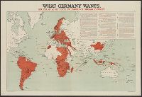
Description:
Date taken from text., In upper right corner: "14.", and Includes inset of quotations describing Germany's war aims.
Publisher:
Stanford's Geographical Establishment,
Subject (Geographic):
World maps
Subject (Topic):
World War, 1914-1918--Germany--War aims and World War, 1914-1918--Maps
Found in:
Beinecke Rare Book and Manuscript Library > What Germany wants : her claims as set forth by leaders of German thought.
Creator:
Published / Created:
[1918]
Call Number:
11hc 1917A
Container / Volume:
BRBL_00010D
Image Count:
1
Resource Type:
Maps, Atlases & Globes
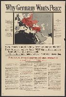
Description:
Includes "the Pan-German Plan as realized by War in Europe and in Asia, March 16, 1918"; shows colored map of Central Europe and its annexes in the Near East (Germany, Austria-Hungary, Bulgaria, Turkey); territory occupied or controlled by Central Powers;
Publisher:
Committee on Public Information,
Subject (Geographic):
Germany--Maps
Subject (Topic):
World War, 1914-1918--Maps
Found in:
Beinecke Rare Book and Manuscript Library > Why Germany wants peace : every American ought to know why we entered this War; every American ought to know why this conflict must continue until our aims are achieved; the publications listed below will give you this information.
Published / Created:
1940
Call Number:
11hc 1915C
Container / Volume:
BRBL_00010B
Image Count:
2
Resource Type:
Maps, Atlases & Globes
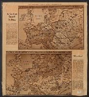
Description:
Includes ill. maps and text: "Printed about 1915 ... what would happen if the Allies won, a fearsome propaganda picture for the common German soldier ... were contained in an envelope which said The Map of Europe, how our enemies want to shape it and how
Publisher:
Herald Tribune,
Subject (Geographic):
Europe--Maps
Subject (Topic):
World War, 1914-1918--Maps
Found in:
Beinecke Rare Book and Manuscript Library > [A soldier saved a map.]
Published / Created:
191-.
Call Number:
11hcf 1919A-31
Container / Volume:
BRBL_00010N
Image Count:
2
Resource Type:
Maps, Atlases & Globes
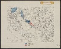
Description:
Shows territories "delimited by the Treaty of London" and "additional territory claimed in this memorandum."
Publisher:
s.n.,
Subject (Geographic):
Italy--Maps
Subject (Topic):
World War, 1914-1918--Maps
Found in:
Beinecke Rare Book and Manuscript Library > [Italian claims along the Adriatic Sea.]
Published / Created:
ca. 1914?]
Call Number:
30am 1914A
Container / Volume:
BRBL_00037
Image Count:
1
Resource Type:
Maps, Atlases & Globes
Description:
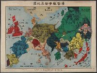
"No. 32". and In Russian, Japanese and English.
Subject (Geographic):
Europe--Maps
Subject (Topic):
World War, 1914-1918--Maps
Found in:
Beinecke Rare Book and Manuscript Library > [Pictorial war map, in Russian.]
Published / Created:
[1915?]
Call Number:
11hcf 1919A-32
Container / Volume:
BRBL_00010N
Image Count:
1
Resource Type:
Maps, Atlases & Globes
Alternative Title:
Pola, Zara, Comacchio
Description:
"B.4." in upper left margin., "Teilweise berichtigt bis I. V. 1915.", and Stamped "American Geographical Society" above left margin and "Loaned by the American Geographical Society, Broadway at 136th St., New York to The Peace Conference at Versailles 1918-1919
Publisher:
K.u.K. Militär geographisches Institut,
Subject (Geographic):
Croatia--Maps and Italy--Maps
Subject (Topic):
World War, 1914-1918--Maps
Found in:
Beinecke Rare Book and Manuscript Library > [Regional map of the area around the Adriatic Sea : showing the cities of Pola, Zara, Comacchio] / K.u.K. Militärgeographisches Institut.
Published / Created:
191-.
Call Number:
11hc 1915R
Container / Volume:
BRBL_00010C
Image Count:
2
Resource Type:
Maps, Atlases & Globes
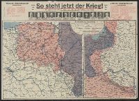
Description:
Includes 2 maps, text, and ill. and On verso: 4 anciallry maps, text, and ill.
Publisher:
Julius Hans Forkel,
Subject (Geographic):
Germany--Maps
Subject (Topic):
World War, 1914-1918--Maps
Found in:
Beinecke Rare Book and Manuscript Library > [So steht jetzt der Krieg!] : Kriegsoperationskarte über alle Kriegsschauplätze der welt.
Branch:v1.64.0 ,Deployed:2024-09-11T10:25:25-04:00