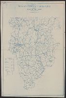
Blue line print., In lower left corner: R.W.D., Nov. 21, 1910. R 12-1-10. S, 4/1/12-S2 4/1/12., In lower right margin: Tolland Co. Conn, 905., and Indicates lettered routes, post offices, houses, schools, churches, and collection boxes.
Publisher:
s.n.],
Subject (Geographic):
Tolland County (Conn.)--Maps
Subject (Topic):
Postal service--Connecticut--Tolland County--Maps and Rural free delivery--Connecticut--Tolland County--Maps
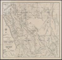
Includes inset of "Railroad connection between Reno and Rhodes." and Relief shown by hachures.
Publisher:
C.F. Weber & Co.],
Subject (Name):
C.F. Weber & Co
Subject (Topic):
Mines and mineral resources--California--Maps, Mines and mineral resources--Nevada--Maps, Mining districts--California--Maps, and Mining districts--Nevada--Maps
"Correction of names of allottees to date (Dec. 1, 1906) ....", "Made expressly for and sold exclusively by Ferd Reichmann, publisher of the Gregory County News, Bonesfeel S.Dak.", Copyright: E. Frank Peterson., In lower right: E.F.P. 12-1/8-06., Relief shown by hachures., and Shows township and range grid and names of land allottees.
Publisher:
E. Frank Peterson?],
Subject (Geographic):
Tripp County (S.D.)--Maps
Subject (Topic):
Indian allotments--South Dakota--Tripp County--Maps and Real property--South Dakota--Tripp County--Maps
In top margin: Atlas sheet no. 8., In top margin: Geology of the high plateaus of Utah by Capt. C.E. Dutton, U.S.A., Includes "note.", and Relief shown by hachures.
Publisher:
U.S. G.P.O.?,
Subject (Geographic):
Utah--Maps
Subject (Name):
Dutton, Clarence E. (Clarence Edward), 1841-1912. Topographical and geological atlas of the district of the high plateaus of Utah, Geographical and Geological Su, and Geographical and Geological Survey of the Rocky Mountain Region (U.S.)