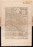
Plan of the country where the Prussian army gained a victory over the Austrians, Oct. 1, 1756. and Routes of the Prussian Armies into Bohemia
Description:
Bar scales given in "English miles 69 1/2 to a degree," "German miles 15 in a degree," and "Bohemian or gr ms. of Silesia 12 in a Deg.", Prime meridians: London and Ferro., Sheet measures 50.3 x 34.6 cm. No. 14 of 34 maps bound together., and With inset map: Plan of the country where the Prussian army gained a victory over the Austrians, Oct. 1, 1756.
Publisher:
T. Jeffreys,
Subject (Geographic):
Bohemia (Czech Republic)--Maps--Early works to 1800
Subject (Topic):
Seven Years' War, 1756-1763--Maps--Early works to 1800
"Emanl. Bowen sculp.", Insets: Plan of the Harbours of Ferrol and the Groyne -- Plan of St Sebastian -- Plan of Barcelona -- Plan of the Bay and City of Cadiz -- Plan of the Town and Fortifications of Gibralter -- Plan of the Town, Harbour & Fortifications of Port Mahone -- Plan of Dunkirk as given to the Duke of Ormond -- Plan of Dunkirk as demolished with the Projected Port of Mardyke., Relief shown pictorially., and Sheet measures 72.2 x 55.5 cm. No. 21 of 34 maps bound together.
Publisher:
T. Jefferys,
Subject (Topic):
Coasts--Europe, Western--Maps--Early works to 1800 and Nautical charts--Europe, Western--Early works to 1800
Bar scales given in "lieues d'une heure de chemin" and "miles d'Allemagne 16 au degré"., Imperfect: portions of cartouche cut-out, with some loss of text. Sheet measures 54.5 x 70.0 cm. No. 27 of 34 maps bound together., Inset: Plan de Breslaw, Capitale de la Silesie, scale [ca. 1:11,000], 15 x 21.4 cm., Prime meridian: Ferro., Relief shown pictorially., and Watermark.
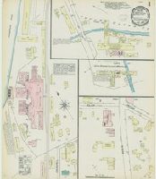
Sanborn fire insurance maps are a rich source of historic data on the urban built environment of North America during the 19th and early 20th centuries. The atlases were created for the purpose of underwriting fire insurance policies, which depended upon accurate and frequently-updated information about construction materials, municipal and transportation infrastructure, industrial and commercial landuse and more. The Yale University Library Map Department scanned its holdings of Sanborn fire insurance maps (consisting primarily of Connecticut towns) in order to make the maps more accessible.
Alternative Title:
May 1884, Thomaston, Conn.
Description:
"2 sheets.", Contains information on population, prevailing winds, water facilities and fire department., Partial cadastral map., and SMLMAPL 766 T36 1884: Sheets disbound. "Triplicate" stamp on both sheets. Library of Congress copyright stamp on title sheet.
Subject (Geographic):
Thomaston (Conn.)--Maps
Subject (Name):
Library of Congress Stamp
Subject (Topic):
Fire risk assessment--Connecticut--Thomaston--Maps and Real property--Connecticut--Thomaston--Maps
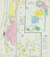
Sanborn fire insurance maps are a rich source of historic data on the urban built environment of North America during the 19th and early 20th centuries. The atlases were created for the purpose of underwriting fire insurance policies, which depended upon accurate and frequently-updated information about construction materials, municipal and transportation infrastructure, industrial and commercial landuse and more. The Yale University Library Map Department scanned its holdings of Sanborn fire insurance maps (consisting primarily of Connecticut towns) in order to make the maps more accessible.
Alternative Title:
Jan. 1890, Thomaston, Conn.
Description:
"3622. 3 sheets.", Contains information on population, prevailing winds, water facilities and fire department., Partial cadastral map., and SMLMAPL 766 T36 1890: Sheets disbound. "Triplicate" stamp on all sheets. Library of Congress copyright stamp on title sheet.
Subject (Geographic):
Thomaston (Conn.)--Maps
Subject (Name):
Library of Congress Stamp
Subject (Topic):
Fire risk assessment--Connecticut--Thomaston--Maps and Real property--Connecticut--Thomaston--Maps
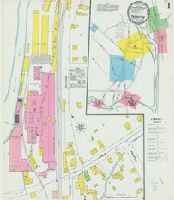
Sanborn fire insurance maps are a rich source of historic data on the urban built environment of North America during the 19th and early 20th centuries. The atlases were created for the purpose of underwriting fire insurance policies, which depended upon accurate and frequently-updated information about construction materials, municipal and transportation infrastructure, industrial and commercial landuse and more. The Yale University Library Map Department scanned its holdings of Sanborn fire insurance maps (consisting primarily of Connecticut towns) in order to make the maps more accessible.
Alternative Title:
Oct. 1895, Thomaston, Conn.
Description:
"6. 4 sheets.", Contains information on population, prevailing winds, water facilities and fire department., Includes index of specials., Partial cadastral map., and SMLMAPL 766 T36 1895: Sheets disbound. "Triplicate" stamp on all sheets. Library of Congress copyright stamp on title sheet.
Subject (Geographic):
Thomaston (Conn.)--Maps
Subject (Name):
Library of Congress Stamp
Subject (Topic):
Fire risk assessment--Connecticut--Thomaston--Maps and Real property--Connecticut--Thomaston--Maps
Sanborn fire insurance maps are a rich source of historic data on the urban built environment of North America during the 19th and early 20th centuries. The atlases were created for the purpose of underwriting fire insurance policies, which depended upon accurate and frequently-updated information about construction materials, municipal and transportation infrastructure, industrial and commercial landuse and more. The Yale University Library Map Department scanned its holdings of Sanborn fire insurance maps (consisting primarily of Connecticut towns) in order to make the maps more accessible.
Alternative Title:
Sep. 1900, Thomaston, Conn.
Description:
"4 sheets. 4187.", Contains information on population, prevailing winds, water facilities and fire department., Includes index of specials., Partial cadastral map., and SMLMAPL 766 T36 1900: Sheets disbound. "Triplicate" stamp on all sheets. Library of Congress copyright stamp on title sheet.
Subject (Geographic):
Thomaston (Conn.)--Maps
Subject (Name):
Library of Congress Stamp
Subject (Topic):
Fire risk assessment--Connecticut--Thomaston--Maps and Real property--Connecticut--Thomaston--Maps
Sanborn fire insurance maps are a rich source of historic data on the urban built environment of North America during the 19th and early 20th centuries. The atlases were created for the purpose of underwriting fire insurance policies, which depended upon accurate and frequently-updated information about construction materials, municipal and transportation infrastructure, industrial and commercial landuse and more. The Yale University Library Map Department scanned its holdings of Sanborn fire insurance maps (consisting primarily of Connecticut towns) in order to make the maps more accessible.
Alternative Title:
Dec. 1905, Thomaston, Conn.
Description:
"4 sheets. 8964.", Contains information on population, prevailing winds, water facilities and fire department., Includes index of streets and specials., Partial cadastral map., and SMLMAPL 766 T36 1905: Sheets disbound. "Triplicate" stamp on all sheets. Library of Congress copyright and Map Division stamps on title sheet.
Subject (Geographic):
Thomaston (Conn.)--Maps
Subject (Name):
Library of Congress Stamp and Library of Congress. Map Division Stamp
Subject (Topic):
Fire risk assessment--Connecticut--Thomaston--Maps and Real property--Connecticut--Thomaston--Maps
Sanborn fire insurance maps are a rich source of historic data on the urban built environment of North America during the 19th and early 20th centuries. The atlases were created for the purpose of underwriting fire insurance policies, which depended upon accurate and frequently-updated information about construction materials, municipal and transportation infrastructure, industrial and commercial landuse and more. The Yale University Library Map Department scanned its holdings of Sanborn fire insurance maps (consisting primarily of Connecticut towns) in order to make the maps more accessible.
Alternative Title:
Aug. 1911, Thomaston, Conn.
Description:
"3966. 5 sheets.", Contains information on population, prevailing winds, water facilities and fire department., Includes index of streets and specials., Partial cadastral map., and SMLMAPL 766 T36 1911: Sheets disbound. Library of Congress copyright stamp on title sheet.
Subject (Geographic):
Thomaston (Conn.)--Maps
Subject (Name):
Library of Congress Stamp
Subject (Topic):
Fire risk assessment--Connecticut--Thomaston--Maps and Real property--Connecticut--Thomaston--Maps