Search
You Searched For
Search Results
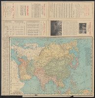
- Creator:
- Rand McNally and Company
- Published / Created:
- 1900
- Call Number:
- 50 1900
- Container / Volume:
- BRBL_00273
- Image Count:
- 2
- Resource Type:
- Maps, Atlases & Globes
- Description:
- Advertisements and text on margins and on verso. and Table of Treaty Ports on margin.
- Publisher:
- Rand, McNally & Co.,
- Subject (Geographic):
- Asia--Maps
- Found in:
- Beinecke Rare Book and Manuscript Library > Map of Asia : Printed for the New York Central's "Four-Track Series".
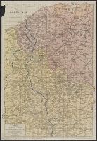
- Creator:
- Rand McNally and Company
- Published / Created:
- [c1917]
- Call Number:
- 11hc 1917B
- Container / Volume:
- BRBL_00010D
- Image Count:
- 2
- Resource Type:
- Maps, Atlases & Globes
- Description:
- In lower right corner: "For continuation of "French Front" South, see Section No. 2." and Index on verso.
- Publisher:
- Rand McNally and Co.,
- Subject (Geographic):
- Belgium--Maps and France--Maps
- Subject (Topic):
- World War, 1914-1918--Campaigns--Maps
- Found in:
- Beinecke Rare Book and Manuscript Library > Rand McNally war map of the British front : a strategic map of of the battleground in Belgium and northern France, from Ostend to St. Quentin / compiled from the latest military maps of the army staffs in Washington, London and Paris, and from other offic