Skip to search
Skip to main content
Skip to first result
Search
You Searched For
Genre
Maps
Creator
Rand McNally and Company
New Search
Search Results
Creator:
Published / Created:
[1912]
Call Number:
80gme 1912B
Container / Volume:
BRBL_00540
Image Count:
1
Resource Type:
Maps, Atlases & Globes
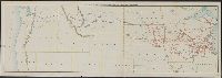
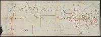
Description:
Covers the northwestern states, Illinois and Wisconsin. and Relief shown by hachures.
Publisher:
Rand McNally & Co.,
Subject (Geographic):
Northwestern States--Maps
Subject (Name):
Chicago, Milwaukee & Puget Sound Railway Company--Maps, Chicago, Milwaukee, and St. Paul Railway Company--Maps, and Tacoma Eastern Railroad--Maps
Subject (Topic):
Railroads--Northwestern States--Maps and Railroads--United States--Maps
Found in:
Beinecke Rare Book and Manuscript Library > Outline map of the lines of the Chicago, Milwaukee & St. Paul Railway Company, Chicago, Milwaukee & Puget Sound Railway Company, and Tacoma Eastern Railway Company : June 30, 1912.
Creator:
Published / Created:
1919]
Call Number:
30 1919
Container / Volume:
BRBL_00032
Image Count:
1
Resource Type:
Maps, Atlases & Globes
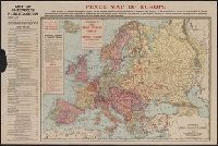
Alternative Title:
Rand McNally peace map of Europe
Publisher:
Rand McNally,
Subject (Geographic):
Europe--Maps
Found in:
Beinecke Rare Book and Manuscript Library > Peace map of Europe.
Creator:
Published / Created:
1907
Call Number:
28 1907
Container / Volume:
BRBL_00023E
Image Count:
1
Resource Type:
Maps, Atlases & Globes
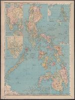
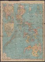
Description:
Insets: Manila -- Manila to Dagupan -- Philippine Islands and the China Sea -- Batanes (Bashee) and Babuyanes Is. -- Continuation of Sulu Archipelago.
Publisher:
Rand, McNally & Co.,
Subject (Geographic):
Philippines--Maps
Found in:
Beinecke Rare Book and Manuscript Library > Philippine Islands.
Creator:
Published / Created:
1901
Call Number:
28 1901
Container / Volume:
BRBL_00023E
Image Count:
2
Resource Type:
Maps, Atlases & Globes
Alternative Title:
Indexed pocket map of the Philippine Islands
Description:
Imperfect: Cover wanting., Includes four insets: Manila to Dagupan, Manila, Philippine Islands and the China Sea, and Batanes and Babuyanes Is., Index to provinces, islands, mountains, rivers and towns on verso., and Relief shown by hachures and spot heights.
Publisher:
Rand McNally],
Subject (Geographic):
Manila (Philippines)--Maps and Philippines--Maps
Found in:
Beinecke Rare Book and Manuscript Library > Philippine Islands.
Creator:
Published / Created:
[1942]
Call Number:
846 P837 1942
Container / Volume:
BRBL_00622
Image Count:
2
Resource Type:
Maps, Atlases & Globes
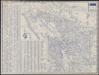
Alternative Title:
Downtown Portland. and Portland city map
Description:
"X.4002.", "X4004.", Indexed., Relief shown pictorially., and Text, photos, ill., and map of "Downtown Portland" on verso.
Publisher:
Rand McNally,
Subject (Geographic):
Portland (Or.)--Maps
Subject (Name):
Union Oil Company of California
Subject (Topic):
Central business districts--Oregon--Portland--Maps and Streets--Oregon--Portland--Maps
Found in:
Beinecke Rare Book and Manuscript Library > Portland street map / [prepared for] Union Oil Company.
Creator:
Published / Created:
c1904.
Call Number:
734 1904
Container / Volume:
BRBL_00379
Image Count:
1
Resource Type:
Maps, Atlases & Globes
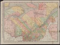
Alternative Title:
The Rand McNally new business atlas map of Quebec
Description:
Includes indexes to railroads and principal cities. and Inset: North eastern portion of Quebec -- Western portion of Quebec.
Publisher:
Rand McNally & Co.,
Subject (Geographic):
Québec (Province)--Maps
Subject (Topic):
Railroads--Québec (Province)--Maps and Roads--Québec (Province)--Maps
Found in:
Beinecke Rare Book and Manuscript Library > Quebec / Rand McNally and Company.
Creator:
Published / Created:
c1909.
Call Number:
734 1909
Container / Volume:
BRBL_00379
Image Count:
1
Resource Type:
Maps, Atlases & Globes
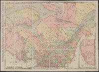
Alternative Title:
The Rand McNally new business atlas map of Quebec
Description:
Includes indexes to railroads and principal cities. and Inset: North eastern portion of Quebec -- Western portion of Quebec.
Publisher:
Rand McNally & Co.,
Subject (Geographic):
Québec (Province)--Maps
Subject (Topic):
Railroads--Québec (Province)--Maps and Roads--Québec (Province)--Maps
Found in:
Beinecke Rare Book and Manuscript Library > Quebec / Rand McNally and Company.
Branch:v1.61.6 ,Deployed:2024-06-12T09:55:36-04:00