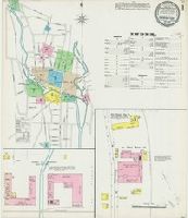
Sanborn fire insurance maps are a rich source of historic data on the urban built environment of North America during the 19th and early 20th centuries. The atlases were created for the purpose of underwriting fire insurance policies, which depended upon accurate and frequently-updated information about construction materials, municipal and transportation infrastructure, industrial and commercial landuse and more. The Yale University Library Map Department scanned its holdings of Sanborn fire insurance maps (consisting primarily of Connecticut towns) in order to make the maps more accessible.
Alternative Title:
Sep. 1896 Torrington, Conn.
Description:
"9 sheets 752.", Contains information on population, prevailing winds, water facilities and fire department., Includes index of streets and specials., Partial cadastral map., and SMLMAPL 766 T63 1896: Sheets disbound. "Triplicate" stamp on sheet. Library of Congress copyright stamp on title sheet.
Subject (Geographic):
Torrington (Conn.)--Maps
Subject (Name):
Library of Congress Stamp
Subject (Topic):
Fire risk assessment--Connecticut--Torrington--Maps and Real property--Connecticut--Torrington--Maps
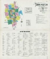
Sanborn fire insurance maps are a rich source of historic data on the urban built environment of North America during the 19th and early 20th centuries. The atlases were created for the purpose of underwriting fire insurance policies, which depended upon accurate and frequently-updated information about construction materials, municipal and transportation infrastructure, industrial and commercial landuse and more. The Yale University Library Map Department scanned its holdings of Sanborn fire insurance maps (consisting primarily of Connecticut towns) in order to make the maps more accessible.
Alternative Title:
Aug. 1924, Torrington, Conn.
Description:
"36 sheets. (1759).", Contains information on population, prevailing winds, water facilities and fire department., Includes index of streets and specials., Partial cadastral map., Sheets 2-16 and 18-22 at scale 1:600; sheets 17 and 23-36 at scale 1:1,200., and SMLMAPL 766 T63 1924: Sheets disbound. Library of Congress copyright stamp on title sheet.
Subject (Geographic):
Torrington (Conn.)--Maps
Subject (Name):
Library of Congress Stamp
Subject (Topic):
Fire risk assessment--Connecticut--Torrington--Maps and Real property--Connecticut--Torrington--Maps
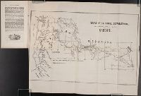
Sanborn fire insurance maps are a rich source of historic data on the urban built environment of North America during the 19th and early 20th centuries. The atlases were created for the purpose of underwriting fire insurance policies, which depended upon accurate and frequently-updated information about construction materials, municipal and transportation infrastructure, industrial and commercial landuse and more. The Yale University Library Map Department scanned its holdings of Sanborn fire insurance maps (consisting primarily of Connecticut towns) in order to make the maps more accessible.
Alternative Title:
Torrington, Conn. July 1931
Description:
"(1406)", "39 sheets.", Contains information on population, prevailing winds, water facilities and fire department., Includes index of streets and specials., Partial cadastral map., Sheets 2-16, 18-22, and 31-33 at scale 1:600; sheets 17, 23-30, and 34-39 at scale 1:1,200., and SMLMAPL 766 T63 1931: Sheets disbound. Library of Congress copyright stamp on title sheet.
Subject (Geographic):
Torrington (Conn.)--Maps
Subject (Name):
Library of Congress Stamp
Subject (Topic):
Fire risk assessment--Connecticut--Torrington--Maps and Real property--Connecticut--Torrington--Maps
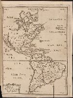
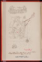
Kort beskrifning om provincien Nya Swerige uti America : som nu foertjden af the Engelske kallas
Image Count:
1
Description:
Preceding p. 1. and Teaching resource: Professor John Mack Faragher, History 141: The American West.
Subject (Geographic):
Canada --Discovery and exploration, South America --Discovery and exploration, United States --Discovery and exploration, and Western Hemisphere --Maps --Early works to 1800
Collection Created:
Stockholm : Tryckt uti Kongl. boktr. hos S. Wankijfs ankia, med egen bekostnad, af J. H. Werner, 1702
Society for the Propagation of the Faith T. Ireland
Published / Created:
1851 March
Call Number:
Zc13 M6 So3d
Collection Title:
Rapport sur les missions du diocese de Quebec [microform]
Image Count:
1
Subject (Geographic):
Canada --Church history, Missouri, Oregon --Maps, Walla Walla (Wash.) --Maps, Walla Walla Valley (Or. and Wash.), Washington (State), and Westport (Kansas City, Mo.)
Subject (Topic):
Catholic Church --Missions, Indians of North America --Missions --Canada, Missions --Northwest, Pacific, Missions --Oregon, and Missions --Quebec (Province)
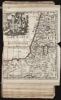
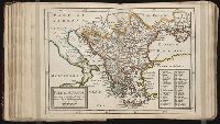
Twenty four new and accurate maps of the several parts of Europe ... : all (except the last) new
Image Count:
1
Alternative Title:
Turkey in Europe
Description:
In pencil on verso: 24. and Table of contents for maps 20-24 misnumbered.
Subject (Geographic):
Turkey --Maps
Subject (Name):
Barker, B. (Benjamin), d. 1764, bookseller, Clements, Henry, d. 1719, bookseller, King, Charles, d. 1735, bookseller, Nicholson, John, d. ca. 1717, bookseller, Parker, Richard, fl. 1692-1725, bookseller, and Tooke, Benjamin, d. 1716, bookseller
Subject (Topic):
Atlases --Early works to 1800
Collection Created:
[London] : Sold by J. Nicholson at the King’s-Arms in Little Britain, Benj. Barker and Charles King ..., Benj. Tooke ..., Hen. Clements ..., R. Parker and Ralph Smith under the Royal-Exchange ..., [1715?]