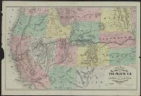
New trans-continental map of the Pacific R.R. and routes of overland travel to Colorado, Nebraska, the Black Hills, Utah, Idaho, Nevada, Montana, California and the Pacific coast
Description:
"Entered according to act of Congress in the year 1876 by H.T. Williams ...", Advertisements and text on verso., In lower margin: Am. Photo-Lithographic Co. N.Y. (Osborne's Process)., Relief shown by, and Shows completed and projected railroads and stage routes.
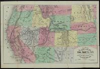
New trans-continental map of the Pacific R.R. and routes of overland travel to Colorado, Nebraska, the Black Hills, Utah, Idaho, Nevada, Montana, California, and the Pacific coast
Description:
"Entered according to act of Congress in the year 1877 by H.T. Williams ...", Advertisements, time tables, fare schedules, and text on verso., and Relief shown by hachures.
Preliminary record. and Surrounding the hemispheres are various illustrations showing female costumes of the different parts of the world, various views & monuments, pictures of 4 of the races, and various statistical tables 6 in number.
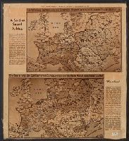
Includes ill. maps and text: "Printed about 1915 ... what would happen if the Allies won, a fearsome propaganda picture for the common German soldier ... were contained in an envelope which said The Map of Europe, how our enemies want to shape it and how
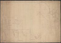
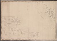
Engraved & Printed gy W.Hooker, New York. and Insets: Cape Fear River from its entrance to Smithville. Cape Fear, Cape Lookout. The Bar & Roads of Occracock.
Insets: Cape Fear River, from its entrance to Smithville. Scale [ca. 1:60,000] -- Beaufort harbour. Scale [ca. 1:40,000] -- The bar & roads of Occracock [sic]. Scale [ca. 1:100,000] -- Cape Hatteras. Scale [ca. 1:110,000] -- Cape Lookout. Scale [ca. 1:275
Publisher:
E. & G.W. Blunt,
Subject (Geographic):
Atlantic Coast (N.C.)--Maps., Beaufort (N.C.)--Maps., Cape Fear River Estuary (N.C.)--Maps., Fear, Cape (N.C.)--Maps., Hatteras, Cape (N.C.)--Maps., Lookout, Cape (N.C.)--Maps., and North Carol