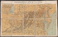
Map of the improved part of the province of Pennsylvania
Description:
2nd state of 2 known states. Distinguishing features of 2nd state: "Four [sic] long lines of text have been added at right of the Narrows of the Susquehannah at Nelson's Ferry. A road now leads east from Carlisle direct to Pine Ford" (Wheat and Brun 89).
Publisher:
sold by the author Nicholas Scull,
Subject (Geographic):
Pennsylvania--Administrative and political divisions--Maps--Early works to 1800 and Pennsylvania--Maps--Early works to 1800
Subject (Name):
Davis, John, fl. 1756-1759, Penn, Richard, 1706-1771. dedication, Penn, Thomas, 1702-1775. dedication, and Turner, James, d. 1759. engraver
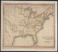
Also covers Washington, D.C., and parts of New Jersey, North Carolina, Kentucky and Pennsylvania., Includes list of "Altitudes of Mountains"., Inset map: Railroad ma, and Shows state and county boundaries, names of cities and towns, rivers, roads, and railroads.
Publisher:
Jacob Weiss lith.,
Subject (Geographic):
Delaware--Maps, Maryland--Maps, and Virginia--Maps