Manuscript documents and letters, illustrating the daily life and responsibilities of sea captains in the 18th and early 19th centuries. The collection includes documents relating to Captain Robert Poultney in Jamaica and letters on personal and naval matters addressed to Captain John Wainwright. Also included are descriptions of coastal areas and navigation hazzards, documents relating to obtaining supplies, a ship's newsletter, and a colored map ("Rochfort et les Environs").
Description:
Robert Poultney was the captain of the ship Loretta in Jamaica in 1762-1764., John Wainwright of the Royal Navy served in the East Indies and the Mediterranean, fought throughout the Napoleonic Wars, and is remembered for the destruction of the pirate town Ras-al-Kayma while captain of the ship Chiffonne., and In English, with one letter in French.
Subject (Geographic):
Mediterranean Region and Brittany (France)
Subject (Name):
Poultney, Robert., Wainwright, John, Captain., Chiffonne (Ship), Great Britain. Royal Navy, and Loretta (Ship)
Subject (Topic):
Officers, Sea life, Aids to navigation, Coasts, Navigation, Seafaring life, Ship captains, and Description and travel
France 1:4,000, Geographical Section, General Staff ; no. 4234, and GSGS (Series) ; 4234.
Description:
"1-44.", "AMS 1.", "Grid provisional, Lambert zone I grid.", "War Office 1943.", A few important streets and buildings are named; areas exposed at low tide are indicated., Major street names and buildings in French., and Relief show by rock drawings.
Publisher:
Army Map Service, U.S. Army, and War Office ;
Subject (Geographic):
Douarnenez (France)--Maps and Tréboul (France)--Maps
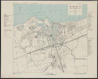
France 1:10,000, Geographical Section, General Staff ; no. 4234, and GSGS (Series) ; 4234.
Description:
"8-43.", "AMS 2.", "Grid provisional, Nord de Guerre zone grid.", "War Office 1943.", Important streets are named; list of important buildings, industries and port facilities in margin., and Major streets and buildings in French.
Bar scale given in Geometrical or Common Miles, British & French Leagues., Imperfect: 7 sheets wanting [upper right and upper middle sheets only]. Sheets measure 70.0 x 50.5 cm or smaller. No. 22 of 34 maps bound together., Includes explanation and scales; insets of "A map of Scotland" and "2d chart of the coast of France from Ostend to Ambleteuse.", and Relief shown pictorially.
France 1:5,000, Geographical Section, General Staff ; no. 4234, and GSGS (Series) ; 4234.
Description:
"1-44.", "First G.S.G.S. ed., 1943.", "Grid provisional. Nord de Guerre zone grid.", "War Office 1943.", Important street names, industries and port facilities are shown., Includes index., Major street names, some buildings, and sites in French., and Relief shown by
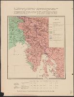
Map of Jugoslav territory and Map of Southern Slav territory
Description:
Imperfect: Cover wanting. Overprint in red on map indicating "Territory occupied by Italy 4000 S.q Mi.". Red stamp in upper right corner of sheet: "American Embassy. Paris, France Dec. 13, 1918"., Legend in English, Croatian, and French., and Sh
Publisher:
Christophers,
Subject (Geographic):
Yugoslavia--Maps and Yugoslavia--Maps--1915
Subject (Topic):
Ethnology--Yugoslavia--Maps and World War, 1914-1918--Maps
Italian revendications against Austria, which fought for Pangermanism against the Entente, and the Italian revendications against the Jugoslavs, who are the bulwark against the Pangermanism and therefore the natural allies of the Entente
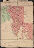
Description:
Date from French catalog record., Legend and text in French and English., and Ms. notes on map indicating Treaty of London Line, with corresponding ms. note "This is the correct interpretation of the position of Treaty of London Line. Italians w
Publisher:
Wuhrer,
Subject (Geographic):
Italy--Boundaries--Maps, Italy--Ethnology--Maps, Yugoslavia--Boundaries--Maps, and Yugoslavia--Ethnology--Maps
Subject (Topic):
World War, 1914-1918--Italy--Maps and World War, 1914-1918--Yugoslavia--Maps
Italian revendications against Austria, which fought for Pangermanism against the Entente, and the Italian revendications against the Jugoslavs, who are the bulwark against the Pangermanism and therefore the natural allies of the Entente
Description:
Date from French catalog record., Legend and text in French and English., Ms. notes on map indicating Treaty of London Line, with corresponding ms. note "This is the correct interpretation of the position of Treaty o, and Relief shown by shading.
Publisher:
Wuhrer,
Subject (Geographic):
Italy--Boundaries--Maps, Italy--Ethnology--Maps, Yugoslavia--Boundaries--Maps, and Yugoslavia--Ethnology--Maps
Subject (Topic):
World War, 1914-1918--Italy--Maps and World War, 1914-1918--Yugoslavia--Maps