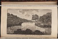
An historical, geographical, commercial, and philosophical view of the American United States, and
Image Count:
1
Description:
Facing p. 396.
Publisher:
Printed for the editor; J. Ridgway [etc.]
Subject (Geographic):
America --Description and travel, America --History --To 1810, Ohiopyle (Pa.), Pennsylvania --Pictorial works, and United States --Description and travel
Collection Created:
London, Printed for the editor; J. Ridgway [etc.] 1795
Copy 1 is lst issue in cloth; copies 2-5 are later issues in original wrappers with plain "A" on front cover; copies 2-4 are fourth issue, unnumbered; copy 5 is 5th issue, numbered. Cf. Byers, E.H. Robert Frost at Agnes Scott College; Wesleyan University.
Copy 1 is lst issue in cloth; copies 2-5 are later issues in original wrappers with plain "A" on front cover; copies 2-4 are fourth issue, unnumbered; copy 5 is 5th issue, numbered. Cf. Byers, E.H. Robert Frost at Agnes Scott College; Wesleyan University.
Copy 1 is lst issue in cloth; copies 2-5 are later issues in original wrappers with plain "A" on front cover; copies 2-4 are fourth issue, unnumbered; copy 5 is 5th issue, numbered. Cf. Byers, E.H. Robert Frost at Agnes Scott College; Wesleyan University.
BEIN 2003 Folio 85: Without book of directions mentioned after publisher statement. No. 10 of 45 maps bound together with binder's spine title: Atlas of America; ms. table of contents. Bookplate: Robinson. Bookplate of Paul Mellon., by James Cook, surveyor., Depths shown by soundings., Hand colored., Insets of enlarged harbors: Great Jervis Harbour, Harbours of St. Laurence, Harbour Briton [scale ca. 1:32,000]., Larken sc., and Scale [ca. 1:230,000].
Publisher:
Published ... by James Cook, and sold by I. Mount and T. Page ... Tho's. Jeffrey ... and And'w. Dury ... London
Subject (Topic):
Coasts -- Newfoundland and Labrador -- Maps -- Early works to 1800 and Nautical charts -- Newfoundland and Labrador -- Early works to 1800