The English pilot: describing the West-India navigation, from Hudson's-Bay to the river Amazones
Image Count:
2
Resource Type:
Maps, Atlases & Globes
Subject (Geographic):
Africa --Maps --Early works to 1800, Atlantic Ocean --Maps --Early works to 1800, Central America --Maps --Early works to 1800, Great Britain --Maps --Early works to 1800, Newfoundland and Labrador --Maps --Early works to 1800, North America --Maps --Early works to 1800, South America --Maps --Early works to 1800, Spain --Maps --Early works to 1800, and West Indies --Maps --Early works to 1800
Subject (Topic):
Navigation --Early works to 1800, Pilot guides --Atlantic Coast (U.S.) --Early works to 1800, and Pilot guides --Caribbean Area --Early works to 1800
Collection Created:
London : Printed for W. and J. Mount, T. Page and son, on Tower-Hill, MDCCLIX [1759]
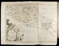
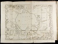
[Atlas factice of 96 maps by Blaeu, Visscher, Jansson, Hondius and others]
Image Count:
2
Description:
Imperfect: lower left corner [imprint] cut-out and replaced with ms. ill.; edges reinforced with ms waste. Sheet measures 38.5 x 48.9 cm. No. 67 of 92 maps bound together. and Numbered 72 on verso.
Broeck, Crispin van den, 1524-ca. 1591 Visscher, Nicolaes, 1618-1679
Published / Created:
[ca. 1660]
Call Number:
1983 Folio 19
Collection Title:
[Atlas factice of 96 maps by Blaeu, Visscher, Jansson, Hondius and others]
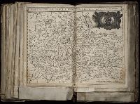
Image Count:
2
Alternative Title:
Armenia Maior and Asia et Armenia Minor
Description:
Imperfect: illustrations at top cut-out and replaced with ms. titles "Asia et Armenia minor" (upper left) and "Armenia minor" (in upper right); torn along fold and at left edge, with some loss of text. Sheet measures 32 x 47.8 cm. Reinforced along edges with printed waste. No. 85 of 92 maps bound together. and Numbered 91 on verso.
Publisher:
[Nicolaes Visscher]
Subject (Geographic):
Armenia --Maps --Early works to 1800, Assyria --Maps, Egypt --Maps --Early works to 1800, Middle east --Maps --Early works to 1800, Palestine --Geography --Maps --Early works to 1800, Saudi Arabia --Maps, Syria --Maps, and Turkey --Maps
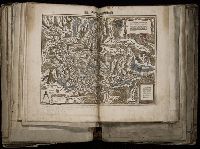
[Atlas factice of 96 maps by Blaeu, Visscher, Jansson, Hondius and others]
Image Count:
2
Description:
A set of 9 maps (no. IIII-XII) are from the Stumpf-Chronik., Hand col. Sheet measures 38.8 x 50 cm. Ms. notes in 19th century hand at bottom. Reinforced along edges with manuscript waste. No. 45 of 92 maps bound together., and Numbered 49 on verso.
Publisher:
[Christoffel Froschauer]
Subject (Geographic):
Germany, Southern --Maps --Early works to 1800 and Switzerland --Maps --Early works to 1800
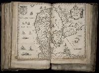
[Atlas factice of 96 maps by Blaeu, Visscher, Jansson, Hondius and others]
Image Count:
2
Description:
Imperfect: cartouche cut-out and replaced in ms. Sheet measures 38.1 x 49.3 cm. Reinforced along edges with printed waste. No. 84 of 92 maps bound together. and Numbered 90 on verso.
Publisher:
Apud Guiljelmum Blaeu
Subject (Geographic):
Salzburg (Austria : Land) --Maps --Early works to 1800