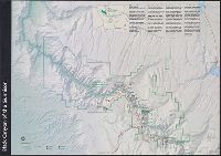
"*GPO: 2001--472-470/00404. Reprint 2001.", Includes text, area map, and map of the Cedar Pass area., Relief shown by shading., and Text and col. ill. on verso.
Eakins, Barry W Kaiyō Kagaku Gijutsu Sentā Monterey Bay Aquarium Research Institute University of Hawaii (System). School of Ocean and Earth Science and Technology
Published / Created:
2003
Call Number:
231 2003
Container / Volume:
BRBL_00020
Image Count:
1
Resource Type:
Maps, Atlases & Globes
Alternative Title:
Geologic investigations series / U.S. Department of the Interior, U.S. Geological Survey ; I-2809 and Geologic investigations series ; I-2809.
Description:
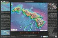
"Not to be used for navigation.", Ancillary maps: Bathymetry of the northwest Pacific Ocean -- 3-D perspective view of Hawaii -- Interpretive map of Hawaii's volcanoes., Bibliography., Includes text., and Relief and depths shown by satellite imagery.
Publisher:
U.S. Dept. of the Interior, U.S. Geological Survey,
Special publication (Nevada Bureau of Mines and Geology) ; 28. and Special publication ; 28
Description:
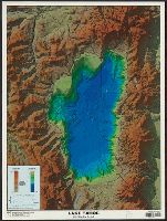
Includes elevation and depth graphs., Relief shown by shading, gradient tints, and spot heights. Depths shown by shading and gradient tints., and Shows roads, state boundary, Tahoe rim trail, and other geographic entities.
Publisher:
Nevada Bureau of Mines and Geology,
Subject (Geographic):
Tahoe, Lake (Calif. and Nev.)--Maps and Tahoe, Lake, Region (Calif. and Nev.)--Maps
Subject (Name):
Nevada Bureau of Mines and Geology and Pizarro, Kris Ann
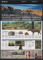
Includes text, col. ill., chronology in the form of a time-line, and population graph., Panel title., Relief shown by shading on landforms map., and Satellite image 1999 -- Landforms 1000 A.D. : [map] -- Aerial photograph 1998 : [col. photo] -- Bird's-eye view 1867 : [facsimile].
Publisher:
Map Link Inc. [distributor], and White Star Press ;
Subject (Geographic):
Minneapolis (Minn.)--Aerial views, Minneapolis (Minn.)--Aerial views--Facsimiles, Minneapolis (Minn.)--Remote-sensing images, Minneapolis Metropolitan Area (Minn.)--Remote-sensing images, and Minneapolis Region (Min
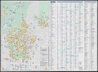
University of California Berkeley campus map, Berkeley street map, Albany, El Cerrito, Emeryville, Kensington, Oakland, Piedmont & Richmond, Lawrence Berkeley National Laboratory
Description:
"Published in cooperation with the University of California, Berkeley.", Both maps oriented with north towards the left., and Includes col. ill., "Berkeley through the years" timeline, vicinity map of San Francisco Bay area, campus building key, street index, and list of points of interest.
Publisher:
Rufus Graphics,
Subject (Geographic):
Berkeley (Calif.)--Maps
Subject (Name):
Rufus Graphics, University of California, Berkeley, and University of California, Berkeley--Maps