Skip to search
Skip to main content
Skip to first result
Search
You Searched For
Genre
Maps
Language
Latin
Publication Place
London :
New Search
Search Results
Creator:
Published / Created:
[1612?]
Call Number:
3191 1611
Container / Volume:
BRBL_00732
Image Count:
2
Resource Type:
Maps, Atlases & Globes
Description:
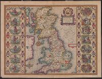
From Speed's The theatre of the empire of Great Britaine., Hand col. Sheet measures 42 x 55 cm. Lanman Collection., Left and right borders contain illustrations of notable persons from each of the 14 political districts., and Running title on verso: Heptarchiae
Publisher:
Are to be sold by John Sudbury & Georg. Humble,
Subject (Geographic):
Great Britain--Maps--Early works to 1800
Subject (Name):
Humble, George, d. 1640, Speed, John, 1552?-1629. Theatre of the Empire of Great Britaine, and Sudbury, John
Found in:
Beinecke Rare Book and Manuscript Library > Britain as it was devided in the tyme of the Englishe Saxons especially during their heptarchy / performed by Iohn Speede and are to be sold by John Sudbury & Georg. Humble, in Popes head alley at Londo[n].
Creator:
Published / Created:
1821
Call Number:
3190 No. 6
Container / Volume:
BRBL_00041
Image Count:
1
Resource Type:
Maps, Atlases & Globes
Description:
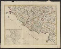
London meridian., Note: England Only., Relief shown pictorially., and Shows boundaries, roads and settlements.
Publisher:
Rich. Holmes Laurie,
Subject (Geographic):
England--Maps--Early works to 1800
Subject (Topic):
Romans--England--Maps--Early works to 1800
Found in:
Beinecke Rare Book and Manuscript Library > Britanniæ Antiquæ [cartographic material] : tabula geographica ex ævi Romani monumentis / ab eruditissimo viro Johanne Horsley ... recentissinmus observationibus concinnata.
Creator:
Published / Created:
1794
Call Number:
38 1794
Container / Volume:
BRBL_00153
Image Count:
1
Resource Type:
Maps, Atlases & Globes
Description:
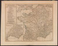
Below title: "MDCCLX, apud auctorem ... ", Inset maps: Provinciæ Romanæ ferè integræ tabula specialis et amplior. Scale [ca. 1:1,870,000] -- Batavorum Insulæ plenior descriptio., Prime meridian: Ferro., and Relief shown pictorially.
Publisher:
Published ... by Laurie & Whittle,
Subject (Geographic):
France--History--To 987--Maps--Early works to 1800 and Gaul--History--Maps--Early works to 1800
Subject (Name):
Robert Laurie and James Whittle, publishers
Found in:
Beinecke Rare Book and Manuscript Library > Gallia Antiqua ex Ævi Romani monumentis : eruta et serenissimi Carnutum Ducis munificientia publicijuris facta / auctor d'Anville.
Branch:v1.64.0 ,Deployed:2024-09-11T10:25:25-04:00