Search
You Searched For
Search Results
- Published / Created:
- 1919
- Call Number:
- 11hcf 1919C-7
- Container / Volume:
- BRBL_00010V
- Image Count:
- 6
- Resource Type:
- Maps, Atlases & Globes
- Found in:
- Beinecke Rare Book and Manuscript Library > Base Map of Somme Department: Taken from File No. 74-A-3 / American Commision to Negotiate Peace, War Damages in Allied Countries.
- Published / Created:
- 1919
- Call Number:
- 11hcf 1919C-11
- Image Count:
- 8
- Resource Type:
- Maps, Atlases & Globes
- Found in:
- Beinecke Rare Book and Manuscript Library > Base Map of Vosges Department: Taken from File No. 74-A-3 / American Commision to Negotiate Peace, War Damages in Allied Countries.
- Published / Created:
- 191-.
- Call Number:
- 11hcf 1919D-29
- Container / Volume:
- BRBL_00010X
- Image Count:
- 1
- Resource Type:
- Maps, Atlases & Globes
- Found in:
- Beinecke Rare Book and Manuscript Library > Belgique : Carte Administrative et Commerciale; chemins de fer, canaux, routes / publiée par "The Scarborough Co.", Éditeurs de Cartes Géographiques.
- Published / Created:
- 1859
- Call Number:
- 38 B64 1859
- Container / Volume:
- BRBL_00156
- Image Count:
- 1
- Resource Type:
- Maps, Atlases & Globes
- Found in:
- Beinecke Rare Book and Manuscript Library > Bordeaux.
- Published / Created:
- 1910
- Call Number:
- 38 B83 1910
- Container / Volume:
- BRBL_00156
- Image Count:
- 1
- Resource Type:
- Maps, Atlases & Globes
- Found in:
- Beinecke Rare Book and Manuscript Library > Bruyéres.
- Published / Created:
- [1850?]
- Call Number:
- 844 1850A
- Container / Volume:
- BRBL_00601
- Image Count:
- 1
- Resource Type:
- Maps, Atlases & Globes
- Found in:
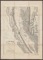
- Beinecke Rare Book and Manuscript Library > Californie aurifère : carte officielle, dressée d'aprés les ordres du Sénat, après l'annexion de cette province aux États-Unis / A. Girod, invt. ; Pellée, delt.
- Creator:
- Blondel la Rougery, Édouard, 1877-ca. 1918
- Published / Created:
- [between 1916 and 1918?]
- Call Number:
- 38 P21 1918
- Container / Volume:
- BRBL_00164A
- Image Count:
- 1
- Resource Type:
- Maps, Atlases & Globes
- Found in:
- Beinecke Rare Book and Manuscript Library > Carte Campbell [cartographic material] : Nouveau plan de Paris et banlieue : Indiquant toutes les voies nouvelles ainsi que les lignes du Métropolitain et Nord-Sud exploitées ou en construction / Ed. Blondel la Rougery.
- Published / Created:
- 1723
- Call Number:
- 50 1723
- Container / Volume:
- BRBL_00271
- Image Count:
- 1
- Resource Type:
- Maps, Atlases & Globes
- Found in:
- Beinecke Rare Book and Manuscript Library > Carte D'Asie ... Par Guillaume Delisle ...
- Published / Created:
- 1808
- Call Number:
- 39 1808
- Container / Volume:
- BRBL_00186
- Image Count:
- 4
- Resource Type:
- Maps, Atlases & Globes
- Found in:
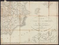
- Beinecke Rare Book and Manuscript Library > Carte D'Espagne et de Portugal ... Par E. Mentelle ... et P.G. Chanlaire ... 1808.
- Published / Created:
- 1777
- Call Number:
- 755 1777
- Container / Volume:
- BRBL_00431
- Image Count:
- 1
- Resource Type:
- Maps, Atlases & Globes
- Found in:
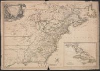
- Beinecke Rare Book and Manuscript Library > Carte Detaillee Des Possessions Angloises, dans l'Amerique Septentrionale ... E. Laysard, Sculp.