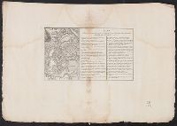
Mecometrie de leymant, cest a dire La maniere de mesvrer les longitudes par le moyen de l’eymant
Image Count:
1
Description:
Bound in preceding t.p. for pt. [2] (Premier livre de la Mecometrie arithmetique de l’eymant)., Imperfect: map rubbed, with some loss of map and text., Map has small tear on left edge at gutter., and Scale [ca. 1:100,000,000].
Subject (Topic):
Longitude --Early works to 1800 and World maps --Early works to 1800
Inscription on inside front cover: W. Hillhouse, London, 25th May 1852. Label for G.F. Cruchley on front cover and advertisement for Cruchley's extensive series of progressive school maps on inside front cover. and Title and imprint in top margin, date at bot
Subject (Geographic):
Paris (France)--Buildings, structures, etc.--Maps. and Paris (France)--Maps
Subject (Name):
Cruchley, G. F., Hillhouse, W.--Autograph, and Logerot, Auguste, 1804-1876
Subject (Topic):
Fortification--France--Paris--Maps., Streets--France--Paris--Indexes., and Streets--France--Paris--Maps.
Tardieu, P. F. (Pierre François), 1757-1822, author
Call Number:
45 1771
Container / Volume:
BRBL_00258
Image Count:
1
Resource Type:
Maps, Atlases & Globes
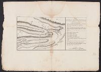
Description:
"A. Pl. 38.", Bar scales given in "Verstes" and "Lieue.", Coordinates not present on map and are approximated., From Nicolas-Gabriel Clerc's Histoire physique, morale, civile et politique de la Russie moderne., Includes index., and North oriented towards the botto
Subject (Geographic):
Tulcea (Romania : Județ)--Maps--Early works to 1800
Subject (Name):
Clerc, Nicolas-Gabriel, 1726-1798. Histoire physique, morale, civile et politique de la Russie moderne
The West-India pilot: containing piloting directions for Port Royal and Kingston harbours in
Image Count:
1
Subject (Geographic):
Atlantic Ocean --Maps --Early works to 1800, Santo Domingo (Dominican Republic) --Maps --Early works to 1800, and West Indies --Maps --Early works to 1800
Subject (Topic):
Harbors --Atlantic Coast (North America) --Maps --Early works to 1800, Nautical charts --Atlantic Coast (North America) --Early works to 1800, Nautical charts --Caribbean Area --Early works to 1800, Nautical charts --West Indies --Early works to 1800, Pilot guides --Atlantic Coast (North America) --Early works to 1800, Pilot guides --Caribbean Area --Early works to 1800, and Pilot guides --West Indies --Early works to 1800
Collection Created:
London : Printed for the author and sold by S. Hooper ..., MDCCLXXI [1771]
Tardieu, P. F. (Pierre François), 1757-1822, author
Call Number:
451 1785
Container / Volume:
BRBL_00258
Image Count:
1
Resource Type:
Maps, Atlases & Globes
Description:
"A. Pl. 36.", Bar scales given in "Echelle Russe" and "Echelle d'une Lieue Franc̦aise.", From Nicolas-Gabriel Clerc's Histoire physique, morale, civile et politique de la Russie moderne., Includes legend to right of map., North oriented towards the left., and Reli
Subject (Geographic):
Cahul (Moldova)--Maps--Early works to 1800
Subject (Name):
Clerc, Nicolas-Gabriel, 1726-1798. Histoire physique, morale, civile et politique de la Russie moderne
Tardieu, P. F. (Pierre François), 1757-1822, author
Call Number:
45 1785
Container / Volume:
BRBL_00258
Image Count:
1
Resource Type:
Maps, Atlases & Globes
Description:
"A. Pl. 37.", Bar scales given in "Verstes" and "Lieue.", Coordinates not present on map and are approximated., From Nicolas-Gabriel Clerc's Histoire physique, morale, civile et politique de la Russie moderne., and Imperfect: torn along fold at center, with no lo
Subject (Geographic):
Tulcea (Romania : Județ)--Maps--Early works to 1800
Subject (Name):
Clerc, Nicolas-Gabriel, 1726-1798. Histoire physique, morale, civile et politique de la Russie moderne
The West-India pilot: containing piloting directions for Port Royal and Kingston harbours in
Image Count:
1
Subject (Geographic):
Atlantic Ocean --Maps --Early works to 1800, Cap-Francais (Haiti), and West Indies --Maps --Early works to 1800
Subject (Topic):
Harbors --Atlantic Coast (North America) --Maps --Early works to 1800, Nautical charts --Atlantic Coast (North America) --Early works to 1800, Nautical charts --Caribbean Area --Early works to 1800, Nautical charts --West Indies --Early works to 1800, Pilot guides --Atlantic Coast (North America) --Early works to 1800, Pilot guides --Caribbean Area --Early works to 1800, and Pilot guides --West Indies --Early works to 1800
Collection Created:
London : Printed for the author and sold by S. Hooper ..., MDCCLXXI [1771]
The West-India pilot: containing piloting directions for Port Royal and Kingston harbours in
Image Count:
1
Subject (Geographic):
Atlantic Ocean --Maps --Early works to 1800, Haiti --Maps --Early works to 1800, and West Indies --Maps --Early works to 1800
Subject (Topic):
Harbors --Atlantic Coast (North America) --Maps --Early works to 1800, Nautical charts --Atlantic Coast (North America) --Early works to 1800, Nautical charts --Caribbean Area --Early works to 1800, Nautical charts --West Indies --Early works to 1800, Pilot guides --Atlantic Coast (North America) --Early works to 1800, Pilot guides --Caribbean Area --Early works to 1800, and Pilot guides --West Indies --Early works to 1800
Collection Created:
London : Printed for the author and sold by S. Hooper ..., MDCCLXXI [1771]