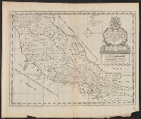
"Dedicated to His Highness William Duke of Glocester.", Appears in E. Wells' A new sett of maps both of antient and present geography., English, with Latin place names., Has watermark., Includes ornamental cartouche., and Relief shown pictorially.
Publisher:
s.n.,
Subject (Geographic):
Italy--Historical geography--Maps--Early works to 1800, Italy--History--To 476--Maps--Early works to 1800, and Rome--Maps--Early works to 1800
Subject (Name):
Nicholls, Sutton and Wells, Edward, 1667-1727. New sett of maps both of antient and present geography
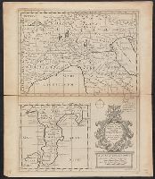
"Dedicated to His Highness William Duke of Glocester.", Appears in E. Wells' A new sett of maps both of antient and present geography., English, with Latin place names., Includes ornamental cartouche., Relief shown pictorially., and Watermarks: RDS, and fleur-de-l
Publisher:
s.n.,
Subject (Geographic):
Italy--Historical geography--Maps--Early works to 1800, Italy--History--To 476--Maps--Early works to 1800, and Rome--Maps--Early works to 1800
Subject (Name):
Nicholls, Sutton and Wells, Edward, 1667-1727. New sett of maps both of antient and present geography
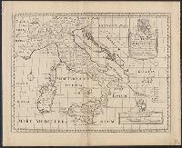
New sett of maps both of antient and present geography ...
Container / Volume:
BRBL_00041
Image Count:
1
Resource Type:
Maps, Atlases & Globes
Alternative Title:
New map of the British Isles, showing their ancient people, cities and towns of note in the time of the Romans
Description:
"Sutton Nicholls sculp.", Appears in Edward Wells's New sett of maps both of antient and present geography (1701)., Imprint derived from the atlas in which the map was issued., Kingdoms with boundaries, settlements with Latin names and rivers., and London meridia
Appears in various eds. of Atlas geographicus maior., Includes German text relating to English and French territorial claims., Neat lines measures 45.8 x 50.8 cm. on sheet 50 x 57.5 cm. Ms. note on verso: No. 151, Nord America nach d'Anville. Franklin Collection no. 131 1756-9., Place names and descriptive notes in English., Prime meridian: Ferro and London., and Relief shown pictorially.
Publisher:
[Homann Erben],
Subject (Geographic):
North America--Maps--Early works to 1800 and United States--History--French and Indian War, 1755-1763--Maps--Early works to 1800
Subject (Name):
Anville, Jean Baptiste Bourguignon d', 1697-1782 and Homann Erben (Firm). Atlas geographicus maior
Appears in various eds. of Atlas geographicus maior., Includes German text relating to English and French territorial claims., Place names and descriptive notes in English., Prime meridian: Ferro and London., Relief shown pictorially., and Sheet measures 47.5 x 51 cm.
Publisher:
[Homann Erben],
Subject (Geographic):
North America--Maps--Early works to 1800. and United States--History--French and Indian War, 1755-1763--Maps--Early works to 1800.
Subject (Name):
Anville, Jean Baptiste Bourguignon d', 1697-1782. and Homann Erben (Firm). Atlas geographicus maior.
755 1756E: Mounted on paper. Neat line measures 45.9 x 51 cm. on sheet 46 x 51.2 cm. Ms. no.: 54., Includes German text relating to English and French territorial claims., Prime meridian: Ferro and London., Relief sh, and Sheet measures 49.5 x 57.2 cm.
Publisher:
[Homann Erben],
Subject (Geographic):
North America--Maps--Early works to 1800 and United States--History--French and Indian War, 1755-1763--Maps--Early works to 1800
Subject (Name):
Anville, Jean Baptiste Bourguignon d', 1697-1782 and Homann Erben (Firm). Atlas geographicus maior
Appears in various eds. of Atlas geographicus maior., Includes German text relating to English and French territorial claims., Mounted on paper. Neat line measures 45.9 x 51 cm. on sheet 46 x 51.2 cm. Ms. no.: 54., and Place names and descriptive notes in Englis
Publisher:
[Homann Erben],
Subject (Geographic):
North America--Maps--Early works to 1800 and United States--History--French and Indian War, 1755-1763--Maps--Early works to 1800
Subject (Name):
Anville, Jean Baptiste Bourguignon d', 1697-1782 and Homann Erben (Firm). Atlas geographicus maior
Appears in various eds. of Atlas geographicus maior., Includes German text relating to English and French territorial claims., Place names and descriptive notes in English., Prime meridian: Ferro and London., Relief shown pictorially., and Sheet measures 47.1 x 52 cm. Ms. no. on verso: No. 5. Cross Collection no. 194.
Publisher:
[Homann Erben],
Subject (Geographic):
North America--Maps--Early works to 1800 and United States--History--French and Indian War, 1755-1763--Maps--Early works to 1800
Subject (Name):
Anville, Jean Baptiste Bourguignon d', 1697-1782 and Homann Erben (Firm). Atlas geographicus maior
Appears in various eds. of Atlas geographicus maior., Includes German text relating to English and French territorial claims., Place names and descriptive notes in English., Prime meridian: Ferro and London., Relief shown pictorially., and Sheet measures 49.5 x 61.7 cm. Title in ms. on verso. Franklin Collection no. 131 1777-1.
Publisher:
[s.n.],
Subject (Geographic):
North America--Maps--Early works to 1800 and United States--History--French and Indian War, 1755-1763--Maps--Early works to 1800
Subject (Name):
Anville, Jean Baptiste Bourguignon d', 1697-1782 and Homann Erben (Firm). Atlas geographicus maior