Skip to search
Skip to main content
Skip to first result
Search
You Searched For
Repository
Beinecke Rare Book and Manuscript Library
New Search
Search Results
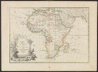
Creator:
Published / Created:
1789
Call Number:
60 1782
Container / Volume:
BRBL_00324
Image Count:
1
Resource Type:
Maps, Atlases & Globes
Description:
"Avec privilege du Roy.", Bookplate of Carl Van Vechten on verso., In upper right margin: no. 28., Prime meridian: Ferro., and Relief shown pictorially.
Publisher:
Chez Lattré graveur, ruë St. Jacques au près la fontaine St. Severin, à la Ville de Bordeaux,
Subject (Geographic):
Africa--Maps--Early works to 1800
Subject (Name):
Lattré, Jean and Van Vechten, Carl,--1880-1964--Bookplate
Found in:
Beinecke Rare Book and Manuscript Library > L'Afrique, divisée en ses principaux etats / par le Sr. Janvier, geographe.
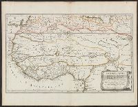
Creator:
Published / Created:
1655
Call Number:
655 1655
Container / Volume:
BRBL_00345
Image Count:
1
Resource Type:
Maps, Atlases & Globes
Description:
"Avec privilege du Roy, pour vingt ans.", "La coste des Negres, et Guinee, &c. est apres les observations de Samuel Blomart.", Has watermark., Relief shown pictorially., and Verso: numbered "24" in ink in upper right corner.
Publisher:
Chez Pierre Mariette, rue St. Iacques a l'Esperance,
Subject (Geographic):
Africa, North--Maps--Early works to 1800 and Africa, West--Maps--Early works to 1800
Subject (Name):
Blomart, Samuel and Somer Pruthenus, I
Found in:
Beinecke Rare Book and Manuscript Library > L'Afrique, ou Libie ulterieure : ou sont le Saara, ou desert, le pays des Negres, la Guinee, et les pays circonv. tirée en partie de Sanut, et de l'Arabe de Nubie, en partie de diverses cartes veües jusques a present / par le S. Sanson d'Abbeville, geog
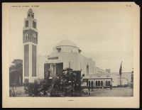
Creator:
Published / Created:
[1932?]
Call Number:
2006 +297
Collection Title:
L’exposition coloniale de Paris / introduction par Joseph Trillat
Image Count:
1
Description:
Plate 41
Publisher:
Calavas, A
Subject (Geographic):
Algeria--Buildings, structures, etc
Subject (Name):
Exposition coloniale internationale de Paris (1931)
Subject (Topic):
Colonial exhibitions., Decoration and ornament, Islamic, Exhibitions--France--Paris--Pictorial works, and Worlds fairs--France--Paris--1931
Collection Created:
Paris : Librairie des Arts Decoratifs, [1932?]
Found in:
Beinecke Rare Book and Manuscript Library > L'Algerie
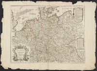
Published / Created:
1701
Call Number:
36 1701
Container / Volume:
BRBL_00117
Image Count:
1
Resource Type:
Maps, Atlases & Globes
Subject (Geographic):
Germany--Maps--Early works to 1800
Found in:
Beinecke Rare Book and Manuscript Library > L'Allemagne ... Par G. De L'Isle Geographe. Gravée par Jean Batiste Liébaux.
Published / Created:
[1720?]
Call Number:
36 1720
Container / Volume:
BRBL_00118
Image Count:
1
Resource Type:
Maps, Atlases & Globes
Publisher:
J. Covens et C. Mortier,
Subject (Geographic):
Germany--Maps--Early works to 1800
Found in:
Beinecke Rare Book and Manuscript Library > L'Allemagne ... Par G. De L'Isle Geographe. J. Condet, Sculpsit.
Published / Created:
1754
Call Number:
38345 1754
Container / Volume:
BRBL_00178
Image Count:
1
Resource Type:
Maps, Atlases & Globes
Subject (Geographic):
Bas-Rhin (France)--Maps--Early works to 1800
Found in:
Beinecke Rare Book and Manuscript Library > L'Alsace divisée en Haute et Basse et le Sundgau par le Sr. Robert.
Creator:
From the Collection: Pound, Ezra, 1885-1972
Published / Created:
1934
Call Number:
YCAL MSS 43
Container / Volume:
Box 1, folder 41
Image Count:
4
Found in:
Beinecke Rare Book and Manuscript Library > Ezra Pound Papers (YCAL MSS 43) > Series I: General Correspondence > L'Ambrosiano, Milan
Creator:
Published / Created:
[between 1780 and 1789?]
Call Number:
BrSides 2018 140
Image Count:
1
Resource Type:
Maps, Atlases & Globes
Alternative Title:
Atlante geografico.
Description:
Possibly issued in: Atlante geografico. Siena : Presso Pazzini Carli, 1788-1800., Prime meridian: Ferro., and Relief shown pictorially.
Publisher:
Presso Puzzini Carli,
Subject (Geographic):
Western Hemisphere--Maps--Early works to 1800.
Found in:
Beinecke Rare Book and Manuscript Library > L'America : divisa nelle sue principali parti.
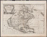
Creator:
Published / Created:
1687
Call Number:
71 1687
Container / Volume:
BRBL_00360
Image Count:
1
Resource Type:
Maps, Atlases & Globes
Description:
Relief shown pictorially., Stamped on verso: Yale, Horace Brown, 1900S., and Title in illustrative cartouche.
Publisher:
Gio. Giacomo de Rossi,
Subject (Geographic):
North America--Maps--Early works to 1800
Subject (Name):
Rossi, Giovanni Giacomo de, 17th cent and Widman, Georgio
Found in:
Beinecke Rare Book and Manuscript Library > L'America Settentrionale : nuovamente corretta, et accresciuta secondo le relationi più moderne / da Guglielmo Sansone ... e data in luce da Gio. Giacomo de Rossi ; Giorgio Widman Sculp.
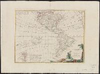
Creator:
Published / Created:
1776
Call Number:
70 1776B
Container / Volume:
BRBL_00724
Image Count:
1
Resource Type:
Maps, Atlases & Globes
Description:
Includes text and ill., Possibly from Zatta's Atlante novissimo [1788]., Relief shown by hachures., Sheet measures 42 x 57 cm. Verso: "14" in ink ms. Franklin Collection., and Shows also the Pacific Ocean to New Zealand.
Publisher:
Presso Antonio Zatta ... ,
Subject (Geographic):
America--Maps--Early works to 1800 and Pacific Ocean--Maps--Early works to 1800
Subject (Name):
Zuliani, Giuliano, ca. 1730-ca. 1814, engraver
Found in:
Beinecke Rare Book and Manuscript Library > L'America divisa ne' suoi principali stati : di nuova projezione / G. Zuliani, incise.
Branch:v1.61.6 ,Deployed:2024-06-12T09:55:36-04:00