The discoveries of John Lederer : in three several marches from Virginia, to the west of Carolina
Image Count:
1
Description:
Engraved by Cross. and Preceding title page.
Subject (Geographic):
North Carolina --Description and travel, North Carolina --Maps --Early works to 1800, Virginia --Description and travel, and Virginia --Maps --Early works to 1800
Subject (Name):
Talbot, William
Subject (Topic):
Indians of North America --North Carolina and Indians of North America --Virginia
The American military pocket atlas : being an approved collection of correct maps, both general and
Image Count:
1
Description:
Augst. 5th. 1776., Inset: A particular plan of Lake George. surveyed in 1756. By Capt. Jackson., and Teaching resource: Professor John Mack Faragher, History 141: The American West.
Publisher:
Printed for Robt. Sayer & Jno. Bennett, Map & Sea Chartsellers No. 53 Fleet Street, as the Act directs
Subject (Geographic):
North America --Maps --Early works to 1800 and United States --History --Revolution, 1775-1783 --Maps
Collection Created:
London : Printed for R. Sayer and J. Bennet, [1776]
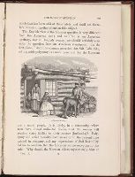
An historical, geographical, commercial, and philosophical view of the American United States, and
Image Count:
1
Description:
Facing p. 396.
Publisher:
Printed for the editor; J. Ridgway [etc.]
Subject (Geographic):
America --Description and travel, America --History --To 1810, Ohiopyle (Pa.), Pennsylvania --Pictorial works, and United States --Description and travel
Collection Created:
London, Printed for the editor; J. Ridgway [etc.] 1795
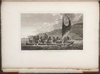
Bry, Theodor de, 1528-1598 Hariot, Thomas, 1560-1621
Published / Created:
1590
Call Number:
Taylor 194
Image Count:
71
Publisher:
Typis I. Wecheli, svmtibvs vero T. de Bry
Subject (Geographic):
North Carolina -- Description and travel -- Early works to 1800, Roanoke Colony (N.C.), Virginia --Description and travel, and Virginia --History --Colonial period, ca. 1600-1775 --Sources
Subject (Name):
Grenville, Richard, 1542-1591 and Raleigh's Roanoke colonies, 1584-1590
Subject (Topic):
Indians of North America --Pictorial works --Early works to 1800, Indians of North America --Virginia --Early works to 1800, and Indians of North America--North Carolina --Early works to 1800
Also appeared in Faden's [General atlas. London : William Faden, 1811?]., Includes relief profiles and inset map of "Positions ascertained by courses and distances given; on a scale reduced to the third.", No. 42 of 43 maps bound together in composite atlas., Relief shown pictorially; depths by soundings., and Scale [ca. 1:2,700,000].
Publisher:
Wm. Faden
Subject (Geographic):
Antilles, Lesser --Maps --Early works to 1800
Subject (Topic):
Nautical charts --Antilles, Lesser --Early works to 1800