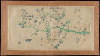
Bankoku ichiranzu, Bankoku ichiran zusetsu, and (Explanation of the visualized map of all the countries)
Description:
BEIN 2018 +512: Manuscript annotations in English on margins of map., Cover attached; cover and map title the same., Accompanied by: BANKOKU ICHIRAN ZUSETSU : (Explanation of the visualized map of all the countries) / Koyano Yoshiharu. -- Bunka 7 : (1810). -- 2 v., ill. ; 25.2 x 18 cm., Kôzanrō is a private school of Koyano Yoshiharu., and California shown as an island.
Publisher:
Kôzanrô, (June, 1809)
Subject (Geographic):
Japan and Japan.
Subject (Topic):
World maps, Geography, Study and teaching, and Prints, Japanese
Twentieth century forgery of a portlan chart with seaport names given for all coastlines; based on chart from the circle of Vesconte Maggiolo., Title devised by cataloger., Pen-and-ink in gold, brown, red, blue, and green., Contains eight compass roses., Decoration: armorial shields, city views with gilded banners, tents, and Madonna with child., Pasted on wood backing with modern brocade edging., and Coordinates not present on map and are approximated.
Subject (Geographic):
Mediterranean Sea, North Atlantic Ocean, Black Sea, Africa, West, Mediterranean Sea., North Atlantic Ocean., Black Sea., and Africa, West.
Title devised by cataloger., "Vinc[enti]us demetrei Volcius Rachuseus. Fecit interra Liiburni die 24 Maius 1601.", With blue cloth tie at left edge., Color: red, blue, and some gold., With four compass roses., and Coordinates not present on map and are approximated.