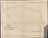
BEIN BrSides Folio 2014 10: Imperfect: torn and mutilated, with lower right corner missing., "Area 18 acres.", and Removed from: History of the city burial ground, in New Haven, together with the names of the owners of the lots therein (1863).
Publisher:
publisher not identified and Lith. by Punderson & Crisand
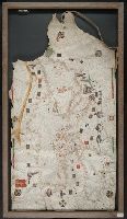
BEIN Art Storage 49cea 1425: Imperfect: lower left corner and bottom edge torn, with some loss of map; slight holes throughout. With leather thone tie on left edge., Portolan chart with seaport names given for all coastlines., Title devised by cataloger., Pen-and-ink in black, red, blue and green., Constantinople shown still in Christian possession; Thrace in possession of the Turks., Contains two compass roses., and Decoration: city views with banners.
Title supplied by cataloger., Nineteenth century forgery of a portlan chart., Manuscript note in accompanying case: A manuscript portolan on vellum probably executed by a Spanish chartmaker circa 1550, the coasts outlined in green with place names in gothic letters of red and black, decorated with devices of the sun and moon in umber heightened with gold, 14 x 9 inches. This chart is a rare example from its unusally small size. RH. 7487., and Pen and ink wash color on parchment, in Italian, in unidentified hand.
BEIN BrSides Zc35 908un: Holes punched in margins.
Publisher:
Dept. of the Interior, General Land Office, Andrew B. Graham Co.)
Subject (Geographic):
Cheyenne River Indian Reservation (S.D.), Standing Rock Indian Reservation (N.D. and S.D.), South Dakota, Cheyenne River Indian Reservation., United States, and Standing Rock Indian Reservation.
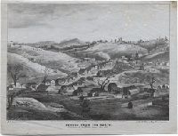
Goddard, George H. (George Henry), 1817-1906, artist
Published / Created:
May 1853.
Call Number:
WA Prints 391
Image Count:
1
Resource Type:
cartographic image
Description:
BEIN copy 1: Foxed with fading. On sheet 21 x 26 cm., BEIN copy 2: Foxed. On sheet 21 x 26 cm., Coordinates not present on map and are approximated., and Relief shown pictorially.
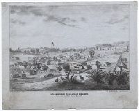
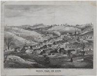
Goddard, George H. (George Henry), 1817-1906, artist
Published / Created:
May 1853.
Call Number:
WA Prints 432
Image Count:
1
Resource Type:
cartographic image
Description:
BEIN WA Prints 432 copy 1: On sheet: 23 x 28 cm., BEIN WA Prints 432 copy 2: Imperfect: Foxed, with some fading. On sheet: 21 x 27 cm., Relief shown pictorially., and Coordinates not present on map and are approximated.
Peutinger table and Tabvla itineraria ex illvstri Pevtingerorvm Bibliotheca
Description:
BEIN 2016 +333: Imperfect: title panel mutilated, with some loss of text. Sheets joined together to form a roll; backed in linen., Relief shown pictorially., "MD" in publication date in apostrophic forms., Appears in Ortelius' Theatri Orbis Terrarum Parergon. Antwerp, 1624., and "Peutinger Table: Road map of Western Roman Empire about 250 A.D. bought by Conrad Peutinger and published in Venice by Aldus in 1591 (2 sections only), in Antwerp 1598 (12 sections) ... The only record of Roman map making that has survived to the present day."--Tooley's Dictionary of Mapmakers. New York, 1979.