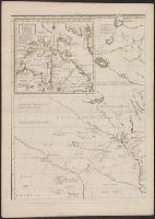
Anville, Jean Baptiste Bourguignon d', 1697-1782 Gravelot, Sr Major, Sr
Published / Created:
1746
Call Number:
2003 Folio 85
Image Count:
1
Description:
Inset map: [Hudson Bay-Labrador Region]. and No. 2 of 45 maps bound together with binder’s spine title: Atlas of America; ms. table of contents. Bookplate of Paul Mellon.
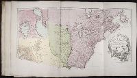
Anville, Jean Baptiste Bourguignon d', 1697-1782 Haye, G. de la
Published / Created:
avec privilege 1748
Call Number:
2003 Folio 85
Image Count:
1
Description:
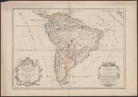
Hand colored., 2003 Folio 85: No. 43 of 45 maps bound together with binder’s spine title: Atlas of America, Bookplate: Robinson. Bookplate of Paul Mellon, Relief shown pictorially., and Scale [ca. 1:2,500,000]
"Dedié au Roy parson très humble, très obeissant, très fidele sujet et serviteur Hubert Jaillot geographe de sa Majesté.", Appears in Jaillot's Atlas françois., Hand colored borders. Sheet measures 54.2 x 77.6 cm., Includes eight bar scales., Prime meridian: Ferro., Relief shown pictorially., and Watermark.
Publisher:
Chez H. Iaillot joignant les Grands Augustins aux deux Globes avec privilege du Roy, pour vignt ans,
Subject (Geographic):
South America--Maps--Early works to 1800
Subject (Name):
Albany Institute Stamp, Cordier, Louis, -1711, engraver, and Jaillot, Alexis Hubert, 1632?-1712. Atlas françois
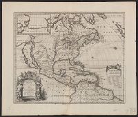
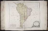
BEIN 2003 Folio 85: No. 42 of 45 maps bound together with binder's spine title: Atlas of America; ms. table of contents. Bookplate: Robinson. Bookplate of Paul Mellon., Hand colored., par le Sr. Robert de Vaugondy, fils de Mr. Robert, geographe ordinaire du roy., Relief shown pictorially., and Scale [ca. 1:17,000,000]
Covers area from northern South America to Greenland and includes the British Isles and the Azores., McLaughlin third state, with Lake Ontario shaded. Mounted on board. Sheet measures 47 x 61 cm. Ms. nos. on recto: 42, 28., Relief shown pictorially., and Shows C
Publisher:
Chez l'autheur, et chez Pierre Mariette, rue S. Iacques a l'Esperāce,
Subject (Geographic):
North America--Maps--Early works to 1800
Subject (Name):
Mariette, Pierre, 1603-1657 and Peyrounin, A., engraver
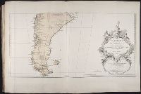
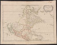
Appeared in Guillaume Sanson's Cartes générales de toutes les parties du monde., Cross collection no. 20., Differs from the 1650 Sanson map in its detail of the Gulf of California and its labeling of oceans--LVA web site., Imperfect: mutilated, with some loss of text. Mounted on linen., No. 1 of 3 maps mounted on linen., Relief shown pictorially., Shows California as an island. Includes the Southwest and Mexico., and Watermark.
Publisher:
Chez Pierre Mariette, ruë St. Jacques à l'Espera[n]ce, avec privilege de Sa Mai[es]té pour 20-äns,
Subject (Geographic):
North America--Maps--Early works to 1800
Subject (Name):
Mariette, Pierre, 1634-1716 and Sanson, Guillaume. Cartes générales de toutes les parties du monde
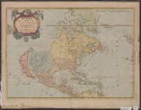
Appeared in Guillaume Sanson's Cartes générales de toutes les parties du monde., Imperfect: mutilated, with some loss of text. Mounted on linen. Sheet measures 43 x 59 cm. Cross collection no. 20. No. 1 of 3 maps mounted on linen., Mounted on cardboard. Sheet measures 46.3 x 59.8 cm. Cross collection no. 141., Relief shown pictorially., Shows California as an island. Includes the Southwest and Mexico., and Watermark.
Publisher:
Chez Pierre Mariette, ruë St. Jacques à l'Espera[n]ce, avec privilege de Sa Mai[es]té pour 20-äns,
Subject (Geographic):
North America--Maps--Early works to 1800
Subject (Name):
Mariette, Pierre, 1634-1716 and Sanson, Guillaume. Cartes générales de toutes les parties du monde