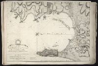
Also appeared in Faden's [General atlas. London : William Faden, 1811?]., In cartouche above title: The Roman obsidional crown, Parcere subjectis et debellare superbos., No. 15 of 43 maps bound together in composite atlas., Oriented with north toward right., Relief shown by hachures; depths by soundings., Scale [ca. 1:24,700]., and Shows ocean currents, buildings, forts, fields, magnetic declination, etc.
Publisher:
William Faden
Subject (Geographic):
Gibraltar --History --Siege, 1779-1783 --Maps --Early works to 1800, Gibraltar --Maps --Early works to 1800, and Gibraltar, Bay of (Spain) --Maps --Early works to 1800
British & Spanish territories according to the treaty of 1784
Description:
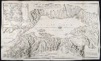
For a description of the second and third states see Stevens and Tree, Comparative Cartography, Map Collectors' Circle (1967)., Includes historical notes and a color key., Includes text., No. 40 of 43 maps bound together in composite atlas., Prime meridian: London., Relief shown pictorially., Scale [ca. 1:6,750,000]., and Shows numerous boundary changes.
Publisher:
Willm. Faden
Subject (Geographic):
United States --Boundaries --Maps --Early works to 1800 and United States --Maps --Early works to 1800
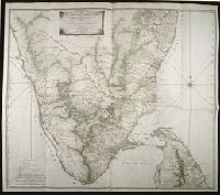
Map with relief shown pictorially, by hachures, and bathymetric soundings., No. 32 of 43 maps bound together in composite atlas., and Scale [ca. 1: 720 000].
Publisher:
Printed for Wm. Faden
Subject (Geographic):
India, South --History, Military --Maps --Early works to 1800