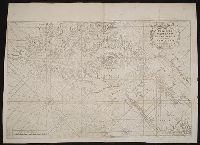
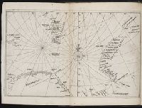
The English pilot: describing the West-India navigation, from Hudson's-Bay to the river Amazones
Image Count:
2
Subject (Geographic):
Atlantic Ocean --Maps --Early works to 1800, Maryland --Maps --Early works to 1800, New Jersey --Maps --Early works to 1800, and Virginia --Maps --Early works to 1800
Subject (Topic):
Navigation --Early works to 1800, Pilot guides --Atlantic Coast (U.S.) --Early works to 1800, and Pilot guides --Caribbean Area --Early works to 1800
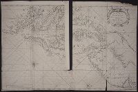
The English pilot: describing the sea-coasts, capes, head-lands, rivers, bays, roads, havens
Image Count:
1
Description:
Most maps numbered in pencil on verso, some on recto.
Subject (Geographic):
Atlantic Ocean --Maps --Early works to 1800, Maryland --Maps --Early works to 1800, New Jersey --Maps --Early works to 1800, and Virginia --Maps --Early works to 1800
Subject (Topic):
Navigation --Early works to 1800, Pilot guides --Atlantic Coast (U.S.) --Early works to 1800, and Pilot guides --Caribbean Area --Early works to 1800
Collection Created:
London : Printed for John Thornton, at the sign of the England, Scotland, and Ireland, in the Minories, and Richard Mount, at the Postern on Tower-Hill, 1698London : Printed for John Thornton, at the sign of the England, Scotland, and Ireland, in the Minories, and Richard Mount, at the Postern on Tower-Hill, 1698
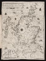
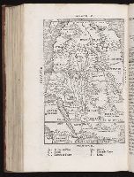
Kort beskrifning om provincien Nya Swerige uti America : som nu foertjden af the Engelske kallas
Image Count:
1
Description:
Between p. 52 & p. 53., Engraved by Holm, Thomas Campanius, ca. 1670-1702., and Teaching resource: Professor John Mack Faragher, History 141: The American West.
Subject (Geographic):
New England --Maps --Early works to 1800, United States --Maps --Early works to 1800, and Virginia --Maps --Early works to 1800
Collection Created:
Stockholm : Tryckt uti Kongl. boktr. hos S. Wankijfs ankia, med egen bekostnad, af J. H. Werner, 1702
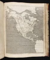
Descriptio ac delineatio geographica detectionis freti, sive, transitus ad occasum supra terras
Image Count:
1
Description:
Bound in after p. [40]., Map has water stain on recto in upper right corner., Printed on recto in lower right corner: F., and Scale [ca. 1:10,000,000].
Subject (Geographic):
Barents Sea --Maps --Early works to 1800. and Norwegian Sea --Maps --Early works to 1800
Collection Created:
Amsterodami Ex officina Hesse lij Gerardi. Anno 1613
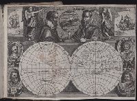
Journal ou relation exacte du voyage de Guill Schouten
Image Count:
1
Description:
Bound in after p. [8]., Busts of various explorers depicted around edges of map., Four small areas with stains on verso., Scale not given., and Western hemisphere of North and South America hand colored.
Subject (Topic):
Oceania --Discovery and exploration --Early works to 1800, Voyages around the world --Early works to 1800, and World maps --Early works to 1800
Collection Created:
A Paris : chez M. Gobert, au Palais en la gallerie des prisonniers, et les cartes, chez M. Tauernier, graueur du roy, demeurant au pont Marchand, 1618