Geographical, historical, political, philosophical and mechanical essays : the first, containing an
Image Count:
1
Resource Type:
Maps, Atlases & Globes
Description:
This second issue of the second edition includes the original map with title: A general map of the middle British colonies in America; viz. Virginia, Ma`riland, De`laware, Pensilvania, New-Jersey, New-York, Connecticut, and Rhode Island: of Aquanishuonigy
Subject (Geographic):
Erie, Lake., Middle Atlantic States--Maps., Ohio River Valley--Maps., and Ontario, Lake (N.Y. and Ont.)
Collection Created:
Philadelphia: Printed by B. Franklin, and D. Hall., MDCCLV [1755]
Anville, Jean Baptiste Bourguignon d', 1697-1782 Chapman, Thomas, fl. 1790-1803 Neele, Samuel John, 1758-1824, engraver Pauw, Cornelius, 1739-1799. Philosophical dissertations on the Egyptians and Chinese
Published / Created:
Jany. 1st, 1795.
Call Number:
1977 Folio 177
Image Count:
2
Resource Type:
Maps, Atlases & Globes
Description:
"Neele, sculpt.", Ms. note at head of title: De Pauw. Sheet measures 50.7 x 63.8 cm. No. 15 of 34 maps bound together., Prime meridians: Ferro., Relief shown pictorially., and Watermark.
Electorate of Brunswick-Luneburg with its dependencies
Description:
Imperfect: torn along fold, with some loss of text. Sheet measures 75.0 x 62.4 cm. No. 30 of 34 maps bound together., Inset map: Plan of the battle of Minden on the 1st of August 1759., Prime meridian: Ferro., and Relief shown pictorially.
Jefferson, Thomas, 1743-1826 Jefferson, Thomas, 1743-1826. Notes on the state of Virginia Neele, Samuel John, 1758-1824, engraver Stockdale, John, 1749?-1814
Published / Created:
1787
Call Number:
1977 Folio 177
Image Count:
2
Resource Type:
Maps, Atlases & Globes
Description:
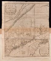
"The country on the eastern side of the Alleganey Mountains, is taken from Fry and Jefferson's Map of Virginia and Scull's Map of Pennsylvania ... that on the western side of the Alleganey, is taken from Hutchins ... additions have been made, where they could be made on sure ground.", From the author's Notes on the State of Virginia. 1787., Prime meridian: Philadelphia., Relief shown pictorially and by hachures., Sheet measures 66.3 x 60.3 cm. No. 1 of 34 maps bound together., and Shows boundaries.
Carleton, Osgood, 1742-1816 Doolittle, Amos, 1754-1832, engraver Sullivan, James, 1744-1808. History of the district of Maine Thomas & Andrews
Published / Created:
1795
Call Number:
1977 Folio 177
Image Count:
2
Resource Type:
Maps, Atlases & Globes
Description:
In upper margin: Engraved for Judge Sullivan's History of the district of Maine., Includes references to land grants., Inset: [Southeastern Maine]. Scale [ca. 1:337,920]., Prime meridian: Washington, D.C., Relief shown by hachures., Sheet measures 54.0 x 44 cm. No. 11 of 34 maps bound together., and Shows town and county boundaries.
Publisher:
Thomas & Andrews,
Subject (Geographic):
Maine--Administrative and political divisions--Maps--Early works to 1800 and Maine--Maps--Early works to 1800
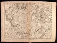
Bar scales given in "great French leagues," "common French leagues," and "British miles"., Prime meridian: Paris., Relief shown pictorially., Sheet measures 55.6 x 73.6 cm. No. 16 of 34 maps bound together., and Watermark.
Publisher:
Printed for Robert Sayer,
Subject (Geographic):
France--Administrative and political divisions--Maps--Early works to 1800 and France--Maps--Early works to 1800
Crépy, Etienne Louis, printer Fricx, Eugène-Henri, d. 1733 Fricx, Eugène-Henri, d. 1733. Cartes des provinces des Pays Bas
Published / Created:
[1743]
Call Number:
1977 Folio 177
Image Count:
2
Resource Type:
Maps, Atlases & Globes
Description:
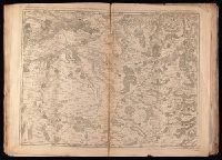
"No. 7" in lower right corner., Bar scales given in "echelle de deux Lieues et demie com[m]une de France" and "echelle de deux Lieues de Brabant"., From Fricx's Cartes des provinces des Pays Bas, 1744., Relief shown by hachures., Sheet measures 54.7 x 73.6 cm. No. 17 of 34 maps bound together., and Watermark.
Crépy (Firm) Fricx, Eugène-Henri, d. 1733 Fricx, Eugène-Henri, d. 1733. Cartes des provinces des Pays Bas
Published / Created:
1743
Call Number:
1977 Folio 177
Image Count:
2
Resource Type:
Maps, Atlases & Globes
Description:
"No. 13" in lower right corner, outside of neat line., Bar scales given in "echelle de deux lieues et demie communes de France" and "echelle de deux lieues de Brabant"., From Fricx's Cartes des provinces des Pays Bas, 1744., Prime meridian: Ferro., Relief shown by hachures., Sheet measures 55.3 x 72.3 cm. No. 33 of 34 maps bound together., and Watermark.
Publisher:
Chez Crepy rue S. Jacques a limage S. Pierre,
Subject (Geographic):
Nord-Pas-de-Calais (France)--Maps--Early works to 1800