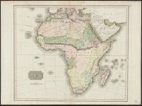
Also appeared in Kitchin's General atlas describing the whole universe. London : Printed for Robert Sayer, [1780]., By S. Boulton ; and also a summary description relative to the trade and natural produce, manners and customs of the African continent and islands., Insets: A particular chart of the Gold Cost. -- Azores or Western Islands., No. 35 of 43 maps bound together in composite atlas., Scale [ca. 1:8,500,000]., Sheets pasted together to create 1 map on 2 sheets., and With descriptive text.
Publisher:
Printed for Robert Sayer
Subject (Geographic):
Africa --Maps --Early works to 1800 and Ghana --Maps --Early works to 1800
Bottom margin: Drawn and engraved for Thomson's New General Atlas., Printed in upper right margin: No. 47., Relief shown pictorially., and Shows boundaries, rivers, deserts, caravan routes, and principal settlements, with unexplored areas.
Subject (Geographic):
Africa--Maps
Subject (Name):
Neele & Son and Thomson, John, geographer. New general atlas
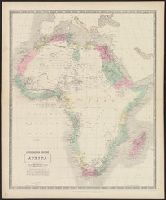
Appears in Hall's New general atlas ... [London : Printed for Longman, Rees, Orme, Brown and Green, 1830], pl. 37., Lower left margin: 37., Relief shown by hachures., Stamp on verso: Bradford Library., and Upper left margin: XXXVII.
Publisher:
Published by Longman, Orme, & Co., Paternoster Row,
"J. & G. Menzies sculpt.", From Thomson's New general atlas, 1817., Hand col. Sheet measures 53 x 69 cm., Plate affixed in upper right margin: No. 47., Relief shown pictorially., and Shows boundaries, rivers, deserts, caravan routes, and principal settlements, wit
Publisher:
J. Thomson,
Subject (Geographic):
Africa--Maps
Subject (Name):
J. & G. Menzies and Thomson, John, geographer. New general atlas
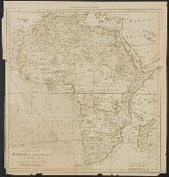
Includes "reference to European possessions" (British, Italian, French, German, Portugese, Spanish, Belgian)., Inset maps: [1.] Alexandria -- [2.] Cape Verde Islands -- [3.] Madeira -- [4.] Canary, Lower right margin: Africa 109., and Text on verso: Africa 109.