Skip to search
Skip to main content
Skip to first result
Search
You Searched For
Extent of Digitization
Completely digitized
Publication Place
Paris :
New Search
Search Results
Published / Created:
1780
Call Number:
755 1780C
Container / Volume:
BRBL_00433
Image Count:
1
Resource Type:
Maps, Atlases & Globes
Description:
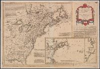
Inset: Carte de l'Ocean Occidental ... shows Territory covered by early United States. and Preliminary record.
Publisher:
Moithey,
Subject (Geographic):
Canada--Maps--Early works to 1800 and East (U.S.)--Maps--Early works to 1800
Found in:
Beinecke Rare Book and Manuscript Library > Carte Nouvelle des possessions Angloises en Amerique ... traduite de l'Anglois d'après Thos. Jefferys, revue et corrigée par M. Moithey ... 1780.
Published / Created:
[1750?]
Call Number:
3897 1750
Container / Volume:
BRBL_00183
Image Count:
1
Resource Type:
Maps, Atlases & Globes
Description:
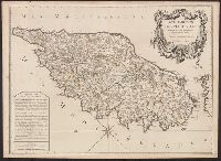
Text on margin.
Publisher:
Chez Daumont,
Subject (Geographic):
Corsica (France)--Maps--Early works to 1800
Found in:
Beinecke Rare Book and Manuscript Library > Carte Particuliere de L'Isle de Corse ... Dezauche Sculp Par le S. Pruvost I.G.
Published / Created:
[1898?]
Call Number:
38 1898
Container / Volume:
BRBL_00155
Image Count:
1
Resource Type:
Maps, Atlases & Globes
Publisher:
E. Lanée,
Subject (Geographic):
France--Maps
Found in:
Beinecke Rare Book and Manuscript Library > Carte Physique, Politique et Administrative de la France, avec le tracé des Chemins de Fer, sous la direction de L. Bonnefont ... Dressée par A. Vuillemin.
Published / Created:
[1849?]
Call Number:
38345 1849
Container / Volume:
BRBL_00178
Image Count:
1
Resource Type:
Maps, Atlases & Globes
Publisher:
Engelmann & Comp.,
Subject (Geographic):
Bas-Rhin (France)--Maps
Found in:
Beinecke Rare Book and Manuscript Library > Carte Physique, Statisque, Administrative et routére du departement du Haut-Rhin (Haute Alsace) dressée par J. G. Heck ...
Published / Created:
[1904?]
Call Number:
335 1904
Container / Volume:
BRBL_00086
Image Count:
1
Resource Type:
Maps, Atlases & Globes
Publisher:
A. Taride, Editeur,
Subject (Geographic):
Belgium--Maps
Found in:
Beinecke Rare Book and Manuscript Library > Carte Pour Cyclistes & Automobiles de la Belgique Section est.
Published / Created:
1749
Call Number:
85 1749
Container / Volume:
BRBL_00636
Image Count:
1
Resource Type:
Maps, Atlases & Globes
Publisher:
chez Mr. Bellin,
Subject (Geographic):
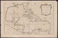
Mexico, Gulf of--Maps--Early works to 1800
Found in:
Beinecke Rare Book and Manuscript Library > Carte Reduite de Golphe du Mexique et des isles de L' Amerique ...
Creator:
Published / Created:
[1928?]
Call Number:
68 1928
Container / Volume:
BRBL_00349
Image Count:
2
Resource Type:
Maps, Atlases & Globes
Description:
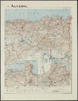
"328" in bottom right corner beneath scale statement., "Imp. Gaillac-Monrocq et Cie. 3 Rue Suger, Paris.", Includes glossary of important Arabic terms., Insets: Région d'Oran. Scale 1:450,000 -, and Shows roads, railroads, waterways, capitols, cities, and towns.
Publisher:
Taride,
Subject (Geographic):
Algeria--Maps
Subject (Name):
Peltier, Georges
Found in:
Beinecke Rare Book and Manuscript Library > Carte Taride - Algérie / Cartes Taride ; G. Peltier, cartographer.
Published / Created:
[1859?]
Call Number:
40hc 1859D
Container / Volume:
BRBL_00231
Image Count:
1
Resource Type:
Maps, Atlases & Globes
Description:
In bottom margin: 29 Avril. Les troupes Autrichiennes entrent sure le territoire Piémontais. and Includes chart: Statistique de L'Italie.
Publisher:
Monrocq,
Subject (Geographic):
Italy--Maps
Found in:
Beinecke Rare Book and Manuscript Library > Carte a vol d'oiseau pour suivre les Opérations stratégiques dans L'Italie Septentrionale.
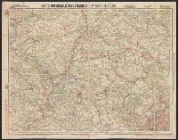
Creator:
Published / Created:
[1917]
Call Number:
38gmb P21 1907
Container / Volume:
BRBL_00171
Image Count:
2
Resource Type:
Maps, Atlases & Globes
Alternative Title:
Environs de Paris : and Nouvelle carte de France à l'usage des cyclistes et automobiles.
Description:
"11-17"--Lower right., In French., and Sheet index on panel.
Publisher:
Cartes Taride,
Subject (Geographic):
France, Northern--Maps
Subject (Name):
Cartes Taride (Firm)
Subject (Topic):
Bicycle trails--France, Northern--Maps and Roads--France, Northern--Maps
Found in:
Beinecke Rare Book and Manuscript Library > Carte automobilistes & cyclistes : environs de Paris, nord-ouest / A. Taride, editeur.
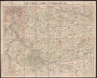
Creator:
Published / Created:
[1907]
Call Number:
38gmb P21 1907A
Container / Volume:
BRBL_00171
Image Count:
1
Resource Type:
Maps, Atlases & Globes
Alternative Title:
Environs de Paris :
Description:
"08-07"--Lower right., In French., and Sheet index on panel.
Publisher:
Cartes Taride,
Subject (Geographic):
France, Southern--Maps
Subject (Name):
Cartes Taride (Firm)
Subject (Topic):
Bicycle trails--France, Southern--Maps and Roads--France, Southern--Maps
Found in:
Beinecke Rare Book and Manuscript Library > Carte cycliste et automobile des environs de Paris : à l'échelle du 1/100.000e, sud-est / A. Taride, editeur.
Branch:v1.61.6 ,Deployed:2024-06-12T09:55:31-04:00