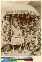
The young leader of Kwawu is depicted sitting under a large umbrella with his male attendants. The king wears a fine robe, skull cap and sandals, a bracelet on his right arm and an anklet on his left foot. Two young attendants hold long thin rods on either side of their leader.
Subject (Geographic):
Ghana
Subject (Topic):
Indigenous populations; Customs and traditions; Leadership
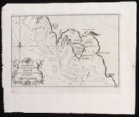
Plan of the island of Arguim [present-day Dakhlet Nouadhibou] on the Atlantic shore of Mauritania in western Africa.
Description:
"No. 2" in upper right corner; "III.D." in lower right corner., Coordinates not present on map and are approximated., From Almindelig histoirie over reiser til lands og bands ... (Kjøbenhavn: Niels Hansen Møller, 1749), a translation of Collection of voyages and travels edited by Awnsham Chruchill and Thomas Osborne., and Relief shown by hachures; depths shown by soundings.
Publisher:
[Niels Hansen Møller],
Subject (Geographic):
Arguin Island (Mauritania)--Maps--Early works t0 1800.
Subject (Name):
Churchill, Awnsham, -1728. Collection of voyages and travels. Danish., Møller, Niels Hansen, and Osborne, Thomas, -1767. Collection of voyages and travels. Danish.
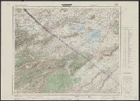
On verso: "Karte des Deutchen Reiches 1:100 000, Groβblatt 66", overstruck by black "X"., Relief shown by form lines, shading and spot heights. Depths shown on some sheets by shading., and Sheets individually subtitled with place name.
Publisher:
OKH/Gen St d H,
Subject (Geographic):
Algeria--Maps
Subject (Name):
Germany. Heer. Abteilung für Kriegskarten- und Vermessungswesen
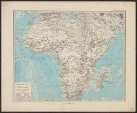
Adolf Stieler's Hand Atlas über alle Theile der Eund über das Weltgebäude. and Afrika im Massstab von 1:25.000.000
Description:
"Stieler's Hand Atlas, no. 68.", Appears in Adolf Stieler's Hand Atlas über alle Theile der Erde und über das Weltgebäude. 1881., In bottom margin: X IX., and Relief shown by hachures and spot heights.
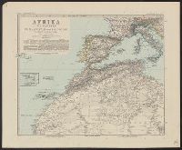
Adolf Stieler's Hand Atlas über alle Theile der Erde un über das Weltgebäude., Afrika in sechs Blättern, and Südafrika, Capland, und angrenzende Gebiete, im Massstab von 1:5.000.000.
Description:
Appears in Adolf Stieler's Hand Atlas über alle Theile der Erde und über das Weltgebäude. 1891., In top margin of each sheet, followed by consecutive numbering "no. 66" through "no. 71": Stieler's Hand Atlas., Relief shown by hachures and spot heights., and S