Search
You Searched For
Search Results
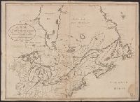
- Published / Created:
- 1774
- Call Number:
- 71 1774
- Container / Volume:
- BRBL_00726
- Image Count:
- 1
- Resource Type:
- Maps, Atlases & Globes
- Publisher:
- Printed for R. Sayer,
- Subject (Geographic):
- North America--Maps--Early works to 1800
- Found in:
- Beinecke Rare Book and Manuscript Library > A map of the British empire in North America / by Samuel Dunn, mathematician.
- Creator:
- Allen, F. D
- Published / Created:
- [1813]
- Call Number:
- 71 1813A
- Container / Volume:
- BRBL_00368
- Image Count:
- 1
- Resource Type:
- Maps, Atlases & Globes
- Description:
- Relief shown pictorially. and Shows parts of Canada and the United States.
- Publisher:
- J. Tiebout, no. 258 Water St.,
- Subject (Geographic):
- Canada--Maps and United States--Maps
- Subject (Name):
- Tiebout, John, 1772?-1826
- Found in:
- Beinecke Rare Book and Manuscript Library > A map of the British possessions in North America, including part of the United States / by F.D. Allen, 1815 ; J. Lewis sculpt.
- Published / Created:
- [1880?]
- Call Number:
- 59FAC 1880
- Container / Volume:
- BRBL_00318
- Image Count:
- 1
- Resource Type:
- Maps, Atlases & Globes
- Description:
- Inset: Simla Hill States ca. 1:1,000,000.
- Publisher:
- Thacker Spink & Co.,
- Subject (Geographic):
- India--Maps
- Found in:
- Beinecke Rare Book and Manuscript Library > A map of the Civil Divisions of India ... Trel. Saunders geogr. Stanford's Geogl. estabt. London.
- Published / Created:
- 1804
- Call Number:
- 3655 1804
- Container / Volume:
- BRBL_00144
- Image Count:
- 1
- Resource Type:
- Maps, Atlases & Globes
- Description:
- 2 copies.
- Publisher:
- Wm. Faden,
- Subject (Geographic):
- Schleswig-Holstein (Germany)--Maps
- Found in:
- Beinecke Rare Book and Manuscript Library > A map of the Dutchy of Holstein ...
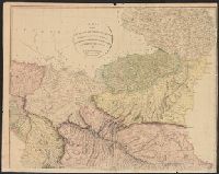
- Creator:
- Lodge, John, -1796
- Published / Created:
- 30th Septr. 1780.
- Call Number:
- 27 1780
- Container / Volume:
- BRBL_00683
- Image Count:
- 1
- Resource Type:
- Maps, Atlases & Globes
- Description:
- "Jn. Lodge, sculp." and Mounted on linen. Cross Collection 70.
- Publisher:
- Published ... by J. Bew, Pater Noster Row,
- Subject (Geographic):
- East Indies--Maps--Early works to 1800
- Subject (Name):
- Bew, John, -1793
- Found in:
- Beinecke Rare Book and Manuscript Library > A map of the East Indies [cartographic material] : from the best authorities.
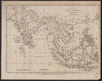
- Published / Created:
- [1708?]
- Call Number:
- 27 1708
- Container / Volume:
- BRBL_00023A
- Image Count:
- 1
- Resource Type:
- Maps, Atlases & Globes
- Description:
- Insets: Goa, Bantam, Surat, Madras, Batavia. Includes: India, Farther India and China. and Preliminary record.
- Subject (Geographic):
- Indonesia--Maps--Early works to 1800
- Found in:
- Beinecke Rare Book and Manuscript Library > A map of the East-Indies and the adjacent countries ... by H. Moll, Geog.
- Published / Created:
- 1788
- Call Number:
- 367 1788
- Container / Volume:
- BRBL_00145
- Image Count:
- 1
- Resource Type:
- Maps, Atlases & Globes
- Publisher:
- Robert Sayer,
- Subject (Geographic):
- Brandenburg--Maps--Early works to 1800
- Found in:
- Beinecke Rare Book and Manuscript Library > A map of the Electorate of Brandenburg, including Western Pomerania and the greatest part of the Dutchies of Mecklenburg and Magdeburg.
- Published / Created:
- 1804
- Call Number:
- 53 1804
- Container / Volume:
- BRBL_00284
- Image Count:
- 4
- Resource Type:
- Maps, Atlases & Globes
- Publisher:
- A. Arrowsmith,
- Subject (Geographic):
- Middle East--Maps
- Found in:
- Beinecke Rare Book and Manuscript Library > A map of the Environs of Constantinople ... A. Arrowsmith 1801 and 1804.
- Published / Created:
- [1792?]
- Call Number:
- 771 D37 1792F
- Image Count:
- 1
- Resource Type:
- Maps, Atlases & Globes
- Alternative Title:
- Map of the Franklin patent
- Description:
- Coordinates not present on map and are approximated. and North oriented towards the upper left.
- Subject (Geographic):
- Delaware County (N.Y.)--Maps.
- Subject (Topic):
- Real property--New York (State)--Delaware County--Maps.
- Found in:
- Beinecke Rare Book and Manuscript Library > A map of the Franlin patient.