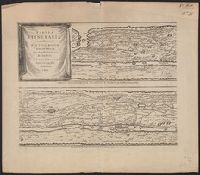
Horn, Georg, 1620-1670 Jansson, Jan, 1588-1664. Accuratissima Orbis antiqui delineatio... [1652?] Jansson, Jan, 1588-1664. Novus Atlas Peutinger, Konrad, 1465-1546 or 7 Welser, Marcus, 1558-1614
Published / Created:
1652?]
Call Number:
314 1654
Container / Volume:
BRBL_00038
Image Count:
4
Resource Type:
Maps, Atlases & Globes
Alternative Title:
Peutinger table. and Tabula itineraria ex illustri Peutingerorum
Description:
From: Accuratissima Orbis antiqui delineatio...by J. Jansson [1652?], Jansson's Peutinger table was reprinted in various editions of Accuratissima Orbis antiqui delineatio and in later editions edited by Georg Horn. Map also appeared in, and Lanman collection.
Publisher:
prostant apud Joannem Janssonium,
Subject (Geographic):
Roman Empire Maps--Early works to 1800
Subject (Topic):
Roads, Roman--Maps--Early works to 1800 and World maps--Early works to 1800
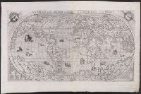
Decorated with sea monsters, mermaids, exotic animals, and cannibals, this wood cut map provides a marked contrast to the simplistic diagrams considered the earliest printed world maps. While the latter presented a world view based in Judeo-Christian theo
Alternative Title:
Typus cosmographicus universalis and Typvs cosmographicvs vniversalis
Description:
Appears in Johann Huttich's Novus orbis regionum. Basel. 1532. and Relief shown pictorially.
Publisher:
[publisher not identified],
Subject (Name):
Holbein, Hans, 1497-1543 and Huttich, Johann, 1480?-1544. Novus orbis regionum.
Possibly from Münster's 1545 edition of Ptolemy's Geographia [Basel : Heinrich Petri, 1545]. and Sheet measures 31.5 x 39 cm. Stamp on verso: Karpinski-von Wieser Map Collection.
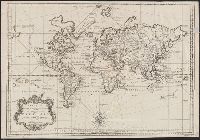
Vniversale descrittione di tvtta la terra conoscivta fin qvi
Description:
From: [Italian composite atlases]., Map is made from a new copper plate which is a close copy of Paolo Forlani's world map, which Forlani copied from Giacomo Gastaldi's prototype world map of 1546., Relief shown pictorially., and There are winged cherub heads in the top two spandrels.
Publisher:
Donato Bertelli,
Subject (Name):
Forlani, Paolo and Gastaldi, Giacomo, ca. 1500-ca. 1565
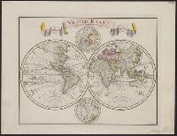
Cross collection no. 40., In lower right corner: "Tom VII No. 22.", Prime meridian: Paris., Relief shown pictorially., and Scale measured at center of hemisphere.
Publisher:
s.n.],
Subject (Name):
Maurepas, Jean-Frédéric Phélypeaux, comte de, 1701-1781
"C. Sepp del. et sculps. 1744.", Cross collection no. 37., In Dutch., Includes 2 smaller circular polar maps, and decorative cartouche., Mounted on linen., Ms. note at head of map: No. J., Relief shown pictorially., and Scale measured at center of hemisphere.
"Photolithographed copy of Gerard Mercator's Mapamundi of 1538 from an original engraving in the library of the American Geographical Society.", Relief shown pictorially., and Title devised by cataloger.
Publisher:
Julius Bien & Co., photo-lith,
Subject (Geographic):
World--Maps--Early works to 1800
Subject (Name):
American Geographical Society of New York and Julius Bien & Co
Subject (Topic):
Early maps, Early maps--Facsimiles, World maps, and World maps--Early works to 1800
Cordiform projection., From: "Claudii Ptholemaei Alexandrini liber geographiae cum tabulis...", From: Clavdii Ptholemaei Alexandrini Liber geographiae cvm tabvlis...1511., Lanman collection; dgvmp2008., Map is printed in two colors, red and black., Outer map border shows decorative windheads and zodiacal signs., The author's name is often given as Bernard Sylvanus (see Shirley entry 32, plate 35) or Bernardus Sylvanus., and Title supplied by cataloger.
Publisher:
Per Iacobum Pentium de Leucho,
Subject (Name):
Pencio, Jacopo, active 1486-1530 and Ptolemy, active 2nd century. Geographia