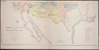
Includes "Note" and "Authorities.", Incorporates note and surveys added after Jan. 8, 1858., Relief shown by hachures and spot heights., and Shows Indian tribal locations, military posts, routes and dates of expeditions and surveys.
Publisher:
War Dept.,
Subject (Geographic):
West (U.S.)--Maps
Subject (Name):
Siebert, Selmar and United States. War Dept
Subject (Topic):
Pacific railroads--Explorations and surveys--Maps and Railroads--West (U.S.)--Maps
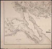
Includes list of "Authorities" and inset "Territory of Alaska" (scale 1:9,000,000)., Relief shown by hachures and spot heights., and Shows routes and dates of expeditions and surveys.
Publisher:
War Dept.,
Subject (Geographic):
West (U.S.)--Maps
Subject (Name):
United States. War Dept and Warren, Gouverneur Kemble, 1830-1882
Subject (Topic):
Pacific railroads--Explorations and surveys--Maps and Railroads--West (U.S.)--Maps