Search
You Searched For
Search Results
- Creator:
- Cóvens et Mortier
- Published / Created:
- ca. 1730-ca. 1800]
- Call Number:
- 1973 Folio 71
- Image Count:
- 1
- Resource Type:
- Maps, Atlases & Globes
- Found in:
- Beinecke Rare Book and Manuscript Library > [Atlas nouveau contenant toutes les parties du monde ou sont exactement marqués les empires, monarchies, royaumes, états, republiques &c. Le tout recueilli par les meilleurs geógraphes.]
- Creator:
- Moll, Herman, d. 1732
- Published / Created:
- [178-?]
- Call Number:
- 1973 Folio 113
- Image Count:
- 2
- Resource Type:
- Maps, Atlases & Globes
- Found in:
- Beinecke Rare Book and Manuscript Library > Atlas minor: or A new and curious set of sixty two maps, in which are shewn all the empires, kingdoms, countries, states in all the known parts of the earth ... by Herman Moll ...
- Creator:
- Des Barres, Joseph F. W. (Joseph Frederick Wallet), 1722-1824
- Published / Created:
- 1775?-1781?]
- Call Number:
- 1983 Folio 25
- Image Count:
- 3
- Resource Type:
- Maps, Atlases & Globes
- Found in:
- Beinecke Rare Book and Manuscript Library > [The Atlantic Neptune : published for the use of the Royal Navy Great Britain / by Joseph F.W. Des Barres, esq.].
- Creator:
- Bowles, Carington, 1724-1793
- Published / Created:
- [1766]
- Call Number:
- ByzL 79t
- Collection Title:
- A new and accurate history and survey of London, Westminster, Southwark, and places adjacent
- Image Count:
- 1
- Resource Type:
- Maps, Atlases & Globes
- Found in:
- Beinecke Rare Book and Manuscript Library > The London guide, or, a pocket plan of the cities of London & Westminster and Borough of Southwark; with the new buildings, &c. to the present year
- Published / Created:
- 1850
- Call Number:
- 1976 Folio 96
- Collection Title:
- A new universal atlas containing maps of the various empires, kingdoms, states and republics of the
- Image Count:
- 1
- Resource Type:
- Maps, Atlases & Globes
- Found in:
- Beinecke Rare Book and Manuscript Library > 10. Map of Connecticut
- Published / Created:
- 1846
- Call Number:
- 1976 Folio 93
- Collection Title:
- A new universal atlas containing maps of the various empires, kingdoms, states and republics of the
- Image Count:
- 1
- Resource Type:
- Maps, Atlases & Globes
- Found in:
- Beinecke Rare Book and Manuscript Library > 9. Connecticut
- Published / Created:
- [1808]
- Call Number:
- In W890 Zz808
- Collection Title:
- The history of the rise, progress, and accomplishment of the abolition of the African slave-trade
- Image Count:
- 1
- Resource Type:
- Maps, Atlases & Globes
- Found in:
- Beinecke Rare Book and Manuscript Library > [Untitled map of abolition of the slave trade]
- Creator:
- Friesen, F
- Published / Created:
- 1808
- Call Number:
- Folio Q115 H84 1B
- Collection Title:
- Atlas geographique et physique des regions equinoxiales du nouveau continent, fonde sur des
- Image Count:
- 1
- Resource Type:
- Maps, Atlases & Globes
- Found in:
- Beinecke Rare Book and Manuscript Library > Limite inferieure des Neiges perpetuelles a differentes Latitudes
- Published / Created:
- 1817
- Call Number:
- Folio Q115 H84 1B
- Collection Title:
- Atlas geographique et physique des regions equinoxiales du nouveau continent, fonde sur des
- Image Count:
- 1
- Resource Type:
- Maps, Atlases & Globes
- Found in:
- Beinecke Rare Book and Manuscript Library > Tableau physique des Ils Canaries. Geographie des plantes du Pic de Teneriffe
- Published / Created:
- 1820
- Call Number:
- Folio Q115 H84 1B
- Collection Title:
- Atlas geographique et physique des regions equinoxiales du nouveau continent, fonde sur des
- Image Count:
- 1
- Resource Type:
- Maps, Atlases & Globes
- Found in:
- Beinecke Rare Book and Manuscript Library > Profit du Chemin de Carthagene des Indes au Plateau de Santa Fe de Bogata. pl. 6
- Published / Created:
- 1813
- Call Number:
- Folio Q115 H84 1B
- Collection Title:
- Atlas geographique et physique des regions equinoxiales du nouveau continent, fonde sur des
- Image Count:
- 1
- Resource Type:
- Maps, Atlases & Globes
- Found in:
- Beinecke Rare Book and Manuscript Library > Carte du Cours de Rio Apure et d'une Partie de la Chaine des Montaignes de la Nouvelle Grenade, dressee par Alexandre de Humboldt. pl. 17
- Published / Created:
- undated
- Call Number:
- Folio Q115 H84 1B
- Collection Title:
- Atlas geographique et physique des regions equinoxiales du nouveau continent, fonde sur des
- Image Count:
- 1
- Resource Type:
- Maps, Atlases & Globes
- Found in:
- Beinecke Rare Book and Manuscript Library > Carte du Rio Grande de la Magdalena depuis le 4 [degrees] Latitude jusqu'a son embouchure. No. 24
- Published / Created:
- 1808
- Call Number:
- Folio Q115 H84 3A
- Collection Title:
- Atlas geographique et physique du royaume de la Nouvelle-Espagne, fonde sur des observations
- Image Count:
- 1
- Resource Type:
- Maps, Atlases & Globes
- Found in:
- Beinecke Rare Book and Manuscript Library > Carte de la Vallee de Mexico et des Montagnes Voisines esquissee sur les Lieux en 1804, par Don Louis Martin redigee et corrigee en 1807 d'apres les operations trigonometriques de Don Joaquin Velasquez et d'apres les observations astronomiques et les mesu
- Published / Created:
- 1807-08
- Call Number:
- Folio Q115 H84 3A
- Collection Title:
- Atlas geographique et physique du royaume de la Nouvelle-Espagne, fonde sur des observations
- Image Count:
- 1
- Resource Type:
- Maps, Atlases & Globes
- Found in:
- Beinecke Rare Book and Manuscript Library > Tableau physique de la pente Orientale du Plateau de la Nouvelle Espagne (Chemin de Mexico a Veracruz par Puebla et Xalapa.) Dresse d'apres des mesures barometriques et trigonometriques, prises en 1804 par Mr. de Humboldt. pl. 12
- Published / Created:
- 1805-07
- Call Number:
- Folio Q115 H84 3A
- Collection Title:
- Atlas geographique et physique du royaume de la Nouvelle-Espagne, fonde sur des observations
- Image Count:
- 1
- Resource Type:
- Maps, Atlases & Globes
- Found in:
- Beinecke Rare Book and Manuscript Library > Tableau du Plateau central des Montagnes du Mexique, entre les 19 et 21 [degree] de Latitude boreale, (Chemin de Mexico a Guanaxuato) Dresse d'apres le Nivellement Barometrique de Mr. de Humboldt. pl. 14
- Published / Created:
- 1808
- Call Number:
- Folio Q115 H84 3A
- Collection Title:
- Atlas geographique et physique du royaume de la Nouvelle-Espagne, fonde sur des observations
- Image Count:
- 1
- Resource Type:
- Maps, Atlases & Globes
- Found in:
- Beinecke Rare Book and Manuscript Library > Profit du Canal de Huehuetoca (Desague Real.) Creuse pour preserver la Ville de Mexico du danger des Inondations. pl. 15
- Published / Created:
- [1567]
- Call Number:
- Peru Cwpr j567
- Collection Title:
- Levini Apollonii, Gandobrvgani, Mittelbvrgensis, de Peruuiae, regionis, inter Noui Orbis prouincias
- Image Count:
- 1
- Resource Type:
- Maps, Atlases & Globes
- Found in:
- Beinecke Rare Book and Manuscript Library > Brevis, exactaq totivs novi orbis et Pervviae regionis descriptio recens edita
- Published / Created:
- [1560]
- Call Number:
- Peru Cwpr j553ci
- Collection Title:
- La prima parte dell historie del Perv. Dove si tratta lordine delle prouincie, delle citta nuoue in
- Image Count:
- 1
- Resource Type:
- Maps, Atlases & Globes
- Found in:
- Beinecke Rare Book and Manuscript Library > Brevis exactaq totivs novi orbis eivsq; insvlarvm descriptio recens a ioan bellero edita
- Published / Created:
- [1490]
- Call Number:
- 1978 Folio 114
- Collection Title:
- Cosmographia. [Translated into Latin by Jacobus Angelus, and edited by Nicolaus Germanus.]
- Image Count:
- 1
- Resource Type:
- Maps, Atlases & Globes
- Found in:
- Beinecke Rare Book and Manuscript Library > [Map depicting Europe, North Africa, the Middle East and Asia].
- Published / Created:
- [1540]
- Call Number:
- E33 +540P
- Collection Title:
- Geographia vniversalis, vetvs et nova complectens Clavdii Ptolemaei Alexandrini enarrationis libros
- Image Count:
- 1
- Resource Type:
- Maps, Atlases & Globes
- Found in:
- Beinecke Rare Book and Manuscript Library > Tabula Europae IX
- Creator:
- New Haven (Conn.). East Rock Park Commission
- Published / Created:
- 1882 May
- Call Number:
- Za M692 +882
- Collection Title:
- A report to the commissioners on lay-out of East Rock Park / by Donald G. Mitchell, LL.D
- Image Count:
- 1
- Resource Type:
- Maps, Atlases & Globes
- Found in:
- Beinecke Rare Book and Manuscript Library > Hints for the lay-out of East-Rock Park
- Call Number:
- 1989 +19
- Collection Title:
- A collection of voyages and travels, some now first printed from original manuscripts, others now
- Image Count:
- 1
- Resource Type:
- Maps, Atlases & Globes
- Found in:
- Beinecke Rare Book and Manuscript Library > A chart and map of the Gold Coast of Guinea from Rio da Corsa to Ro da Volta. vol. V [5], pl. K
- Published / Created:
- 1722
- Call Number:
- Zc52 +722pe
- Collection Title:
- Derrotero de la expedicion en la provincia de los Texas, nuevo reyno de Philipinas, que de orden
- Image Count:
- 2
- Resource Type:
- Maps, Atlases & Globes
- Found in:
- Beinecke Rare Book and Manuscript Library > Plan del Presidio dens de los Dolores
- Published / Created:
- 1722
- Call Number:
- Zc52 +722pe
- Collection Title:
- Derrotero de la expedicion en la provincia de los Texas, nuevo reyno de Philipinas, que de orden
- Image Count:
- 2
- Resource Type:
- Maps, Atlases & Globes
- Found in:
- Beinecke Rare Book and Manuscript Library > Presidio de n.s. de Loreto en la Bahia
- Published / Created:
- 1739
- Call Number:
- WeInd Ehc 739
- Collection Title:
- A description of the Windward Passage, and Gulf of Florida, with the course of the British trading
- Image Count:
- 1
- Resource Type:
- Maps, Atlases & Globes
- Found in:
- Beinecke Rare Book and Manuscript Library > A chart of the Bahamas Islands with a description of the Gulf of Florida and Windward passage &c. referr'd from the figures here set down, to the general index annexed ... by J.C
- Published / Created:
- [ca. 1675]
- Call Number:
- GEN MSS VOL 4
- Collection Title:
- Atlas of the world
- Image Count:
- 1
- Resource Type:
- Maps, Atlases & Globes
- Found in:
- Beinecke Rare Book and Manuscript Library > Die gantse welt
- Call Number:
- Zc52 843Leb
- Collection Title:
- The legion of liberty
- Image Count:
- 1
- Resource Type:
- Maps, Atlases & Globes
- Found in:
- Beinecke Rare Book and Manuscript Library > Moral map of U.S., Jan. 1837
- Creator:
- Bry, Theodor de, 1528-1598
- Call Number:
- 1976 Folio 110
- Collection Title:
- The mariners mirrovr wherin may playnly be seen the courses, heights, distances, depths, sounding
- Image Count:
- 1
- Resource Type:
- Maps, Atlases & Globes
- Found in:
- Beinecke Rare Book and Manuscript Library > The sea coastes of the landes of Poyctou and Bordeaux ...as they shew and appeare, when you sayle there alongst betweene Picquelier and the River of Bordeaux called the Garonne
- Creator:
- Clark, William, 1770-1838
Lewis, Samuel, 1753 or 4-1822
- Published / Created:
- [ca. 1814]
- Call Number:
- Zc10 814Le
- Collection Title:
- History of the expedition under the command of Captains Lewis and Clark, to the sources of the
- Image Count:
- 2
- Resource Type:
- Maps, Atlases & Globes
- Found in:
- Beinecke Rare Book and Manuscript Library > A map of Lewis and Clark's track, across the western portion of North America fom the Mississippi to the Pacific Ocean; by order of the Executive of the United States . In 1804, 5 & 6
- Call Number:
- 1983 Folio 50
- Collection Title:
- Atlas novus sive Tabulae geographicae totius orbis faciem : partes, imperia, regna et provincias
- Image Count:
- 2
- Resource Type:
- Maps, Atlases & Globes
- Found in:
- Beinecke Rare Book and Manuscript Library > Historia Imperii Romano-Germanici, nec non finitimarum Regionum In Mappa exhibita, ac aeri incisa a Mattheo Seutter ...
- Creator:
- Visscher, Nicolaes, 1618-1679
- Published / Created:
- anno 1653
- Call Number:
- 1983 Folio 19
- Collection Title:
- [Atlas factice of 96 maps by Blaeu, Visscher, Jansson, Hondius and others]
- Image Count:
- 2
- Resource Type:
- Maps, Atlases & Globes
- Found in:
- Beinecke Rare Book and Manuscript Library > Asiae nova descriptio / auctore Nicola. Io. Visscher
- Creator:
- Blaeu, Joan, 1596-1673. Theatrum orbis terrarum
Blaeu, Willem Janszoon, 1571-1638
Blaeu, Willem Janszoon, 1571-1638. Theatrum orbis terrarum
- Published / Created:
- [ca. 163-?]
- Call Number:
- 1983 Folio 19
- Collection Title:
- [Atlas factice of 96 maps by Blaeu, Visscher, Jansson, Hondius and others]
- Image Count:
- 2
- Resource Type:
- Maps, Atlases & Globes
- Found in:
- Beinecke Rare Book and Manuscript Library > Tvrcicvm imperivm
- Creator:
- Blaeu, Joan, 1596-1673. Theatrum orbis terrarum
Blaeu, Willem Janszoon, 1571-1638
Blaeu, Willem Janszoon, 1571-1638. Theatrum orbis terrarum
- Published / Created:
- [ca. 163-?]
- Call Number:
- 1983 Folio 19
- Collection Title:
- [Atlas factice of 96 maps by Blaeu, Visscher, Jansson, Hondius and others]
- Image Count:
- 2
- Resource Type:
- Maps, Atlases & Globes
- Found in:
- Beinecke Rare Book and Manuscript Library > Sabavdia dvcatvs, Savoye
- Creator:
- Cook, James, 1728-1779
Gulielmus Whitchurch
- Published / Created:
- 1776
- Call Number:
- 1977 +300
- Collection Title:
- A voyage towards the South pole, and round the world. Performed in His Majesty’s ships the
- Image Count:
- 1
- Resource Type:
- Maps, Atlases & Globes
- Found in:
- Beinecke Rare Book and Manuscript Library > A chart of the southern hemisphere; shewing the tracks of some of the most distinguished navigators
- Published / Created:
- 1719
- Call Number:
- Defoe 50 719db 1
- Collection Title:
- The life and strange surprizing adventures of Robinson Crusoe, of York, mariner : who lived eight
- Image Count:
- 1
- Resource Type:
- Maps, Atlases & Globes
- Found in:
- Beinecke Rare Book and Manuscript Library > A Map of the world, on wch is delineated the voyages of Robinson Cruso
- Published / Created:
- 1731
- Call Number:
- Ehdc 725
- Collection Title:
- Voyage du chevalier Des Marchais en Guinee, isles voisines, et a Cayenne, fait en 1725, 1726 & 1727
- Image Count:
- 1
- Resource Type:
- Maps, Atlases & Globes
- Found in:
- Beinecke Rare Book and Manuscript Library > Carte particuliere du Royaume de Juda
- Call Number:
- WeInd Ehc 762J
- Collection Title:
- A description of the Spanish islands and settlements on the coast of the West Indies / compiled
- Image Count:
- 1
- Resource Type:
- Maps, Atlases & Globes
- Found in:
- Beinecke Rare Book and Manuscript Library > The island of Hispaniola called by the French St. Domingo. Subject to France and Spain
- Creator:
- Dodsley, Robert, 1703-1764
Evans, Lewis, 1700?-1756.
Turner, James, d. 1759, engraver.
- Published / Created:
- 1755
- Call Number:
- 391 +1755h
- Collection Title:
- Geographical, historical, political, philosophical and mechanical essays : the first, containing an
- Image Count:
- 1
- Resource Type:
- Maps, Atlases & Globes
- Found in:
- Beinecke Rare Book and Manuscript Library > A general map of the middle British colonies in America
- Published / Created:
- Undated
- Call Number:
- 1975 2757
- Collection Title:
- El atlas abreviado, o, El nuevo compendio de la geografia universal, politica, historica, i curiosa
- Image Count:
- 1
- Resource Type:
- Maps, Atlases & Globes
- Found in:
- Beinecke Rare Book and Manuscript Library > Isles Britanniques ou sont les royaumes d'Angleterre d'Escosse et d'Irlande
- Published / Created:
- Undated
- Call Number:
- 1978 595
- Collection Title:
- El atlas abreviado, o Compendiosa geografia, del mvndo antigvo, y nvevo, segun esta oy dividido
- Image Count:
- 1
- Resource Type:
- Maps, Atlases & Globes
- Found in:
- Beinecke Rare Book and Manuscript Library > Yslas Britanicas enque se comprehenden los reynos de Ynglaterra, Escocia, e Yrlanda
- Creator:
- Visscher, Nicolaes, 1649-1702
- Published / Created:
- Undated
- Call Number:
- 1973 Folio 71
- Collection Title:
- [Atlas nouveau contenant toutes les parties du monde ou sont exactement marques les empires
- Image Count:
- 1
- Resource Type:
- Maps, Atlases & Globes
- Found in:
- Beinecke Rare Book and Manuscript Library > A new mapp of the kingdome of England, representing the princedome of Wales, and other provinces, cities, market towns, with the roads from town to town and the number of reputed miles between them, are given by inspection without scale or compass
- Published / Created:
- 1774 November 29
- Call Number:
- 1975 Folio 51
- Collection Title:
- The American atlas; or, A geographical description of the whole continent of America; wherein are
- Image Count:
- 1
- Resource Type:
- Maps, Atlases & Globes
- Found in:
- Beinecke Rare Book and Manuscript Library > A map of the most inhabited part of New England, containing the provinces of Massachusets Bay and New Hampshire, with the colonies of Conecticut and Rhode Island, divided into counties and townships: the whole composed from actual surveys and its situatio
- Published / Created:
- 1756
- Call Number:
- 1973 Folio 119
- Collection Title:
- Atlas universel, par M. Robert ... et par M. Robert de Vaugondy son fils ...
- Image Count:
- 1
- Resource Type:
- Maps, Atlases & Globes
- Found in:
- Beinecke Rare Book and Manuscript Library > Carte de la Lorraine et Du Barrois dans laquelle se trouvent la generalite de metz et autres enclaves; dresseepour la lecture du memoire de M. Durival l'aine, et dediee au Roy de Pologne Duc de Lorraine et de bar par le Sr. Robert de Vaugondy ...
- Published / Created:
- 1753
- Call Number:
- 1973 Folio 119
- Collection Title:
- Atlas universel, par M. Robert ... et par M. Robert de Vaugondy son fils ...
- Image Count:
- 1
- Resource Type:
- Maps, Atlases & Globes
- Found in:
- Beinecke Rare Book and Manuscript Library > Carte de la l'Egypte ancienne et moderne, dressee sur celle du R.P. Sicard et autres, assujielles aux observations astronomiques par le Sr. Robert de Vaugondy ...
- Creator:
- Russell, J.C
- Call Number:
- Defoe 57 W99 g816
- Collection Title:
- The Swiss family Ro
- Image Count:
- 1
- Resource Type:
- Maps, Atlases & Globes
- Found in:
- Beinecke Rare Book and Manuscript Library > Settlements of the Swiss pastor & his family in the desert island
- Creator:
- Inselin, C
- Call Number:
- 1977 Folio 114
- Collection Title:
- L’atlas curieux ou Le monde represente dans des cartes generales et particulieres du ciel et de la
- Image Count:
- 1
- Resource Type:
- Maps, Atlases & Globes
- Found in:
- Beinecke Rare Book and Manuscript Library > Bourg, chateau, et iardins de Fontaine-bleau
- Creator:
- Moll, Herman, d. 1732
- Published / Created:
- [1732]
- Call Number:
- E1015 M66 1732
- Collection Title:
- Atlas minor: or a set of sixty-two new and correct maps, of all parts of the world. All composed
- Image Count:
- 1
- Resource Type:
- Maps, Atlases & Globes
- Found in:
- Beinecke Rare Book and Manuscript Library > A general map of Great Britain and Ireland with part of Germany, Holland, Flanders, France &c. agreeable to modern history
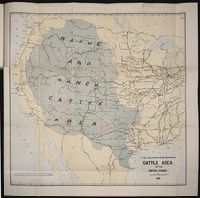
- Published / Created:
- 1884
- Call Number:
- Zc10 885up
- Collection Title:
- Range and ranch cattle
- Image Count:
- 1
- Resource Type:
- Maps, Atlases & Globes
- Found in:
- Beinecke Rare Book and Manuscript Library > The range and ranch cattle area of the United States
- Creator:
- Braun, Georg, 1540 or 1-1622
Hierat, Anton, fl.1597-1627
Hogenberg, Abraham, fl. 1608-1653
Hogenberg, Franz, d. 1590?
- Published / Created:
- 1572]-1618
- Call Number:
- 1975 Folio 41
- Image Count:
- 1
- Resource Type:
- Maps, Atlases & Globes
- Found in:
- Beinecke Rare Book and Manuscript Library > Civitates orbis terrarvm ...
- Creator:
- Alpagot, Haydar
Ayasofya Kütüphanesi. Manuscript. 2612
Kurtoğlu, Fevzi
Pekol, Fehmi
Pirı̂ Reis, d. 1554?
Türk ve İslâm Eserleri Müzesi. Manuscript. Turkish 403
- Published / Created:
- 1935
- Call Number:
- 1977 +68
- Image Count:
- 2
- Resource Type:
- Maps, Atlases & Globes
- Found in:
- Beinecke Rare Book and Manuscript Library > Kitabi bahriye / Piri Reis.