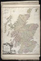
Italy divided according as its severall principalities extend, which are the territories of the Church, of the Catholick king, which contain the kingdomes of Naples, Sicily, Sardinia, and the Dukedome of Millain ... described by Sanson, corrected and amended by Will. Berry
Description:
Bar scales given in Italian miles, common leagues of Germany, great German leagues, common leagues of France, great French leagues, and common leagues of Spain., Dedicated To the most serene and most sacred majesty of Charles II ... by William Berry., No. 16 of 69 maps bound together in composite atlas., Relief shown pictorially., and Scale [ca. 1:2 300 000].
Publisher:
Sold by William Berry at the signe of the Globe between Charing-Cross and White Hall
An historical, geographical, commercial, and philosophical view of the American United States, and
Image Count:
1
Description:
Engraved by Russell, Constitution R., Grays Inn La. and Facing p. 2.
Publisher:
Publish'd as the Act directs, by H.D. Symonds, No. 20 Pater Noster Row
Subject (Geographic):
America --Description and travel, America --History --To 1810, New England --Maps --Early works to 1800, United States --Description and travel, and United States --Maps --Early works to 1800
Collection Created:
London, Printed for the editor; J. Ridgway [etc.] 1795
Mediterranean Sea divided into the eastern and western seas, subdivides into its principal parts or seas ... described by Sanson, corrected and amended by William Berry
Description:
Based on La Mer Mediterranee divisee enses Principales Parties, ou Mers by Nicolas Sanson., Dedicated To the most serene and most sacred majesty James II ... by William Berry., Ms. mathematical annotations in left margin., No. 23 of 69 maps bound together in composite atlas., Relief shown pictorially., and Scale [ca. 1:610 000].
Publisher:
Sold by William Berry at the signe of the Globe between Charing-Cross and White-Hall
Eastern old world hemisphere has imprint: London ... Dec. 1st, 1786 by William Faden., No. 2 of 43 maps bound together in composite atlas., Scale [1:60,000,000]., and Shows western and eastern hemispheres separately.
Ed. statement appears on Northern Hemisphere map only., No. 3 of 43 maps bound together in composite atlas., Relief shown pictorially., Scale [ca. 1:41,000,000. At equator]., and Shows tracks of various ocean voyages.
Publisher:
William Faden
Subject (Geographic):
Northern Hemisphere --Maps --Early works to 1800 and Southern Hemisphere --Maps --Early works to 1800