Skip to search
Skip to main content
Skip to first result
Search
You Searched For
Extent of Digitization
Completely digitized
Genre
Maps
Language
Dutch; Flemish
New Search
Search Results
Published / Created:
[1725?]
Call Number:
491 IS7 1725
Container / Volume:
BRBL_00270
Image Count:
1
Resource Type:
Maps, Atlases & Globes
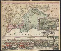
Description:
Insets: View of Constantinople with index, view through the Dardanelles to Constantinople.
Publisher:
Johann Baptist Homann ... ,
Subject (Geographic):
Thrace, Eastern (Turkey)--Maps--Early works to 1800
Found in:
Beinecke Rare Book and Manuscript Library > Accurate Vorstellung der Orientalish-Kayserlichen Haupt-und Residenz-Stadt Constantinople ... Meer-Engen, Bosphoro Thracio, und Hellesponto ...
Creator:
Published / Created:
[1667]
Call Number:
321 1667
Container / Volume:
BRBL_00054A
Image Count:
1
Resource Type:
Maps, Atlases & Globes
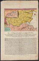
Alternative Title:
Kaerte van de rivieren van London en Rochester of Chetham
Description:
Includes inset of Medway River below Rochester, ill., and text., Relief shown pictorially., and Shows approach to England of the Dutch fleet commanded by De Ruyter on 19-23 June 1667, during the second Anglo-Dutch war.
Publisher:
Nicolaes Visscher, in de Kalverstraet, in de Visscher,
Subject (Geographic):
Medway, River (England)--Maps--Early works to 1800 and Thames Valley (England)--Maps--Early works to 1800
Subject (Name):
Ruyter, Michiel Adriaanszoon de,--1607-1676
Subject (Topic):
Anglo-Dutch War, 1664-1667--Naval operations
Found in:
Beinecke Rare Book and Manuscript Library > Afbeeldinge vande rivieren van London en Rochester.
Creator:
Published / Created:
[1925?]
Call Number:
582 J987 1665
Container / Volume:
BRBL_00314
Image Count:
1
Resource Type:
Maps, Atlases & Globes
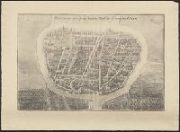
Description:
From: Monumenta cartographica I. 18.
Publisher:
[Martinus Nijhoff],
Subject (Geographic):
Phra Nakhon Si Ayutthaya (Thailand)--Maps.
Subject (Name):
Wieder, F. C. (Frederik Caspar), 1874-1943. Monumenta cartographica.
Found in:
Beinecke Rare Book and Manuscript Library > Afbeldinge der Stadt Iudiad hooft des choonincrick Siam.
Creator:
Published / Created:
[between 1641 and 1658?]
Call Number:
70 165X
Container / Volume:
BRBL_00353
Image Count:
2
Resource Type:
Maps, Atlases & Globes
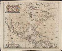
Description:
Covers North America, Cent, Dutch text on verso, with signature "Bb.", Relief shown pictorially., and State 2, first issued in 1641, according to Burden; matches description of Dutch text versions appearing in Nieuwen atlas editions 1645, '47, '52, '53, and '58.
Publisher:
excudit Ioannes Ianssonius,
Subject (Geographic):
North America--Maps--Early works to 1800
Subject (Name):
Jansson, Jan, 1588-1664. Atlas novus. Dutch
Found in:
Beinecke Rare Book and Manuscript Library > America Septentrionalis.
Creator:
Published / Created:
[1652?]
Call Number:
70 165XA
Container / Volume:
BRBL_00353
Image Count:
2
Resource Type:
Maps, Atlases & Globes
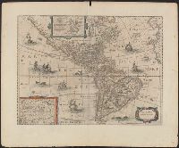
Description:
Appears in various eds. of Jansson's Nieuwen atlas., Dutch text on verso., Includes ill. of ships and sea monsters, and insets showing "Polus Arcticus" region and "Terra Australis incognita.", Relief shown pictorially., and Sheet measures 50.1 x 60.9 cm.
Publisher:
Excudit Ioannes Ianssonius,
Subject (Geographic):
America--Maps--Early works to 1800
Subject (Name):
Jansson, Jan, 1588-1664. Atlas novus. Dutch
Found in:
Beinecke Rare Book and Manuscript Library > America noviter delineata.
Creator:
Published / Created:
1880
Call Number:
331 Am88 1880
Container / Volume:
BRBL_00079
Image Count:
2
Resource Type:
Maps, Atlases & Globes
Alternative Title:
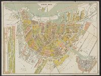
Platte grond van Amsterdam in 1880
Description:
Inzet: [1.] Vondels park ; [2.] Plan van uitbreiding der stad, vastgesteld in 1874., Verso: Gids voor de bezoekers van Amsterdam., and Verso: Lijst van straten, grachten enz.
Publisher:
Funke,
Subject (Geographic):
Amsterdam (Netherlands)--Maps
Found in:
Beinecke Rare Book and Manuscript Library > Amsterdam in 1880 / A. Braakensiek, fec.
Creator:
Published / Created:
1700?]
Call Number:
331 1700A
Container / Volume:
BRBL_00078
Image Count:
1
Resource Type:
Maps, Atlases & Globes
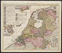
Description:
"Cum privil.", Appears in Schenk's Atlas contractus ... [Amsterdam : Peter Schenk, ca. 1700]., Imperfect: Mutilated, with some loss of text. Sheet measures 53.5 x 62 cm. Verso: "19" (?) in ink ms., Insets: Batavorum colon, and Relief shown pictorially.
Publisher:
Peter Schenk?
Subject (Geographic):
East Indies--Maps--Early works to 1800, Netherlands--Maps--Early works to 1800, and New Netherland--Maps--Early works to 1800
Found in:
Beinecke Rare Book and Manuscript Library > Belgii pars septentrionalis communi nomine vulgo Hollandia : nuncupata continens statum potentissimae Batavorum Reipublicae seu Provincias VII. foederatas. Cum omnium provinciarum insignibus, additis omnibus nominibus urbium et pagorum edente / Petro Sche
Published / Created:
1635
Call Number:
3331 Sc28 1635
Container / Volume:
BRBL_00082
Image Count:
1
Resource Type:
Maps, Atlases & Globes
Description:
Preliminary record.
Subject (Geographic):
North Holland (Netherlands)--Maps--Early works to 1800
Found in:
Beinecke Rare Book and Manuscript Library > Caerte van de Scher-meer...1635...
Published / Created:
1640
Call Number:
3333 Sc26 1640
Container / Volume:
BRBL_00084
Image Count:
1
Resource Type:
Maps, Atlases & Globes
Description:
Preliminary record.
Subject (Geographic):
Scheldt River--Maps--Early works to 1800 and Zeeland (Netherlands : Province)--Maps--Early works to 1800
Found in:
Beinecke Rare Book and Manuscript Library > Caerte vant Scheldt ende Santvliet ... / door Claes Ianβ Visscher.
Creator:
Published / Created:
1743
Call Number:
1975 Folio 31
Collection Title:
[Atlas factice of 42 maps, produced by the Homann Erben firm]
Image Count:
1
Alternative Title:
Staat von der Republic Genova, nach seiner Eintheilung in die ost- u. west-Revier
Publisher:
Homann Erben
Subject (Geographic):
Genoa (Italy) --Maps --Early works to 1800
Subject (Topic):
Atlases, German --Early works to 1800
Collection Created:
[Nuremberg,
Found in:
Beinecke Rare Book and Manuscript Library > Carta Geographica, la quale rappresenta lo Stato della Republica di Genova partita nella Riviera di Levante et di Ponente / [cartographic material] / data in publico per gli Heredi d'Homann ; con privil. imp le 1743 = Staat von der Republic Genova, nach s
Branch:v1.61.6 ,Deployed:2024-06-12T09:55:19-04:00