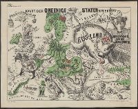
Caricature map., Ill. of people and animals represent international relations., In top margin: Voorwaarts., and Includes text.
Publisher:
W.L. Stoeller,
Subject (Geographic):
Europe--Maps
Subject (Topic):
Franco-Prussian War, 1870-1871--Caricatures and cartoons, Franco-Prussian War, 1870-1871--Maps, and International relations--History--19th century--Maps
Hadol, Paul, 1835-1875. Carte drôlatique d'Europe pour 1870
Published / Created:
[1870]
Call Number:
30 1870D
Container / Volume:
BRBL_00032
Image Count:
1
Resource Type:
Maps, Atlases & Globes
Description:
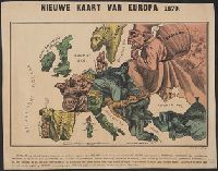
Caricature map., Includes text., National political attitudes are represented by caricatures., and Similar to P. Hudol's Carte drôlatique d'Europe pour 1870.
Publisher:
Emrik & Binger,
Subject (Geographic):
Europe--Maps and Europe--Politics and government--Maps