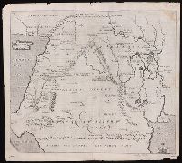
"Arabia the happie, the north part" at lower edge., From Sir Walter Raleigh's History of the world (1614)., In upper left corner: 64; in upper right corner: 65., Relief shown pictorially., Shows a portion of the Mediterranean Sea with Cyprus and Cappadocia to the northwest, the Red Sea and the Persian Sea to the south. Arabia desert and Mesopotamia near center., The map identifies the Home of Abraham at Vrocha (Chaldea), the first plantation of Chus, Babylon, Jerusalem the Garden of Eden, the City of Petra (then known to European only in legend), and the route taken by Abraham into Egypt., and Watermark.
Publisher:
[Printed by William Stansby for Walter Burre],
Subject (Geographic):
Iraq--Historical geography--Maps. and Middle East--Maps--Early works to 1800.
Subject (Name):
Raleigh, Walter, Sir, 1552?-1618. History of the world
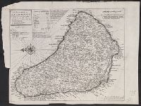
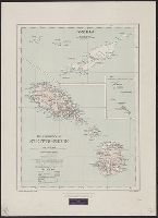
Cross Collection no. 307., From Herman Moll's Atlas minor. ... London : Thomas Bowles and John Bowles, [1736]., Includes table of are, Relief shown pictorially., and Shows churches, forts, plantations, windmills, submerged rocks, etc.
Publisher:
Printed and sold by Tho. Bowles, next ye Chapter House in St. Pauls Church yard & I. Bowles at the Black Horse in Cornhill,
Subject (Geographic):
Barbados--Maps--Early works to 1800
Subject (Name):
Bowles, John, 1701-1779, printer, Bowles, Thomas, -1767, printer, and Moll, Herman, -1732. Atlas minor
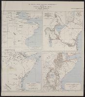
Maps of Eastern Equatorial Africa showing the progress of exploration
Description:
"Eastern Equatorial Africa, Garstin. The Geographical Journal, 1909"--in upper right hand corner. and Eastern Equatorial Africa according to Ptolemy, A.D. 150 -- Eastern Equatorial Africa immediately before Speke's first journey ... 1856 -- Map showing the results of Burton, Speke, and Grant's explorations ... 1863 -- Eastern Equatorial Africa, 1909.
Publisher:
Royal Geographical Society,
Subject (Geographic):
Africa, East--Discovery and exploration--Maps
Subject (Name):
Royal Geographical Society (Great Britain) and Speke, John Hanning,--1827-1864--Travel--Maps
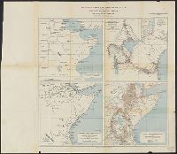
Maps of Eastern Equatorial Africa showing the progress of exploration
Description:
"Eastern Equatorial Africa, Garstin. The Geographical Journal, 1909"--in upper right hand corner. and Eastern Equatorial Africa according to Ptolemy, A.D. 150 -- Eastern Equatorial Africa immediately before Speke's first journey ... 1856 -- Map showing the re
Publisher:
Royal Geographical Society,
Subject (Geographic):
Africa, East--Discovery and exploration--Maps
Subject (Name):
Royal Geographical Society (Great Britain) and Speke, John Hanning,--1827-1864--Travel--Maps
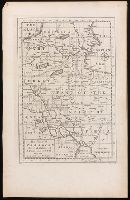
From Thomas Stackhouse's New history of the Holy Bible (London, 1752)., In lower left corner, "Pl. 3"; in lower right corner, "page 24.", Prime meridian: Ferro., Relief shown pictorially., and Watermark.
Publisher:
[Printed for John Hinton],
Subject (Geographic):
Middle East--Historical geography--Maps--Early works to 1800. and Middle East--Maps--Early works to 1800.
Subject (Name):
Hinton, John, -1781 and Stackhouse, Thomas, approximately 1680-1752. New history of the Holy Bible.