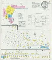
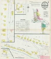
Sanborn fire insurance maps are a rich source of historic data on the urban built environment of North America during the 19th and early 20th centuries. The atlases were created for the purpose of underwriting fire insurance policies, which depended upon accurate and frequently-updated information about construction materials, municipal and transportation infrastructure, industrial and commercial landuse and more. The Yale University Library Map Department scanned its holdings of Sanborn fire insurance maps (consisting primarily of Connecticut towns) in order to make the maps more accessible.
Alternative Title:
June 1927, Moosup, Conn.
Description:
"(3221). (5 sheets).", "Including Almyville.", Contains information on population, prevailing winds, water facilities and fire department., Includes index of streets and specials., Partial cadastral map., Sheets 2-3 at scale 1:600 ; sheets 1, and 4-5 at scale 1:1,200., and SMLMAPL 766 M78 1927: Sheets disbound. Library of Congress copyright stamp on title sheet.
Subject (Geographic):
Moosup (Conn.)--Maps
Subject (Name):
Library of Congress Stamp
Subject (Topic):
Fire risk assessment--Connecticut--Moosup--Maps and Real property--Connecticut--Moosup--Maps
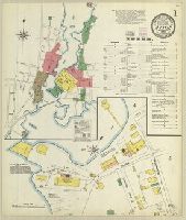
Sanborn fire insurance maps are a rich source of historic data on the urban built environment of North America during the 19th and early 20th centuries. The atlases were created for the purpose of underwriting fire insurance policies, which depended upon accurate and frequently-updated information about construction materials, municipal and transportation infrastructure, industrial and commercial landuse and more. The Yale University Library Map Department scanned its holdings of Sanborn fire insurance maps (consisting primarily of Connecticut towns) in order to make the maps more accessible.
Alternative Title:
Oct. 1903, Mystic, Conn.
Description:
"8 sheets. (6522).", Contains information on population, prevailing winds, water facilities and fire department., Includes index of streets and specials., Partial cadastral map., and SMLMAPL 766 M992 1903: Sheets disbound. "Triplicate" stamp on all sheets. Library of Congress copyright and Map Division stamps on title sheet.
Subject (Geographic):
Mystic (Conn.)--Maps
Subject (Name):
Library of Congress Stamp and Library of Congress. Map Division Stamp
Subject (Topic):
Fire risk assessment--Connecticut--Mystic--Maps and Real property--Connecticut--Mystic--Maps
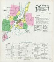
Sanborn fire insurance maps are a rich source of historic data on the urban built environment of North America during the 19th and early 20th centuries. The atlases were created for the purpose of underwriting fire insurance policies, which depended upon accurate and frequently-updated information about construction materials, municipal and transportation infrastructure, industrial and commercial landuse and more. The Yale University Library Map Department scanned its holdings of Sanborn fire insurance maps (consisting primarily of Connecticut towns) in order to make the maps more accessible.
Alternative Title:
May 1924, Mystic, Conn.
Description:
"(1584). (16 sheets).", Contains information on population, prevailing winds, water facilities and fire department., Includes index of streets and specials., Partial cadastral map., Sheets 2-4, 6, 8-14, and 16 at scale 1:600 ; sheets 5, 7, and 15 at scale 1:1,200., and SMLMAPL 766 M992 1924: Sheets disbound. Library of Congress copyright stamp on title sheet.
Subject (Geographic):
Mystic (Conn.)--Maps
Subject (Name):
Library of Congress Stamp
Subject (Topic):
Fire risk assessment--Connecticut--Mystic--Maps and Real property--Connecticut--Mystic--Maps
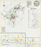
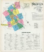
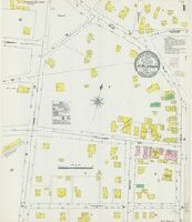
Sanborn fire insurance maps are a rich source of historic data on the urban built environment of North America during the 19th and early 20th centuries. The atlases were created for the purpose of underwriting fire insurance policies, which depended upon accurate and frequently-updated information about construction materials, municipal and transportation infrastructure, industrial and commercial landuse and more. The Yale University Library Map Department scanned its holdings of Sanborn fire insurance maps (consisting primarily of Connecticut towns) in order to make the maps more accessible.
Alternative Title:
Feb. 1904, Naugatuck, Conn.
Description:
"8 sheets. #6319.", Contains information on population, prevailing winds, water facilities and fire department., Includes index of streets and specials., Partial cadastral map., and SMLMAPL 766 N22 1904: Sheets disbound. "Triplicate" stamp on all sheets. Library of Congress copyright and Map Division stamps on title sheet.
Subject (Geographic):
Naugatuck (Conn.)--Maps
Subject (Name):
Library of Congress Stamp and Library of Congress. Map Division Stamp
Subject (Topic):
Fire risk assessment--Connecticut--Naugatuck--Maps and Real property--Connecticut--Naugatuck--Maps
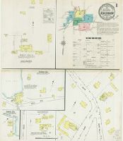
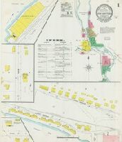
Sanborn fire insurance maps are a rich source of historic data on the urban built environment of North America during the 19th and early 20th centuries. The atlases were created for the purpose of underwriting fire insurance policies, which depended upon accurate and frequently-updated information about construction materials, municipal and transportation infrastructure, industrial and commercial landuse and more. The Yale University Library Map Department scanned its holdings of Sanborn fire insurance maps (consisting primarily of Connecticut towns) in order to make the maps more accessible.
Alternative Title:
Mar. 1923, Naugatuck, Conn.
Description:
" 23 sheets. (5864).", Contains information on population, prevailing winds, water facilities and fire department., Includes index of streets and specials., Partial cadastral map., Sheets 1-9 at scale 1:600 ; sheets 10-23 at scale 1:1,200., and SMLMAPL 766 N22 1923: Sheets disbound. Library of Congress copyright stamp on title sheet.
Subject (Geographic):
Naugatuck (Conn.)--Maps
Subject (Name):
Library of Congress Stamp
Subject (Topic):
Fire risk assessment--Connecticut--Naugatuck--Maps and Real property--Connecticut--Naugatuck--Maps
Sanborn fire insurance maps are a rich source of historic data on the urban built environment of North America during the 19th and early 20th centuries. The atlases were created for the purpose of underwriting fire insurance policies, which depended upon accurate and frequently-updated information about construction materials, municipal and transportation infrastructure, industrial and commercial landuse and more. The Yale University Library Map Department scanned its holdings of Sanborn fire insurance maps (consisting primarily of Connecticut towns) in order to make the maps more accessible.
Alternative Title:
May 1906, New Canaan, Conn.
Description:
"3 sheets. 8777.", Contains information on population, prevailing winds, water facilities and fire department., Partial cadastral map., and SMLMAPL 766 N423 1906: Sheets disbound. "Triplicate" stamp on all sheets. Library of Congress copyright and Map Division stamps on title sheet.
Subject (Geographic):
New Canaan (Conn.)--Maps
Subject (Name):
Library of Congress Stamp and Library of Congress. Map Division Stamp
Subject (Topic):
Fire risk assessment--Connecticut--New Canaan--Maps and Real property--Connecticut--New Canaan--Maps
Sanborn fire insurance maps are a rich source of historic data on the urban built environment of North America during the 19th and early 20th centuries. The atlases were created for the purpose of underwriting fire insurance policies, which depended upon accurate and frequently-updated information about construction materials, municipal and transportation infrastructure, industrial and commercial landuse and more. The Yale University Library Map Department scanned its holdings of Sanborn fire insurance maps (consisting primarily of Connecticut towns) in order to make the maps more accessible.
Alternative Title:
Mar. 1912, New Canaan, Conn.
Description:
"4680. (6 sheets).", Contains information on population, prevailing winds, water facilities and fire department., Includes index of streets and specials., Partial cadastral map., and SMLMAPL 766 N423 1912: Sheets disbound. "Triplicate" stamp and Library of Congress copyright stamps on title sheet.
Subject (Geographic):
New Canaan (Conn.)--Maps
Subject (Name):
Library of Congress Stamp
Subject (Topic):
Fire risk assessment--Connecticut--New Canaan--Maps and Real property--Connecticut--New Canaan--Maps
Sanborn fire insurance maps are a rich source of historic data on the urban built environment of North America during the 19th and early 20th centuries. The atlases were created for the purpose of underwriting fire insurance policies, which depended upon accurate and frequently-updated information about construction materials, municipal and transportation infrastructure, industrial and commercial landuse and more. The Yale University Library Map Department scanned its holdings of Sanborn fire insurance maps (consisting primarily of Connecticut towns) in order to make the maps more accessible.
Alternative Title:
Jan. 1927, New Canaan, Conn.
Description:
"(2941). (8 sheets).", "Including Talmadge Hill.", Contains information on population, prevailing winds, water facilities and fire department., Includes index of streets and specials., Partial cadastral map., Sheets 2-6 at scale 1:600 ; sheets 1 and 7-8 at scale 1:1,200., and SMLMAPL 766 N423 1927: Sheets disbound. Library of Congress copyright stamp on title sheet.
Subject (Geographic):
New Canaan (Conn.)--Maps
Subject (Name):
Library of Congress Stamp
Subject (Topic):
Fire risk assessment--Connecticut--New Canaan--Maps and Real property--Connecticut--New Canaan--Maps
Sanborn fire insurance maps are a rich source of historic data on the urban built environment of North America during the 19th and early 20th centuries. The atlases were created for the purpose of underwriting fire insurance policies, which depended upon accurate and frequently-updated information about construction materials, municipal and transportation infrastructure, industrial and commercial landuse and more. The Yale University Library Map Department scanned its holdings of Sanborn fire insurance maps (consisting primarily of Connecticut towns) in order to make the maps more accessible.
Alternative Title:
Dec. 1903, New Hartford, Conn.
Description:
"& Pine Meadows.", "6644. 6 sheets.", Contains information on population, prevailing winds, water facilities and fire department., Includes index of streets and specials., Partial cadastral map., and SMLMAPL 766 N455 1903: Sheets disbound. "Triplicate" stamp on all sheets. Library of Congress copyright and Map Division stamps on title sheet.
Subject (Geographic):
New Hartford (Conn. : Town)--Maps
Subject (Name):
Library of Congress Stamp and Library of Congress. Map Division Stamp
Subject (Topic):
Fire risk assessment--Connecticut--New Hartford (Town)--Maps and Real property--Connecticut--New Hartford (Town)--Maps
Sanborn fire insurance maps are a rich source of historic data on the urban built environment of North America during the 19th and early 20th centuries. The atlases were created for the purpose of underwriting fire insurance policies, which depended upon accurate and frequently-updated information about construction materials, municipal and transportation infrastructure, industrial and commercial landuse and more. The Yale University Library Map Department scanned its holdings of Sanborn fire insurance maps (consisting primarily of Connecticut towns) in order to make the maps more accessible.
Alternative Title:
June 1912, New Hartford, Conn.
Description:
"5008. 6 sheets.", "Including Pine Meadow.", Contains information on population, prevailing winds, water facilities and fire department., Includes index of streets and specials., Partial cadastral map., and SMLMAPL 766 N455 1912: Sheets disbound. Library of Congress copyright stamp on title sheet.
Subject (Geographic):
New Hartford (Conn. : Town)--Maps
Subject (Name):
Library of Congress Stamp
Subject (Topic):
Fire risk assessment--Connecticut--New Hartford (Town)--Maps and Real property--Connecticut--New Hartford (Town)--Maps