Mercator, Gerhard, 1512-1594 Ptolemy, active 2nd century
Published / Created:
1578
Call Number:
3546 1578
Container / Volume:
BRBL_00113
Image Count:
2
Resource Type:
Maps, Atlases & Globes
Alternative Title:
Tabulae geographicae.
Description:
From Tabulae geographicae Cl: Ptolemei ad mentem autoris restitutae & emendate per Gerardum Mercatorem ..., Latin text on verso., and Sheet measures 41.5 x 53 cm.
Publisher:
Typis Godefridi Kempensis, Anno Virgineit partus,
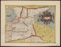
Subject (Geographic):
Armenia--Maps--Early works to 1800 and Asia--Maps--Early works to 1800
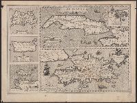
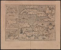
Ancillary maps: Insula Iamaica -- Ins. S. Ioannis -- Is. Margareta cum confinijis., Cuba Insula includes inset "Havana portus celeberimus totius indiae Occidentalis.", Latin text on verso; with caption title "Cuba, Hispaniola Iamai, and Relief shown pictorially.
Publisher:
Jodocus Hondius,
Subject (Geographic):
Cuba--Maps--Early works to 1800 and Hispaniola--Maps--Early works to 1800
Subject (Name):
Hondius, Jodocus, 1563-1612 and Mercator, Gerhard, 1512-1594. Atlas. French
Cuba Insula includes inset "Havana portus celeberimus totius indiae Occidentalis.", French text on verso; with caption title "Les isles de la Cuba, Espaignole, Iamaique, de S. Iean et Margarite," paginated 701, 704, with signatures 8P., and Relief shown pictorially.
Publisher:
Hendrik Hondius,
Subject (Geographic):
Cuba--Maps--Early works to 1800 and Hispaniola--Maps--Early works to 1800
Subject (Name):
Hondius, Hendrik, 1597-1651 and Mercator, Gerhard, 1512-1594. Atlas. French
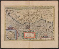
Mercator, Gerhard, 1512-1594 Mercator, Rumold, ca. 1545-1599
Published / Created:
[ca. 1595]
Call Number:
30 1595
Container / Volume:
BRBL_00029
Image Count:
2
Resource Type:
Maps, Atlases & Globes
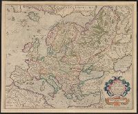
Alternative Title:
Evropa
Description:
From: Atlas sive cosmogravicæ meditationes de fabrica mundi et fabricati figura / Gerardo Mercatore Rupelmundano ... autore. Atlantis pars altera: Geographia nova totius mundi (Duisburgi Clivorum : [s.n.] ; Dusseldorpii : excudebat Albertus Busius ..., su
From the author's Gerardi Mercatoris atlas. 1628., Inset: I. S. Thomae., Map text in Latin. Text on verso in French., Relief shown pictorially., and Text on verso titled "Guinee, avec les isles de S. Thomas, du Prince, et d'Anobon," p. 637 and 640.
Publisher:
Sumptibus & typis aeneis Henrici Hondij,
Subject (Geographic):
Africa, West--Maps--Early works to 1800
Subject (Name):
Hondius, Hendrik, 1597-1651 and Mercator, Gerhard, 1512-1594. Gerardi Mercatoris Atlas
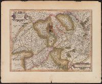
Appears in Mercator's Galliae tabula geographicae ... [Duisburg ca.1595]., Latin text on verso., page number on verso "161-162"., Relief shown pictorially., and Sheet measures 45.5 x 56.2 cm.
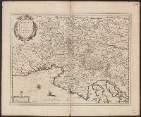
Bar scale given in "milliaria Italica communia"., From Blaeu's Theatrum orbis terrarum, 1635., In Latin on verso; with caption title "Descriptio Karstiae, Carniolae, Windorum marchiae, comitatus Ciliae fori Iulii, necnon Istriae" and signature K., and Relief sho
Publisher:
Guiljelm. Blaeu excudit,
Subject (Geographic):
Carniola (Slovenia)--Maps--Early works to 1800 and Croatia--Maps--Early works to 1800
Subject (Name):
Blaeu, Joan, 1596-1673. Theatrum orbis terrarum and Blaeu, Willem Janszoon, 1571-1638. Theatrum orbis terrarum
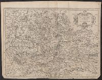
Bar scale given in "miliaria Germanica communia"., From Henricus Hondius and Joannes Janssonius's Atlas (English ed.), 1636., Imperfect: trimmed, with, In English on verso; with caption title "The description of the Bishoprick of S, and Relief shown pictorially.
Publisher:
Sumptibus Henrici Hondij,
Subject (Geographic):
Salzburg (Austria : Land)--Maps--Early works to 1800
Subject (Name):
Hondius, Hendrik, 1597-1651. Atlas novus. English and Jansson, Jan, 1588-1664. Atlas novus. English