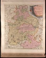
Backed with paper. Ms. no. "27" in upper right-hand corner. Sheet measures 52.7 x 53.7 cm. No. 27 of 87 maps bound together., Bar scales given in "milliaria Germanica" and "mill. Gallica"., Prime meridian: Ferro., and Relief shown pictorially.
Publisher:
Peter Schenk,
Subject (Geographic):
Austria--Maps--Early works to 1800. and Bavaria (Germany)--Maps--Early works to 1800.
Minimal level cataloging record. and Relief shown pictorially.
Publisher:
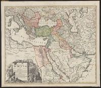
Homann,
Subject (Geographic):
Middle East--Maps--Early works to 1800, Turkey--Administrative and political divisions--Maps--Early works to 1800, and Turkey--Maps--Early works to 1800
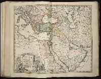
Tabula ex novissimus ad mentem de L'Islii, inprimis vero celeberrimi geographi Dni. I.M. Hasii, Prof. Vitemb. delineata a. 1737
Description:
"Cum privil. S.C.M. Grat.", Bar scales given in "milliaria Germanica," "milliaria Turcica," and "mill. Italica.", Relief shown pictorially., and Variant: without privilege statement in cartouche. Sheet measures 52.5 x 60.4 cm.
Publisher:
[Homann Erben,
Subject (Geographic):
Balkan Peninsula--Maps--Early works to 1800, Egypt--Maps--Early works to 1800, Libya--Maps--Early works to 1800, and Middle East--Maps--Early works to 1800
Subject (Name):
Hase, Johann Matthias, 1684-1742 and Homann Erben (Firm)
Hase, Johann Matthias, 1684-1742 Homann Erben (Firm) Homann, Johann Baptist, 1663-1724
Published / Created:
[1737]
Call Number:
1983 Folio 23
Collection Title:
[Atlas factice of 50 maps, primarily by Johann Baptist Homann and/or issued by the Homann Erben
Image Count:
1
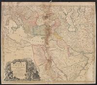
Alternative Title:
Tabula ex novissimus ad mentem de L'Islii, inprimis vero celeberrimi geographi Dni. I.M. Hasii, Prof. Vitemb. delineata a. 1737
Description:
Number 13 of 50 works bound together.
Publisher:
[Homann Erben]
Subject (Geographic):
Balkan Peninsula --Maps --Early works to 1800, Egypt --Maps --Early works to 1800, Libya --Maps --Early works to 1800, and Middle east --Maps --Early works to 1800