Charte worauf in einem Begriff und Anblick alle natürliche politische und Kunst-termini oder Wörter benen̄et.
Description:
1an, Demonstrates cartographic terms, symbols, depictions of landforms, etc., Has watermark., Relief shown pictorially., and Title in upper margin: Charte worauf in einem Begriff und Anblick alle natürliche politische und Kunst-termini oder Wörter benen̄et ...
Publisher:
Matthaeo Seutter,
Subject (Topic):
Cartography--Germany, Cartography--Methodology--Maps, Imaginary places--Maps--Early works to 1800, Maps--Symbols, and Maps--Terminology
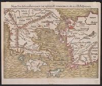
Noua Graecia, secundum omnes eius regiones & prouincias citra & ultra Hellespontum, Noua Graecia, secundum omnes eius regiones et prouincias citra et ultra Hellespontum, and Nova Graecia, secundum omnes eius regiones & provincias citra & ultra Hellespontum
Description:
Appears in the author's Cosmographiae uniuersalis. 1550., Hand col. Sheet measures 31 x 37 cm. Lanman Collection., Latin and German., and Relief shown pictorially.
Publisher:
s.n.,
Subject (Geographic):
Aegean Islands (Greece and Turkey)--Maps--Early works to 1800, Greece--Maps--Early works to 1800, and Turkey--Maps--Early works to 1800
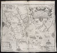
From Blaeu's Novus atlas ... Amsterdami : Apud Guiljelmum Blaeuw, 1635., Oriented west., Relief shown pictorially., Upper left: Portait of Powhatan with subtitle: Status regis Powhatan quando prefectus Smith Captivus illi daretur., Upper right: Key to symbols., and Verso in German, with running title "Landschafft Virginia" and signature "B".
Publisher:
Ex Officina Guiljelmi Blaeuw,
Subject (Geographic):
Virginia--Maps--Early works to 1800
Subject (Name):
Blaeu, Willem Janszoon, 1571-1638. Theatrum orbis terrarum. German, Gryp, Dirck, engraver, Powhatan, ca. 1550-1618, and Smith, John, 1580-1631
Subject (Topic):
Powhatan Indians--Pictorial works--Early works to 1800
Abbildung der neuen russischen Haupt-Residenz und See Statt St. Petersburg., Neue Abbildung von der Situation der Statt St. Petersburg., and Neue u: accurate Abbildung der von dem grossen russ. Kaiser Petro Alexiewiz ao. 1703 an dem Aussfl. dess Neva Stroms erb
Description:
Abbildung der neuen russischen Haupt-Residenz und See Statt St. Petersburg -- Neue Abbildung von der Situation der Statt St. Petersburg., Includes text, index to selected buildings, and decorative cartouches., Latin and German., and Relief shown pictorially.
Publisher:
M. Seutter,
Subject (Geographic):
Neva River Watershed (Russia)--Maps--Early works to 1800, Saint Petersburg (Russia)--Maps--Early works to 1800, and Saint Petersburg Region (Russia)--Maps--Early works to 1800
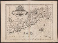
Appears in 1634 and 1635 German eds. of Blaeu's Novus atlas., Bar scales in "Miliaria Germanica communia" and "Miliaria Gallica communia.", Cross Collection no. 354., In German on verso, with caption titles "Königreich Peru" and signature L., Ms. nos. on recto and verso: 349; 348., Oriented with north to the left., and Relief shown pictorially.
Publisher:
Guiljelmus Blaeuw excudit,
Subject (Geographic):
Peru--Maps--Early works to 1800
Subject (Name):
Blaeu, Willem Janszoon, 1571-1638. Theatrum orbis terrarum. German
Hase, Johann Matthias, 1684-1742 Homann Erben (Firm) Lowitz, G. M. (George Moritz), 1722-1774
Published / Created:
1746
Call Number:
1973 Folio 30
Collection Title:
[Atlas factice of 32 maps and 1 distance table, produced by the Homann Erben firm]
Image Count:
1
Alternative Title:
Mappe-monde qui represente les deux hemispheres savoir celui de l’orient et celui de l’occident, tiree des quatre cartes generales de feu M. le profess. Hasius, dressee par Mr. G.M. Lowitz et publiee par les Heritiers de Homann and Planiglobii terrestris mappa vniversalis
Description:
Map colored to show distribution of religions.
Publisher:
[Homann Erben]
Subject (Topic):
Atlases, German --Early works to 1800, Religion --Maps --Early works to 1800, and World maps --Early works to 1800
Mappe-monde qui représente les deux hemisphères savoir celui de l'orient et celui de l'occident, tirée des quatre cartes générales de feu M. le profess. Hasius, Planiglobii terrestris mappa vniversalis, and Schul-Atlas von zwantzig General- und Special-Lan
Description:
Appears in Homann heirs' Schul-atlas von zwantzig general-und special-land karten ... Cf. Phillips, no. 293., Imperfect: torn along fold, with no loss of text. Shee, Map colored to show distribution of religions., and Title in Latin and French; legend in German.
Publisher:
Homann Erben],
Subject (Name):
Hase, Johann Matthias, 1684-1742 and Homann Erben (Firm)
Subject (Topic):
Religion--Maps--Early works to 1800 and World maps--Early works to 1800