Skip to search
Skip to main content
Skip to first result
Search
You Searched For
Extent of Digitization
Completely digitized
Publication Place
Paris :
New Search
Search Results
Creator:
Published / Created:
[175-?]
Call Number:
7325 L93 1755
Container / Volume:
BRBL_00377
Image Count:
1
Resource Type:
Maps, Atlases & Globes
Alternative Title:
Veue de Louisbourg.
Description:
Includes "Veue de Louisbourg." and Relief shown by hachures. Depths shown by soundings.
Publisher:
Chez le Sr. le Rouge, Rue des gr. ds. Augustins,
Subject (Geographic):
Louisbourg (N.S.)--Maps--Early works to 1800
Subject (Topic):
Nautical charts--Nova Scotia--Louisbourg--Maps--Early works to 1800
Found in:
Beinecke Rare Book and Manuscript Library > Port de Louisbourg / leve ́par le Cher. de la Rigaudiere, Lieutnt. de Vaisseaux du Roy.
Creator:
Published / Created:
[1868?]
Call Number:
682H 1868
Container / Volume:
BRBL_00350
Image Count:
1
Resource Type:
Maps, Atlases & Globes
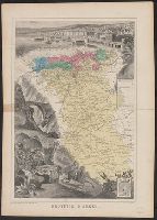
Description:
Inset of "Armes d'Alger" in lower right corner., Map of Algeria centered among pictorial representation of the town of Alger and a, and Shows civil and military regions noted by colors, agricultural colonies, regional boundaries, and elements of infrastructure.
Publisher:
Migeon,
Subject (Geographic):
Algeria--Maps
Found in:
Beinecke Rare Book and Manuscript Library > Province d'Alger / Dressé par A. Vuillemin.
Creator:
Published / Created:
[1868?]
Call Number:
682H 1868
Container / Volume:
BRBL_00350
Image Count:
1
Resource Type:
Maps, Atlases & Globes
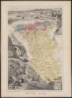
Description:
"Imp.e Migeon, Editeur, 11 rue du Moulin Vert, Paris.", Inset of "Armes d'Alger" in lower right corner., Map o, Scale in kilometres., and Shows civil and military regions noted by colors, agricultural colonies, regional boundaries, and elements of infrastructure.
Publisher:
Migeon,
Subject (Geographic):
Algeria--Maps
Found in:
Beinecke Rare Book and Manuscript Library > Province d'Alger / Dressé par A. Vuillemin.
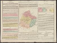
Published / Created:
[1826?]
Call Number:
3818 1826
Container / Volume:
BRBL_00174
Image Count:
1
Resource Type:
Maps, Atlases & Globes
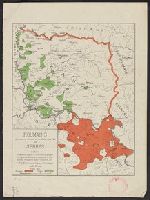
Description:
Statistics on margins of map.
Publisher:
Baudouin Frères,
Subject (Geographic):
Sarthe (France)--Maps
Found in:
Beinecke Rare Book and Manuscript Library > Sarthe.
Branch:v1.62.0 ,Deployed:2024-06-26T09:57:10-04:00