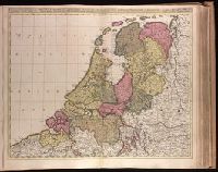
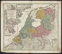
Appears in Valk and Schenk's Atlantis sylloge compendiosa, ca. 1702., Backed with paper. Ms. no. "40" in upper-right corner. Sheet measures 53.6 x 63.0 cm. No. 39 of 87 maps bound together., Bar scales given in "horae itinerissive milliaria Gallica" and "milliaria Germanica"., Prime meridian: Ferro., and Watermark.
Publisher:
Gerard Valk,
Subject (Geographic):
Netherlands--Maps--Early works to 1800.
Subject (Name):
Schenk, Peter, 1660-1718 or 1719. Atlantis sylloge compendiosa., Valck, G. (Gerard), 1651 or 1652-1726. Atlantis sylloge compendiosa., and Valck, Leonard, 1675-1746.
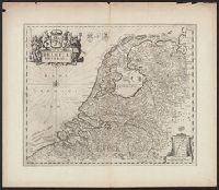
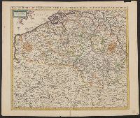
"Cum privil.", Appears in Schenk's Atlas contractus ... [Amsterdam : Peter Schenk, ca. 1700]., Imperfect: Mutilated, with some loss of text. Sheet measures 53.5 x 62 cm. Verso: "19" (?) in ink ms., Insets: Batavorum colon, and Relief shown pictorially.
Publisher:
Peter Schenk?
Subject (Geographic):
East Indies--Maps--Early works to 1800, Netherlands--Maps--Early works to 1800, and New Netherland--Maps--Early works to 1800
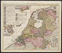
Imperfect: Split into 2 pieces. Mounted on board. Sheet measures 51.3 x 59.7 cm. and Three insets: 1) at top. Batavorum coloniae occidental indiis septentrionalis Americae implantatae. With view of New Amsterdam. 2) at left. India orientalis Batavoru
Publisher:
[Johann Baptist Homann,
Subject (Geographic):
Netherlands--Maps--Early works to 1800 and New York (State)--Maps
Sheet measures 53.4 x 61.4 cm. Ms. note on verso: No. 9, Holland. and Three insets: 1) at top. Batavorum coloniae occidental indiis septentrionalis Americae implantatae. With view of New Amsterdam. 2) at left. India orientalis Batavorum commerciis,
Publisher:
[Johann Baptist Homann,
Subject (Geographic):
Netherlands--Maps--Early works to 1800 and New York (State)--Maps
Homann Erben (Firm) Mayer, Tobias, 1723-1762 Schneider, R. A.
Published / Created:
1747 [i.e. 1748?]
Call Number:
1975 Folio 31
Collection Title:
[Atlas factice of 42 maps, produced by the Homann Erben firm]
Image Count:
1
Alternative Title:
Carte des XVII. provinces ou de l’Allemagne inferievre, dressee suivant la projection stereographique, et appueyee par les mesures faites de Mess. Cassini, Snellius et Mouschenbrok, par Mr. Tob. Majer de la Societe geographique, et publiee par les Heritiers de Homann, l’An 1748
Publisher:
Cura et Studio Homannianorum Heredum
Subject (Geographic):
Belgium --Maps --Early works to 1800, Benelux countries --Maps --Early works to 1800, Luxembourg --Maps --Early works to 1800, and Netherlands --Maps --Early works to 1800
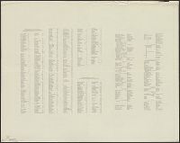
[Atlas factice of 32 maps and 1 distance table, produced by the Homann Erben firm]
Image Count:
2
Alternative Title:
Carte des XVII. provinces ou de l’Allemagne inferievre, dressee suivant la projection stereographique, et appueyee par les mesures faites de Mess. Cassini, Snellius et Mouschenbrok, par Mr. Tob. Majer de la Societe geographique, et publiee par les Heritiers de Homann, l’An 1748
Publisher:
Cura et Studio Homannianorum Heredum
Subject (Geographic):
Belgium --Maps --Early works to 1800, Benelux countries --Maps --Early works to 1800, Luxembourg --Maps --Early works to 1800, and Netherlands --Maps --Early works to 1800