Skip to search
Skip to main content
Skip to first result
Search
You Searched For
Format
cartographic
New Search
Search Results
Creator:
Published / Created:
1866]
Call Number:
814 V59 1866
Container / Volume:
BRBL_00558
Image Count:
1
Resource Type:
Maps, Atlases & Globes
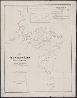
Description:
Includes statement of approval by Henry H. Eames, state geologist of Minn., and note on lake dimensions. and Inset: Enlarged plan of Grande Isle.
Publisher:
s.n.,
Subject (Geographic):
Vermilion Lake (Minn.)--Maps
Subject (Name):
Eames, Henry H and Western Engraving Co
Found in:
Beinecke Rare Book and Manuscript Library > Map of Vermilion Lake, St. Louis Co., Minnesota : from official surveys & other sources / compiled and drawn by A.J. Hill, March 1866.
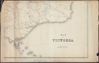
Creator:
Published / Created:
1872
Call Number:
263 1872
Container / Volume:
BRBL_00023
Image Count:
4
Resource Type:
Maps, Atlases & Globes
Publisher:
The Office,
Subject (Geographic):
Victoria--Maps
Found in:
Beinecke Rare Book and Manuscript Library > Map of Victoria / constructed and engraved at the Surveyor General's Office, Melbourne ; G.A. Windsor, draughtsman ; William Slight, engraver.
Published / Created:
1826
Call Number:
783 1826
Container / Volume:
BRBL_00508
Image Count:
1
Resource Type:
Maps, Atlases & Globes
Description:
Drawn by D.H. Vance; engraved by J.H. Young., Hand-colored engraving with statistical tables for the two states and for the District of Colombia. In brown leather-covered forlder., and Inset: Plan of Washington city & Georgetown, 10 x 14 cm.
Publisher:
A. Finley,
Subject (Geographic):
Virginia--Maps
Found in:
Beinecke Rare Book and Manuscript Library > Map of Virginia and Maryland constructed from the best authorities.
Creator:
Published / Created:
[1865?]
Call Number:
837gfc V81 1865
Container / Volume:
BRBL_00595
Image Count:
1
Resource Type:
Maps, Atlases & Globes
Description:
"Entered according to act of Congress in the year 1865 by Higginson & Goldsworthy in the clerks office of the district court of the northern district of the state of California.", Oriented with north toward upper right., and Relief shown by hachures.
Publisher:
A. Gensoul, and Pacific Map Depot :
Subject (Geographic):
Comstock Lode (Nev.)--Maps
Subject (Name):
Gensoul, A. (Adrien), Gray, W. Vallance, Nagel, L. (Louis), and Pacific Map Depot
Subject (Topic):
Mines and mineral resources--Nevada--Maps and Mining districts--Nevada--Maps
Found in:
Beinecke Rare Book and Manuscript Library > Map of Virginia, Gold Hill, Devils Gate, American Flat gold & silver mining districts : state of Nevada / Higginson & Goldsworthy, civil & mining engineers ; W. Vallance Gray, lith.
Published / Created:
1861
Call Number:
783hc 1861B
Container / Volume:
BRBL_00511
Image Count:
1
Resource Type:
Maps, Atlases & Globes
Publisher:
J.T. Paterson,
Subject (Geographic):
Virginia--Maps
Found in:
Beinecke Rare Book and Manuscript Library > Map of Virginia, Maryland &c. seat of war.
Creator:
Published / Created:
1911
Call Number:
846gbc J777 1911
Container / Volume:
BRBL_00623
Image Count:
1
Resource Type:
Maps, Atlases & Globes
Description:
Cadastral map showing land ownership. and Includes text.
Publisher:
Robert A. Welcke, Photo-lith.,
Subject (Geographic):
Josephine County (Or.)--Maps
Subject (Name):
Waldo Consolidated Gold Mining Company
Subject (Topic):
Gold mines and mining--Oregon--Josephine County--Maps and Real property--Oregon--Josephine County--Maps
Found in:
Beinecke Rare Book and Manuscript Library > Map of Waldo Consolidated Gold Mining Co. of Oregon : property in Waldo Mining District, Josephine County , Ore. / by A.H. Gunnell.
Creator:
Published / Created:
1870
Call Number:
847 1870
Container / Volume:
BRBL_00625
Image Count:
4
Resource Type:
Maps, Atlases & Globes
Alternative Title:
Washington Territory
Description:
Relief shown by hachures and spot heights. Depths shown by soundings. and Some copies in publisher's binding with title: Washington Territory.
Publisher:
G.W. & C.B. Colton & Co.,
Subject (Geographic):
Washington (State), Western--Maps
Subject (Name):
G.W. & C.B. Colton & Co
Found in:
Beinecke Rare Book and Manuscript Library > Map of Washington Territory : west of the Cascade Mountains / compiled from the government surveys by Chas. A. White, C.E.
Creator:
Published / Created:
1882]
Call Number:
779 1882
Container / Volume:
BRBL_00505
Image Count:
1
Resource Type:
Maps, Atlases & Globes
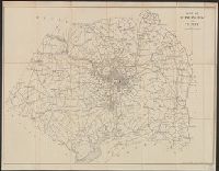
Description:
Road map of area including D.C., Alexandria, Fairfax, Prince Georges, and lower Montgomery counties. and Shows radial distances from the Capitol.
Publisher:
s.n.,
Subject (Geographic):
Washington Metropolitan Area--Road maps and Washington Region--Road maps
Found in:
Beinecke Rare Book and Manuscript Library > Map of Washington and vicinity / prepared at the office of the U.S. Geological Survey, 1882.
Creator:
Published / Created:
1918
Call Number:
737 W31 1914
Container / Volume:
BRBL_00385
Image Count:
1
Resource Type:
Maps, Atlases & Globes
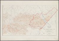
Description:
Shows contours & spot hts., roads & trails, hydrographic detail.
Publisher:
Dept. of the Interior, Canada,
Subject (Geographic):
Waterton Lakes National Park (Alta.)--Maps
Subject (Name):
Bridgland, M. P. (Morrison Parsons), 1878-, Canada. Dept. of the Interior, and Wheeler, A. O. (Arthur Oliver), 1860-1945
Found in:
Beinecke Rare Book and Manuscript Library > Map of Waterton Lakes Park, Alberta [map] / from photographic surveys by M. P. Bridgland, D.L.S. and A. O. Wheeler, B.C.L.S. ; drawn and printed at the Surveyor General's Office.
Creator:
Published / Created:
January 1912.
Call Number:
824 1912
Container / Volume:
BRBL_00570
Image Count:
1
Resource Type:
Maps, Atlases & Globes
Alternative Title:
Outline map of the city of Kearney, Buffalo county, Nebraska
Description:
"Compliments of Kearney Land Company." and Coordinates not present on map and are approximated.
Publisher:
Kearney Land Co.,
Subject (Geographic):
Kearny (Neb.)--Maps
Subject (Name):
Kearney Land Company, publisher
Subject (Topic):
Real property--Nebraska--Kearney--Maps
Found in:
Beinecke Rare Book and Manuscript Library > Map of Watson Ranch tracts near city of Kearney for Kearney Land Company / E.H. Morey, C.E.
Branch:v1.61.6 ,Deployed:2024-06-12T09:55:33-04:00