Skip to search
Skip to main content
Skip to first result
Search
You Searched For
Genre
Maps
New Search
Search Results
Published / Created:
1913
Call Number:
641 1913
Container / Volume:
BRBL_00338
Image Count:
1
Resource Type:
Maps, Atlases & Globes
Alternative Title:
Rhodesia under the administration of the British South Africa Company and South Africa, shewing relative position of Rhodesia.
Description:
Inset: South Africa, shewing relative position of Rhodesia., Relief shown by spot heights., and Shows railways and mines.
Publisher:
Waterlow & Sons,
Subject (Geographic):
Zambia--Maps and Zimbabwe--Maps
Subject (Name):
British South Africa Company
Subject (Topic):
Mines and mineral resources--Zambia--Maps, Mines and mineral resources--Zimbabwe--Maps, Railroads--Zambia--Maps, and Railroads--Zimbabwe--Maps
Found in:
Beinecke Rare Book and Manuscript Library > Map of Rhodesia under the administration of the British South Africa Company.
Published / Created:
1912
Call Number:
641 1912
Container / Volume:
BRBL_00338
Image Count:
1
Resource Type:
Maps, Atlases & Globes
Alternative Title:
Rhodesia under the administration of the British South Africa Company and South Africa, shewing relative position of Rhodesia.
Description:
Inset: South Africa, shewing relative position of Rhodesia., Relief shown by spot heights., and Shows railways and mines.
Publisher:
Waterlow & Sons,
Subject (Geographic):
Zambia--Maps and Zimbabwe--Maps
Subject (Name):
British South Africa Company
Subject (Topic):
Mines and mineral resources--Zambia--Maps, Mines and mineral resources--Zimbabwe--Maps, Railroads--Zambia--Maps, and Railroads--Zimbabwe--Maps
Found in:
Beinecke Rare Book and Manuscript Library > Map of Rhodesia under the administration of the British South Africa Company.
Published / Created:
1896
Call Number:
783 R41 1896
Container / Volume:
BRBL_00510
Image Count:
2
Resource Type:
Maps, Atlases & Globes
Alternative Title:
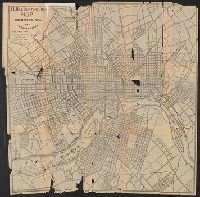
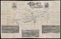
J.L. Hill Printing Co.'s Map of Richmond Virgina and Surroundings.
Description:
Imperfect: mutilated, frayed.
Publisher:
J.L. Hill Printing Co. ,
Subject (Geographic):
Richmond (Virginia)--Maps
Found in:
Beinecke Rare Book and Manuscript Library > Map of Richmond Virgina and Surroundings / Compiled from Redd's survey by Arthur Scrivenor.
Creator:
Published / Created:
[1922]
Call Number:
834 R59 1921
Container / Volume:
BRBL_00589
Image Count:
1
Resource Type:
Maps, Atlases & Globes
Alternative Title:
Union Pacific System map of Rocky Mountain National (Estes) Park, Denver Mountain parks
Description:
"3-8-'22.", "6062.", "Union Pacific System" at head of title., Includes inset showing "Union Pacific System and connections.", and Relief shown by shading and spot heights.
Publisher:
Poole Bros.,
Subject (Geographic):
Rocky Mountain National Park (Colo.)--Maps
Subject (Name):
Poole Brothers and Union Pacific System--Maps
Found in:
Beinecke Rare Book and Manuscript Library > Map of Rocky Mountain National (Estes) Park, Denver Mountain parks / Copyright by Union Pacific System.
Creator:
Published / Created:
1923
Call Number:
737 R59 1923
Container / Volume:
BRBL_00385
Image Count:
1
Resource Type:
Maps, Atlases & Globes
Description:
Includes inset showing location at 1:19,008,000., Relief shown by contours and spot heights., and Shows parts of Banff National Park and Peter Lougheed Provincial Park.
Publisher:
Department of the Interior, Canada,
Subject (Geographic):
Banff National Park (Alta.)--Maps and Peter Lougheed Provincial Park (Alta.)--Maps
Found in:
Beinecke Rare Book and Manuscript Library > Map of Rocky Mountains Park / compiled, drawn and printed by the Topographical Survey of Canada.
Creator:
Published / Created:
[1888?]
Call Number:
796 1888
Container / Volume:
BRBL_00526
Image Count:
1
Resource Type:
Maps, Atlases & Globes
Description:
Includes text., Latest date mentioned in text "July 3rd 1888.", and Soundings in feet.
Publisher:
Dallas Lith. Co.,
Subject (Geographic):
Sabine Bank--Maps, Sabine Pass (Tex.)--Maps, and Sabine-Neches Estuary (La. and Tex.)--Maps
Subject (Name):
Dallas Lith. Co
Found in:
Beinecke Rare Book and Manuscript Library > Map of Sabine Pass : showing the lake and its tributaries, the harbor, the city and railway connection, the bar and jetty walls, as well as Sabine Bank in the Gulf of Mexico / [compiled by] L.J. Kopke, civil engineer, Beaumont, Texas.
Creator:
Published / Created:
1906?]
Call Number:
795gfa Sa13 1905
Container / Volume:
BRBL_00523
Image Count:
1
Resource Type:
Maps, Atlases & Globes
Alternative Title:
Professional paper (Geological Survey (U.S.)) ; no. 46. and U.S. Geological Survey. Professional paper ; no. 46, Pl. XLI
Description:
"Surveyed in 1902-3.", Below scale: 1905., and Relief shown by contours, spot heights, and gradient tints.
Publisher:
U.S. G.P.O.,
Subject (Name):
Julius Bien & Co and Veatch, A. C. (Arthur Clifford), 1878-1938. Geology and underground water resources of northern Louisiana and southern Arkansas
Subject (Topic):
Groundwater--Arkansas--Maps and Groundwater--Louisiana--Maps
Found in:
Beinecke Rare Book and Manuscript Library > Map of Sabine artesian reservoir in northern Louisiana and southern Arkansas / by A.C. Veatch.
Creator:
Published / Created:
1949
Call Number:
844 Sa14 1949
Container / Volume:
BRBL_00608
Image Count:
2
Resource Type:
Maps, Atlases & Globes
Description:
Also shows area surrounding Sacramento. and Indexed on verso.
Publisher:
s.n.],
Subject (Geographic):
Sacramento (Calif.)--Maps and Sacramento Metropolitan Area (Calif.)--Maps
Found in:
Beinecke Rare Book and Manuscript Library > Map of Sacramento, California / City Planning Commission.
Creator:
Published / Created:
1892
Call Number:
846 Sa42 1892
Container / Volume:
BRBL_00622
Image Count:
1
Resource Type:
Maps, Atlases & Globes
Description:
Cadastral map.
Publisher:
Union Title Abstract Co.,
Subject (Geographic):
Salem (Or.)--Maps
Subject (Name):
L.H. Everts & Co and Union Title Abstract Co
Subject (Topic):
Real property--Oregon--Salem--Maps
Found in:
Beinecke Rare Book and Manuscript Library > Map of Salem, Oregon / published by Union Title Abstract Co. ; E.G. Eagleson, draughtsman.
Creator:
Published / Created:
[ca. 1890]
Call Number:
BrSides Zc56 890sd
Image Count:
2
Resource Type:
Maps, Atlases & Globes
Alternative Title:
Map of Salt River Valley, Maricopa County, Arizona
Description:
Partially printed in blue ink. and Relief shown by hachures.
Publisher:
Rand, McNally & Co., printers,
Subject (Geographic):
Salt River Valley (Ariz.)--Description and travel. and Salt River Valley (Ariz.)--Maps.
Subject (Name):
Rand McNally and Company.
Subject (Topic):
Irrigation canals and flumes--Arizona--Salt River Valley--Maps. and Real property--Arizona--Salt River Valley.
Found in:
Beinecke Rare Book and Manuscript Library > Map of Salt River Valley, Arizona / compiled and corrected by Schultz & Franklin, immigration solicitors, Tempe, Ariz.
Branch:v1.61.8 ,Deployed:2024-06-20T11:15:02-04:00