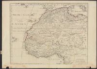
"Avec privil, "The words 'premier geographe du Roi' added in the title ... [indicate] that [a map] could not have been issued before 1718 when [De l'Isle] was appointed to that office"--Tooley, R.V. Guide to maps of Africa, p. 68., and Relief shown pictorially.
Publisher:
chez l'auteur fur le Quai de l'Horloge a l'Aigle d'Or,
Subject (Geographic):
Africa, North--Maps--Early works to 1800 and Africa, West--Maps--Early works to 1800
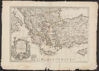
Bar scales given in "milles de Turquie," "lieues marines de France," and "lieues com[m]unes de France"., Covers also Albania, Macedonia and parts of Turkey, Cyprus, Bulgaria, Serbia, Montenegro and Bosnia., O, Prime meridian: Ferro., and Relief shown pictorially.
Publisher:
Chez l'Auteur ...,
Subject (Geographic):
Balkan Peninsula--Maps--Early works to 1800, Cyprus--Maps--Early works to 1800, Greece--Maps--Early works to 1800, and Turkey--Maps--Early works to 1800
Hand col. in outlines only. Sheet measures 58.2 x 79.8 cm., Includes five bar scales., Prime meridian: Ferro., Relief shown pictorially., and Watermark.
Publisher:
Chez l'Auteur ...,
Subject (Geographic):
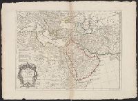
Africa, Northeast--Maps--Early works to 1800 and Middle East--Maps--Early works to 1800
Hand col. Mounted on linen. Sheet measures 65 x 49 cm. Ms. n, Has watermarks., Includes index and ill., Oriented with north to the bottom., Relief shown by hachures. Depths shown by soundings., and Shows fortifications and coastal defenses in the Gibraltar region.
Publisher:
Chez Basset, rue St. Jacques, au coin de delle des Mathurins,
Subject (Geographic):
Gibraltar, Bay of (Spain)--Maps--Early works to 1800
Subject (Name):
Coquart, A
Subject (Topic):
Coast defenses--Spain--Gibraltar, Bay of--Maps--Early works to 1800 and Fortification--Spain--Gibraltar, Bay of--Maps--Early works to 1800
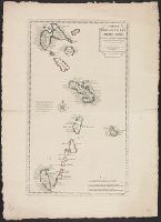
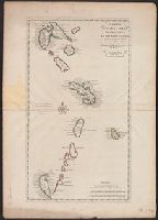
Includes text to left of compass rose: En 1706, le R.P. Feuillée observa dns l'Isle de la Martinique..., Includes three bar scales: lieues communes de France, lieues marines de France et d'Angleterre, and lieues marines d'Espagne., Relief shown pictorially., and Shows islands from Guadeloupe to Grenada, including Barbados.
Publisher:
Chez I'auteur sur le Quay de l'Horloge,
Subject (Geographic):
Antilles, Lesser--Maps--Early works to 1800, West Indies, French--Maps--Early works to 1800, and Windward Islands (West Indies)--Maps--Early works to 1800
Hand col. Sheet measures 75.5 x 54 cm. Ms. no. on verso [some, Includes text to left of compass rose: En 1706, le R.P. Feuillée observa dns l'Isle de la Martinique..., Relief shown pictorially., and Shows islands from Guadeloupe to Grenada, including Barbados.
Publisher:
Chez I'auteur sur le Quay de l'Horloge,
Subject (Geographic):
Antilles, Lesser--Maps--Early works to 1800, West Indies, French--Maps--Early works to 1800, and Windward Islands (West Indies)--Maps--Early works to 1800
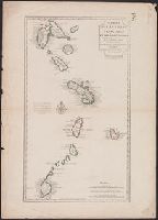
"Cette carte a été rectifiée en 1769 par Phil. Buache.", Cross Collection no. 257., Hand col., Includes three bar scales: lieues communes de France, lieues marines de France e, Ms. no. on verso: 134., and Relief shown pictorially.
Publisher:
Chez Dezauche, successeur des Srs. Del'Isle et Bauche ...,
Subject (Geographic):
Antilles, Lesser--Maps--Early works to 1800, West Indies, French--Maps--Early works to 1800, and Windward Islands (West Indies)--Maps--Early works to 1800
Subject (Name):
Buache, Philippe, 1700-1773, Dezauche, J, and Petit, Jean de
Crépy, Etienne Louis, printer Fricx, Eugène-Henri, d. 1733 Fricx, Eugène-Henri, d. 1733. Cartes des provinces des Pays Bas
Published / Created:
[1743]
Call Number:
1977 Folio 177
Image Count:
2
Resource Type:
Maps, Atlases & Globes
Description:
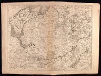
"No. 7" in lower right corner., Bar scales given in "echelle de deux Lieues et demie com[m]une de France" and "echelle de deux Lieues de Brabant"., From Fricx's Cartes des provinces des Pays Bas, 1744., Relief shown by hachures., Sheet measures 54.7 x 73.6 cm. No. 17 of 34 maps bound together., and Watermark.