Search
You Searched For
Search Results
- Creator:
- Bowen, Emanuel, -1767
- Published / Created:
- 2d. July 1772.
- Call Number:
- 71 1763
- Container / Volume:
- BRBL_00364
- Image Count:
- 4
- Resource Type:
- Maps, Atlases & Globes
- Alternative Title:
- Particular map of Baffin and Hudson's
- Description:
- map of Baffin and Hudson's Bay" and "The
- Subject (Geographic):
- North America--Maps--Early works to
- Subject (Topic):
- British--America--Maps--Early works to
- Found in:
- Beinecke Rare Book and Manuscript Library > An accurate map of North America [cartographic material] : Describing and distinguishing the British and Spanish dominions on this great continent; according to the definitive treaty concluded at Paris 10th Feby. 1763. Also all the West India Islands belo
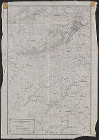
- Creator:
- Merrill, W. E. (William Emery), 1837-1891
- Published / Created:
- 1864]
- Call Number:
- 787hc 1864C
- Container / Volume:
- BRBL_00517A
- Image Count:
- 2
- Resource Type:
- Maps, Atlases & Globes
- Alternative Title:
- [Sherman map collection ; no. 22]
- Subject (Geographic):
- Alabama--Maps
- Found in:
- Beinecke Rare Book and Manuscript Library > Part of northern Georgia : / compiled under the direction of Capt. Wm. E. Merrill, Chief Top'l Eng'r, D.C.
- Creator:
- Scull, Nicholas, 1686?-1761?
- Published / Created:
- 1759
- Call Number:
- 774 1759
- Container / Volume:
- BRBL_00497
- Image Count:
- 3
- Resource Type:
- Maps, Atlases & Globes
- Alternative Title:
- Map of the improved part of the
- Subject (Geographic):
- political divisions--Maps--Early works to 1800
- Found in:
- Beinecke Rare Book and Manuscript Library > To the honourable Thomas Penn and Richard Penn...this map of the improved part of the province of Pennsylvania is humbly dedicated / by Nicholas Scull ; engraved by Ja. Turner.
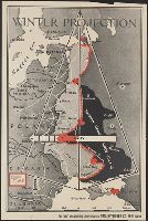
- Creator:
- Chapin, R. M., Jr
- Published / Created:
- 1943
- Call Number:
- 11hd 1939-1
- Image Count:
- 1
- Resource Type:
- Maps, Atlases & Globes
- Description:
- "Enlargement of original map drawn for
- Subject (Geographic):
- Europe, Western--Maps
- Subject (Topic):
- , Western--Maps
- Found in:
- Beinecke Rare Book and Manuscript Library > Winter Projection / TIME map by R. M. Chapin, Jr.
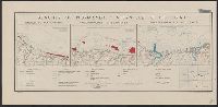
- Creator:
- United States. Office of Strategic Services. Research and Analysis Branch
- Published / Created:
- [1943]
- Call Number:
- 382 1943
- Container / Volume:
- BRBL_00175
- Image Count:
- 1
- Resource Type:
- Maps, Atlases & Globes
- Description:
- "22 November 1943."
- Subject (Geographic):
- Normandy (France)--Maps
- Subject (Topic):
- Beaches--France--Normandy--Maps
- Found in:
- Beinecke Rare Book and Manuscript Library > Beaches of Normandy - Vierville to Houlgate [cartographic material] / compiled and drawn in the Branch of Research and Analysis, OSS.
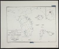
- Creator:
- United States. Office of Strategic Services. Research and Analysis Branch
- Published / Created:
- 1944
- Call Number:
- 28 1944D
- Container / Volume:
- BRBL_00023E
- Image Count:
- 1
- Resource Type:
- Maps, Atlases & Globes
- Description:
- "No. 3417--R & A, OSS; 22 June 1944."
- Subject (Geographic):
- Visayan Islands (Philippines)--Maps
- Subject (Topic):
- --Maps
- Found in:
- Beinecke Rare Book and Manuscript Library > Philippine Islands, transportation facilities of the northern Visayan Islands.
- Creator:
- United States. Office of Strategic Services. Research and Analysis Branch
- Published / Created:
- 1944
- Call Number:
- 28 1944C
- Container / Volume:
- BRBL_00023E
- Image Count:
- 1
- Resource Type:
- Maps, Atlases & Globes
- Description:
- "No. 3764--R & A, OSS; 22 June 1944."
- Subject (Geographic):
- Visayan Islands (Philippines)--Maps
- Subject (Topic):
- --Maps
- Found in:
- Beinecke Rare Book and Manuscript Library > Philippine Islands, transportation facilities of the southern Visayan Islands.
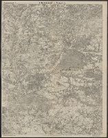
- Published / Created:
- 1918
- Call Number:
- 11hc 1918-Z12
- Container / Volume:
- BRBL_00010G
- Image Count:
- 2
- Resource Type:
- Maps, Atlases & Globes
- Description:
- On verso: Map with "Bl.22.La Malmaison
- Subject (Geographic):
- France--Maps
- Found in:
- Beinecke Rare Book and Manuscript Library > Clermont-Noyon.
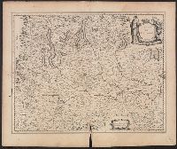
- Call Number:
- 402 M59 1630
- Container / Volume:
- BRBL_00233A
- Image Count:
- 2
- Resource Type:
- Maps, Atlases & Globes
- Description:
- Signature R, page number 22 on verso.
- Subject (Geographic):
- Milan (Italy : Province)--Maps--Early
- Found in:
- Beinecke Rare Book and Manuscript Library > Stato di Milano.
- Creator:
- L'Isle, Guillaume de, 1675-1726
- Published / Created:
- [1730?]
- Call Number:
- 755 1730
- Container / Volume:
- BRBL_00426
- Image Count:
- 1
- Resource Type:
- Maps, Atlases & Globes
- Subject (Geographic):
- Louisiana--Maps--Early works to 1800
- Found in:
- Beinecke Rare Book and Manuscript Library > Carte de la Louisiane et du cours du Mississipi / dressée sur un grand nombre de memoires entr'autres sur ceux de Mr. le Maire, par Guillme. de L'Isle de l'Academie Rle. des Sciences.