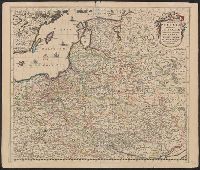
Regni Poloniae et Ducatus Lithvaniae Voliniae, Podoliae Vcraniae Prvssiae, Livoniae et Cvrlandiae descriptio
Description:
Appears in various editio, Bar scale given in "Duytsche Mylen.", Prime meridian: Ferro., Relief shown pictorially., Sheet measures 52.2 x 61.6 cm., Variant giving westernmost longitude at 35 degrees and easternmost longitude at 63 degrees., and Watermark.
Publisher:
[Frederik de Wit,
Subject (Geographic):
Baltic States--Maps--Early works to 1800, Belarus--Maps--Early works to 1800, and Poland--Maps--Early works to 1800
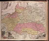
"Cum privilegio ordinum Hollandiae & Westfrisie.", Backed with paper. Sheet measures 53.8 x 62.3 cm. No. 79 of 87 maps bound together., Bar scales given in "milliaria Germanica" and "milliaria Gallica.", and Relief shown pictorially.
Publisher:
[Gerard van Keulen,
Subject (Geographic):
Baltic States--Maps--Early works to 1800., Poland--Maps--Early works to 1800., and Ukraine--Maps--Early works to 1800.
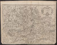
Bar scale given in "miliaria Germanica communia"., From Henricus Hondius and Joannes Janssonius's Atlas (English ed.), 1636., Imperfect: trimmed, with, In English on verso; with caption title "The description of the Bishoprick of S, and Relief shown pictorially.
Publisher:
Sumptibus Henrici Hondij,
Subject (Geographic):
Salzburg (Austria : Land)--Maps--Early works to 1800
Subject (Name):
Hondius, Hendrik, 1597-1651. Atlas novus. English and Jansson, Jan, 1588-1664. Atlas novus. English